
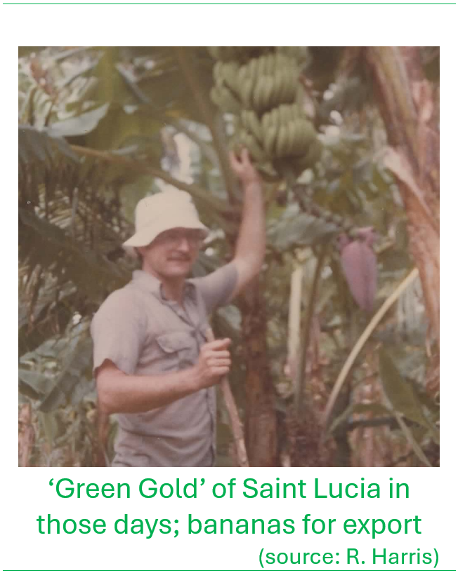
Robert ‘Rob’ Harris was the CIDA/St. Lucia Forest Surveyor 1982-1987 now living in Cobourg, Ontario, Canada.
Preamble:The Forest Boundary Survey was included in the Canadian International Development Agency (CIDA) Saint Lucia Forest Management Assistance Project that was conceptualized in 1981 following the recommendations of virtually all visiting technical experts to the island, dating back to the late 1800s, that called for a full legal survey and gazetting of all forest areas on the island that were important for water, soil and wildlife conservation. The importance of this was emphasized by Gabriel Charles, who at the time was the Chief Forest Officer, the urgent need, echoed by his staff.
I was retained under contract by the project as Forest Surveyor to undertake the daunting task of surveying all the government forest reserves between 1982 and 1987. This was under the Forest Management Project that was financed by the Government of Canada through the Canadian International Development Agency (CIDA). The job was essential because the Reserve boundaries were unknown, the Reserves ungazetted and all of them subject to heavy squatting and encroachment pressure in those days. Vital forest and watershed areas went unmanaged because no one knew their precise location and size, their boundaries or their ownership.
My recount below was extracted mainly from my ‘Forest Surveyor Final Report’ delivered at the end of my stint in Saint Lucia in 1987.
Contributed by Robert Harris, April 2026
Getting the job and arriving in St. Lucia
In the winter of 1982, I saw an advertisement for an Ontario Land Surveyor (OLS) to work in Saint Lucia under a national forestry project. The employer was the Canadian International Development Agency (CIDA) (since disbanded and incorporated under Global Affairs Canada) and the project was known as the St. Lucia-Canada Forestry Management Project. The advertisement specified they wanted a surveyor with forestry training. That was good for me as I was a graduate of University of Toronto in Forestry.
I went to the library to read up about St. Lucia and to see where it was. I submitted an application and was amazed to be called for an interview. The early 1980s were very difficult for surveyors working in Ontario. Job opportunities were few and far between. I was yet to write my final exam to qualify as a surveyor. I was interviewed by CIDA personnel in Ottawa and a few weeks later I was offered the job conditional on passing the exam and getting my license. I had a huge incentive for studying and passing as I really wanted to see St. Lucia and have a steady job! My library research revealed that the country had suffered from the passage of a recent hurricane (Hurricane Allen, August 1980), and that there was some political instability that was accompanied by looting and vandalism that left shops and businesses within the capital city of Castries boarded up for some time, inheriting the name “Plywood City”.
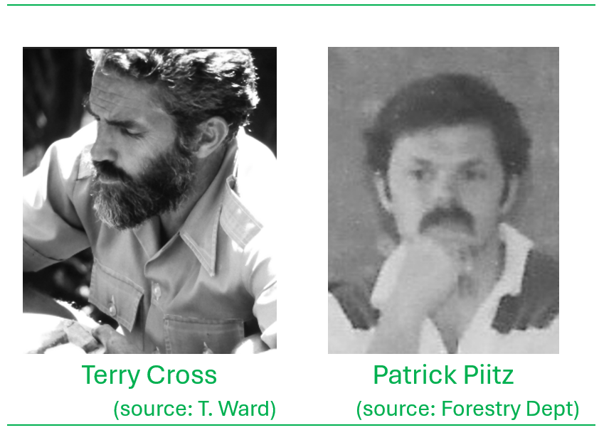
I wrote the OLS exam on April 27th and by late May, I received the news that I had passed the exam. By June 10th I was en-route to St Lucia via Barbados, hired as forest-surveyor and arrived on-island on Sunday, 18th of June, 1982 to start my 9-month contract. I stayed at the Red Lion Hotel just across from the Vigie Airfield (now officially called the George F. L. Charles Airport). Shortly following arrival, I met the key CIDA project members; Terry Cross the project manager and Patrick Piitz the project forester.

The key services I was to deliver under the contract were to survey the existing forest reserves, either by re-establishing existing boundaries or establishing new boundaries, survey proposed forest reserve areas, extending to identification and marking of critical watersheds, supervise the permanent marking of boundaries following the surveys, train the survey crew personnel to support the work, report on progress and achievements, identify problems and provide appropriate recommendations. The work was to be conducted in close advisory support of the CIDA Project team, the Chief Forest Officer and the Commissioner of Crown Lands.
The week following my arrival, I met Forestry Department staff including Gabriel Charles the Chief Forest Officer, and the Lands and Survey staff including Horace Wason who was the Chief Surveyor. These officials reinforced the important need for the project and the work done so far, and how much more work was still required. Gabriel Charles had impressed on everyone, the need for strong watershed protection to safeguard the island’s water supply, and for surveying and mapping all Crown Lands in the island’s interior for protection.
The scope of work
Historically, title to Crown Land in St. Lucia was not clear. French rule had ended with the Napoleonic Wars (Caribbean campaign) but theoretically large portions of land were still in the name of French aristocrats who had left the island in the prior centuries or had never taken up residence. In the final treaty of 1814, the British had promised to respect all existing land rights. The process of getting this land into clear Crown ownership involved surveying and gazetting it. Only when this was done could the Forestry Division and the Lands and Surveys Department administer the forest reserves for conservation.
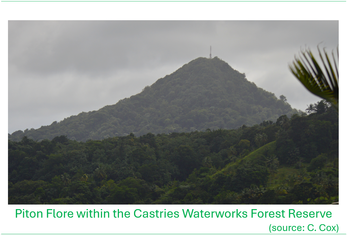
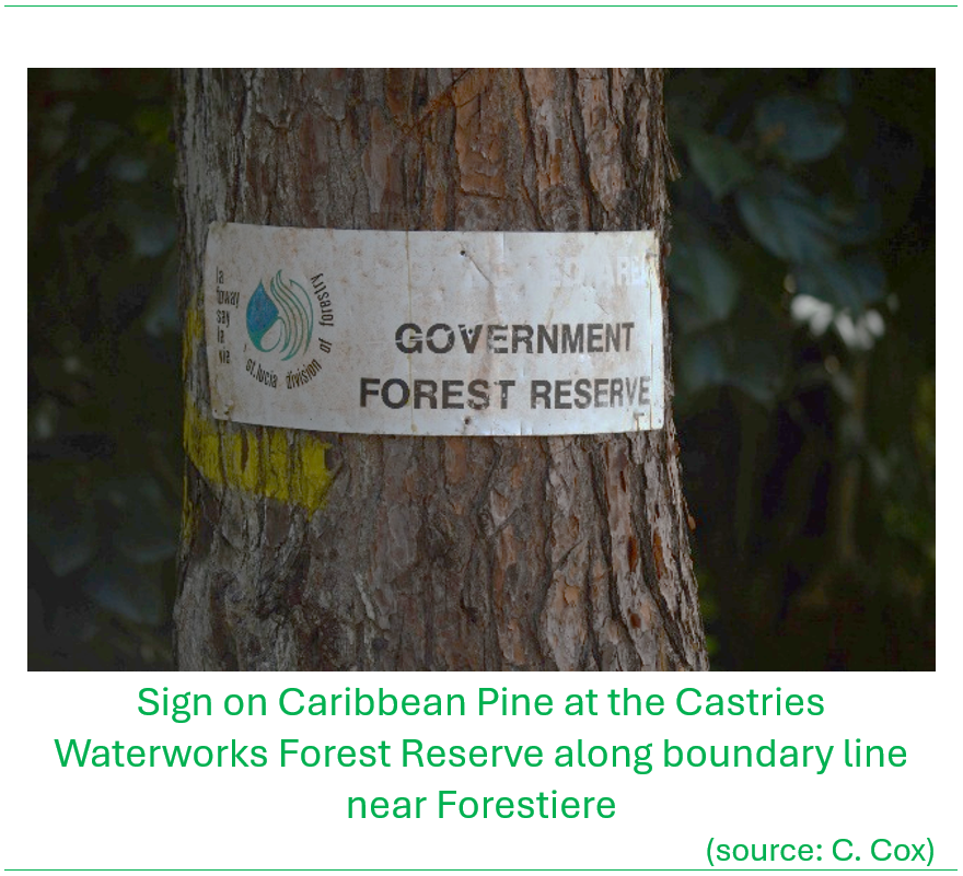
In the first week of my arrival, Tully Mathews from the Lands and Surveys Department took me out to the community of Forestiere and the adjacent forest reserve, encompassing Piton Flore within the Castries Waterworks Reserve. The steep slopes, narrow roads and thick tropical vegetation all impressed on me the difficulty that lay ahead in surveying the Forest Reserve. At one point I got out of the vehicle and almost stepped off a precipice!
We started fieldwork in the summer of 1982. The first task was ‘title searching’ – looking up the survey plans and all legal documents and records for the lands in each work area. The Forest Officers undertook the preparatory site work in locating the starting locations for the surveys, readying the cutlass-men and supporting all the logistics. We started the first surveys at the Barre de l’Isle within the Castries Waterworks Forest Reserve.
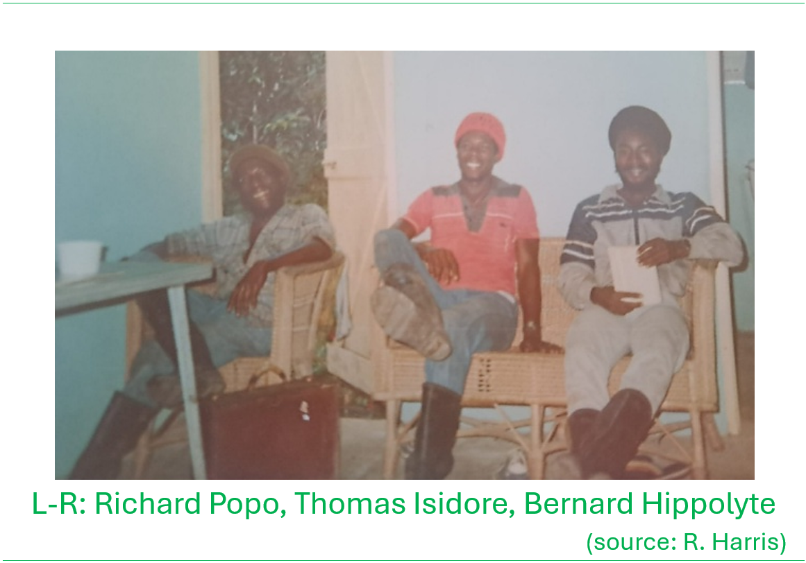
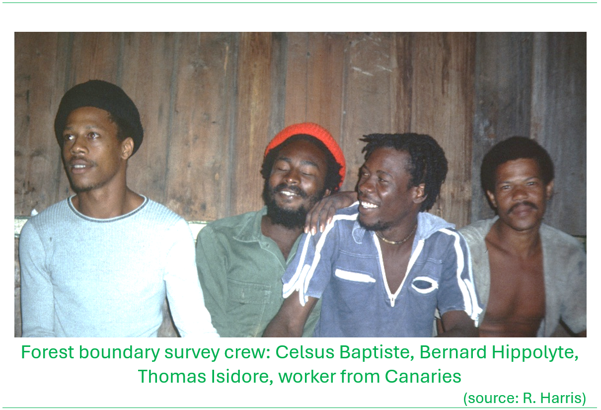
The Lands and Surveys Department assigned two survey technicians to work with me; Richard Popo and Marcus Alcindor. Richard had a lot of very useful experience in the field, however had not attained the equivalent technical education required for the role. Marcus Alcindor was well educated but only an apprentice experience-wise. A third assistant was assigned from Lands and Surveys, Celsus Baptiste, who had similar background as Marcus. The Forestry Division assigned forestry officers to the field work as required, and assisted to recruit cutlass-men from the local communities in proximity to where the survey work was being carried out at the particular time.
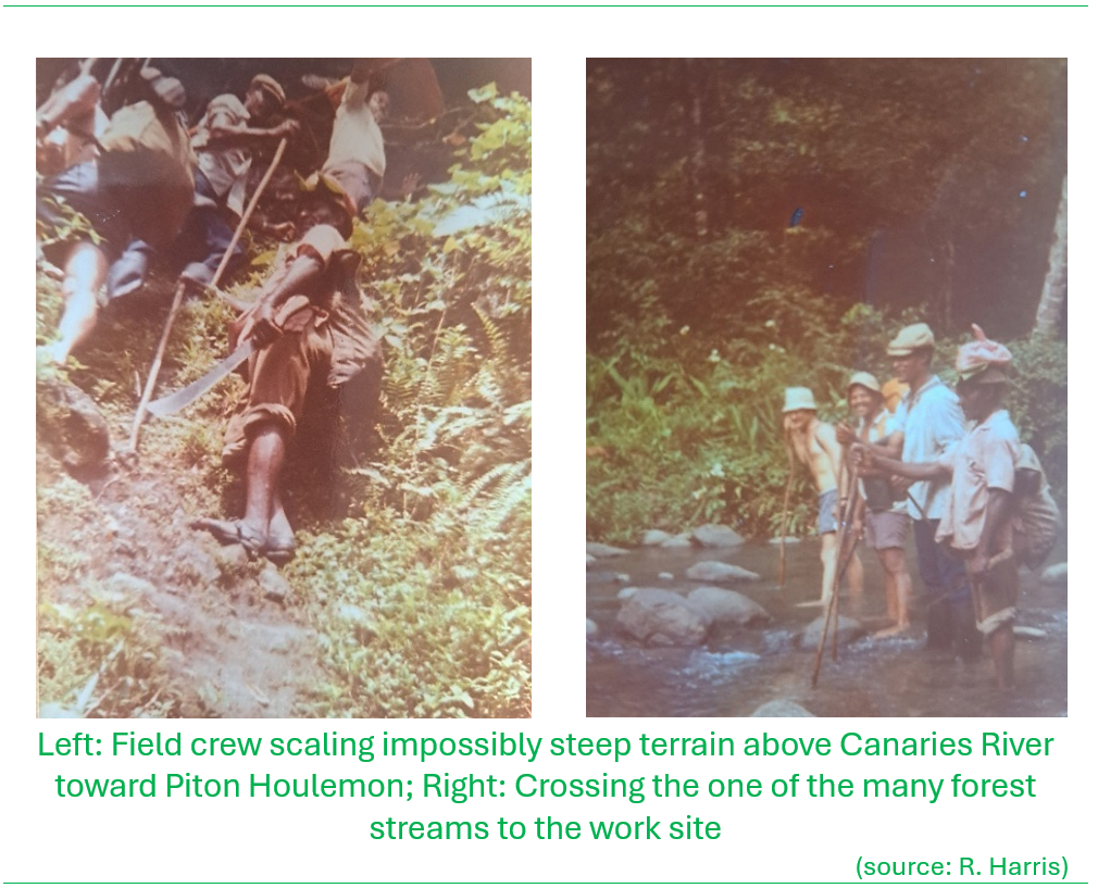
Once I started the work it became immediately obvious to all concerned that nine months would not be sufficient time to complete the forest reserve surveys. There were several reasons; many of the records and survey plans essential to conducting the survey were misplaced or defaced, and a lot of time was required to find them or locate reasonable substitutes. The terrain and dense vegetation cover were extremely difficult to allow for precise survey. In many cases, the actual physical location of the boundary in the field had been completely lost or had become utterly confused, as lost to memory of the adjacent landowners. Many boundary lines between private and government had been established with no regard to topography or contour – especially difficult were those boundary lines that intersected cliffs and escarpments which were highly treacherous to traverse in the field. In addition, the field crews lacked both technical training and practical experience, however this was compensated to some extent by their excellent work attitudes. These very same factors underscored the need for proper surveys and rationalizing the land tenure between the forest reserve areas, adjacent Crown Lands and private lands.
Needless to say, my contract was extended five times until March 1987 to allow for completion of the work.
The routine
During most of the assignment from 1982 to 1987, the team comprised of two apprentice surveyors, Marcus Alcindor and Celsus Baptiste, who led the two main field crews, performed title searches and assisted in calculations and drafting. Richard Popo often led the field crews and assisted in training Marcus and Celsus in field techniques.
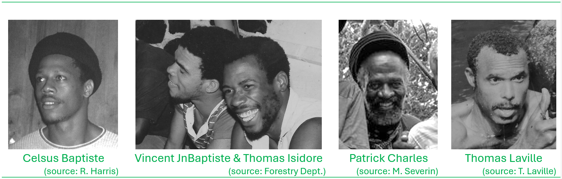
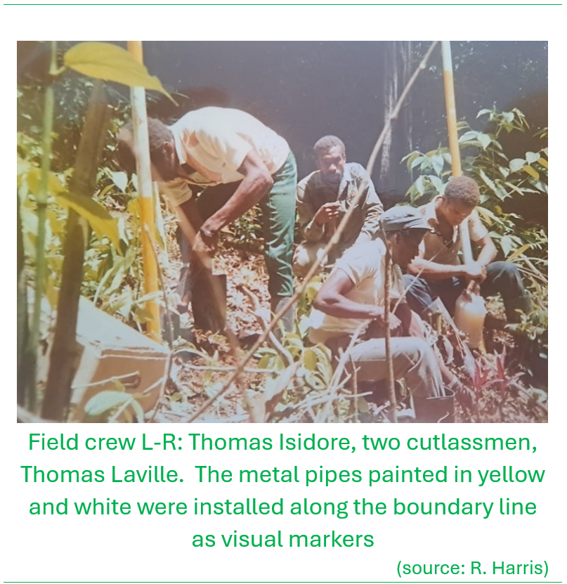
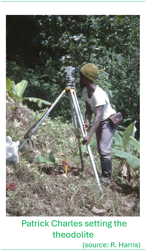
Four survey technicians who assisted on the forest survey, were Patrick Charles, Thomas Anthony Laville and Vincent Jn. Baptiste. The technicians helped the surveyors on the main survey. They also supervised monumentation crews (to install survey markers) and check crews. Thomas Isidore was along for most of the surveys to assist the survey technicians and as a driver.
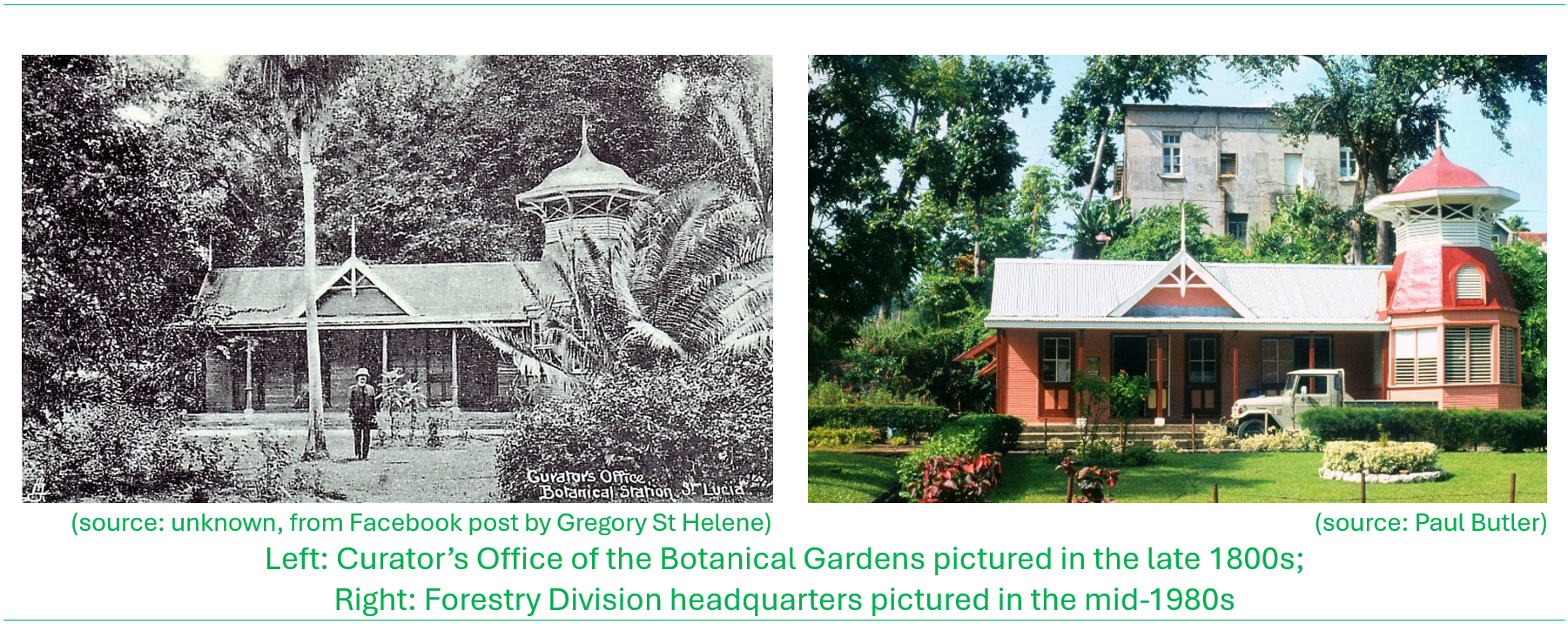
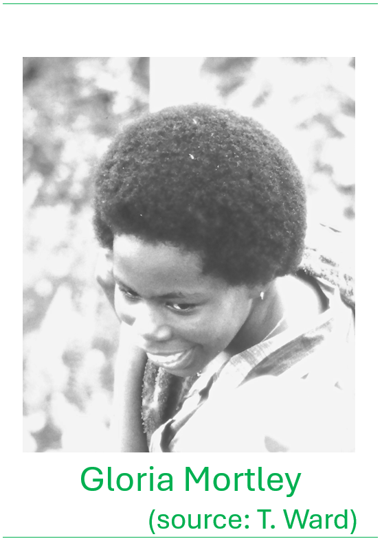
At that time, the Forestry Department was based in George V Park in Castries. I coordinated the field crews and the forest survey from there with office support from the Forestry Department. Gloria Mortley was a Forest Officer who volunteered to be trained as our draftsman-tracer. She worked very hard inking plans and assisting with the simpler calculations.
Prior to survey work for each location, a full land titles search was done at the Department of Lands and Surveys, the Registry Office and the Forestry Division Office, to locate all possible records relating to the forest reserves and adjacent lands. The survey apprentices and staff of the Lands and Survey Department would aid in this where possible. The Forestry staff would assist in locating accommodation or camp sites, and marking sections of the boundary that were known, and in hiring the manual labour. The Forestry and Lands and Surveys staff would locate landowners and give notice of the survey.
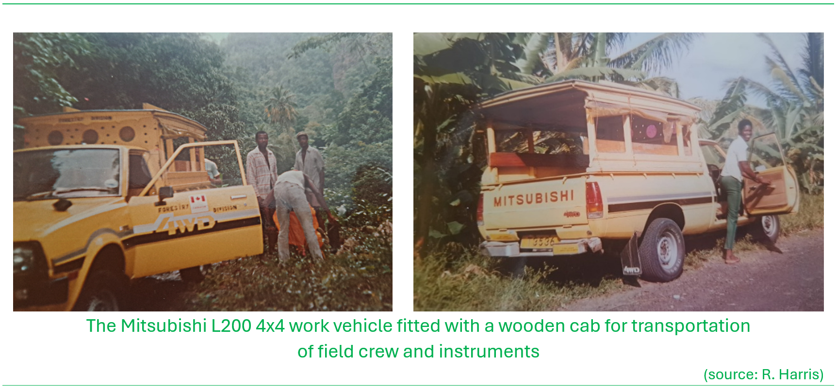
Field work was performed by two crews of six men each, consisting of one apprentice, two technicians and three labourers/cutlass-men each. The labourers/cutlass-men cleared and marked lines, and assisted with moving supplies and survey equipment. These men were hired locally and were often borrowed from nearby Forestry Department operations. Sometimes, one or two of the apprentices or technicians would be detached from the main crews to supervise monumentation and planting crews following behind the main crews. These same methods and manpower, with some modifications, were used to do additional support work for the Forestry Department; carrying out forest tree plantation surveys, watershed surveys and surveys for new land acquisitions. Monuments, white and yellow painted 4-foot galvanized pipes, were cemented in the ground at corner-points along newly surveyed boundary lines, with check work done after the main survey had passed through the area.
Field work was generally done with theodolite and steel tape; connections to the grid were made by intersection, resection, or short-range electronic distance measurement equipment on loan from the Lands and Surveys Department.
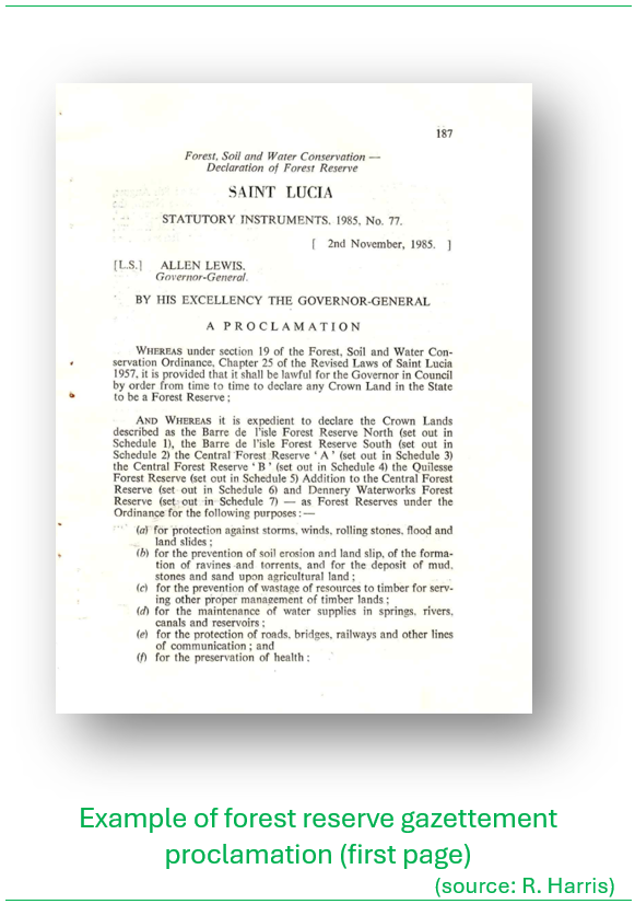
The final survey plans – maps and associated drawings, were prepared by me with help from the apprentice surveyors and the draftsman-tracer Gloria Mortley. The plans were done on mylar film (a type of polyester drafting film) with Leroy lettering. Two transparent duplicates were made of each plan by Diazo process; one for the Lands and Surveys Department and one for Forestry Department records. All plans and drawings were done to as high a standard as possible within the requirements of the Lands and Surveys Department and the Commissioner of Crown Lands. The surveys were done in metric units and all were coordinated surveys on the British West Indies Grid. Gazetting descriptions were drawn up and submitted to the Attorney General’s Office for all Forest Reserves and Protected Forest Areas.
Achievements
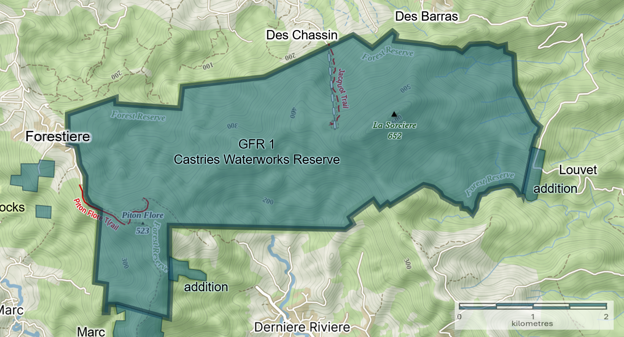
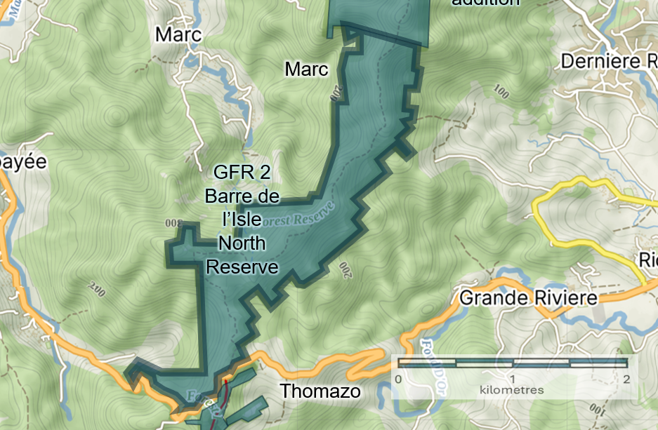
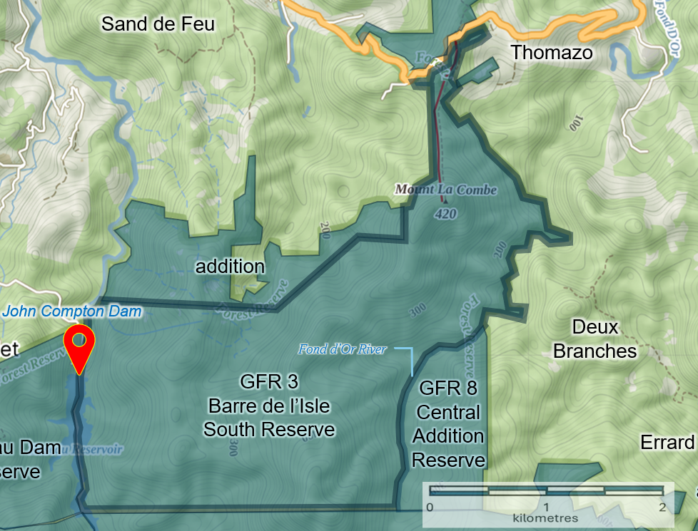
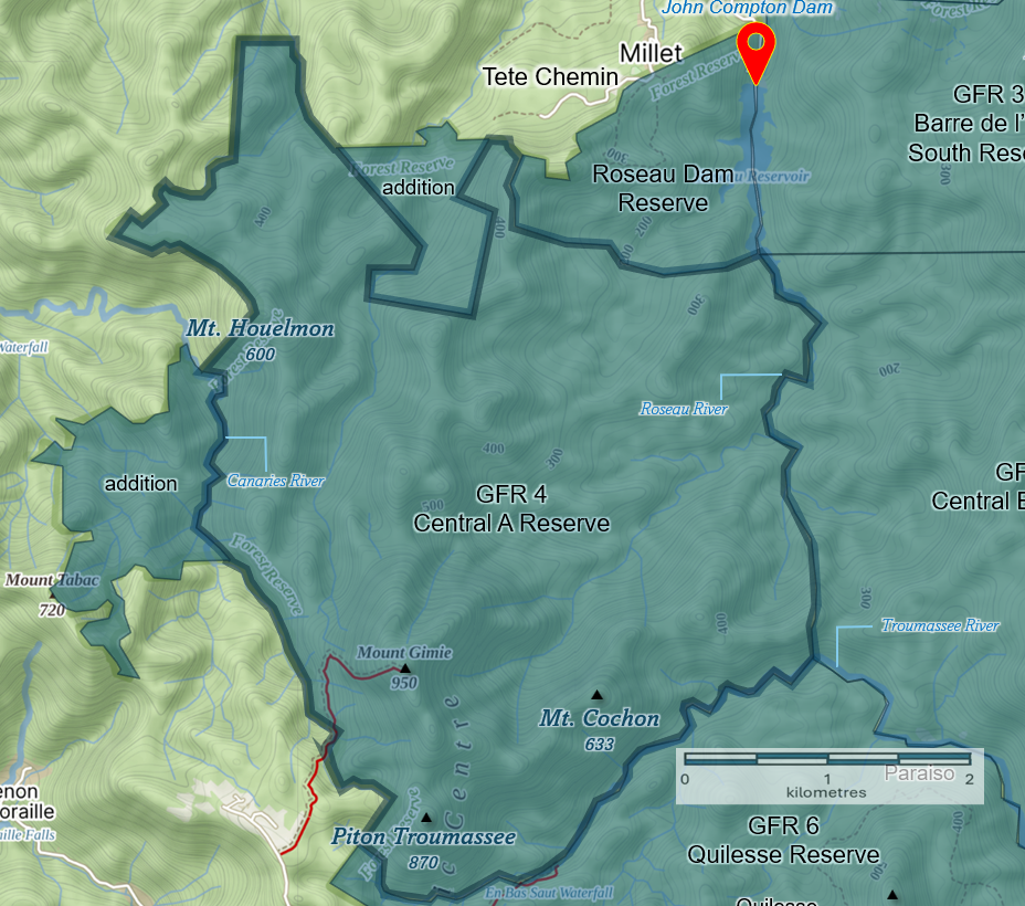
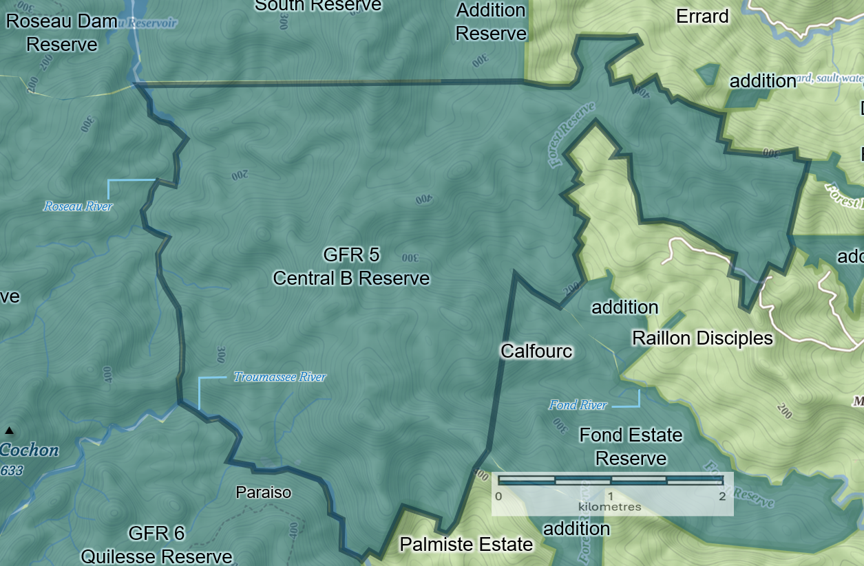
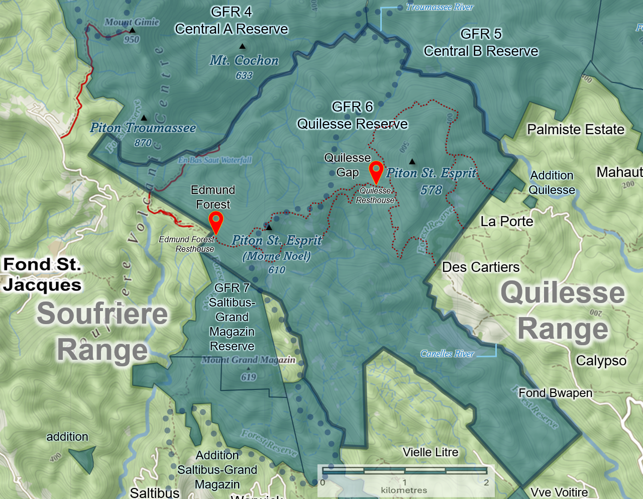
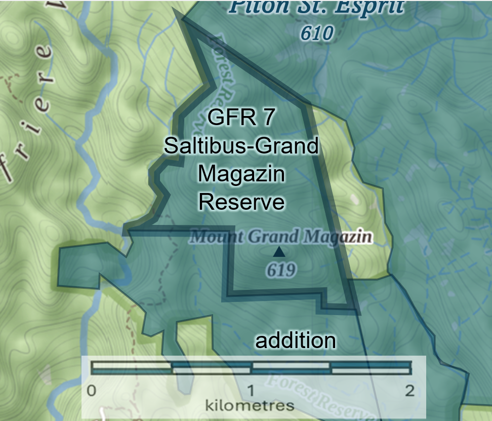
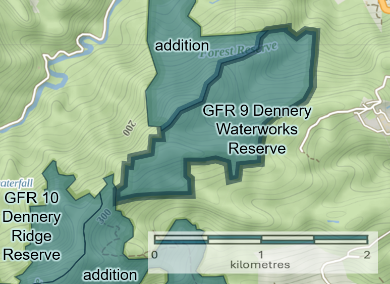
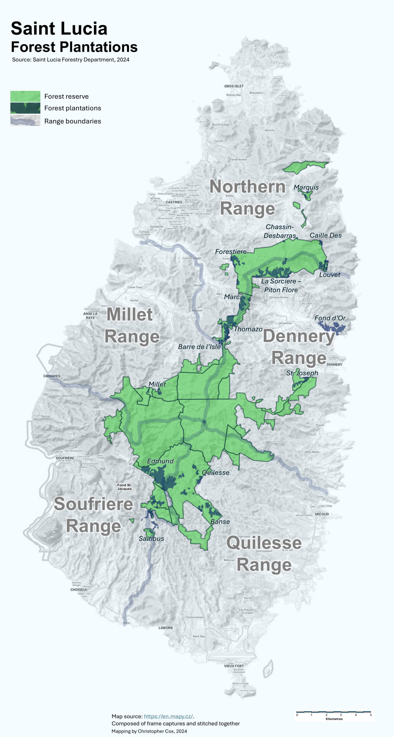
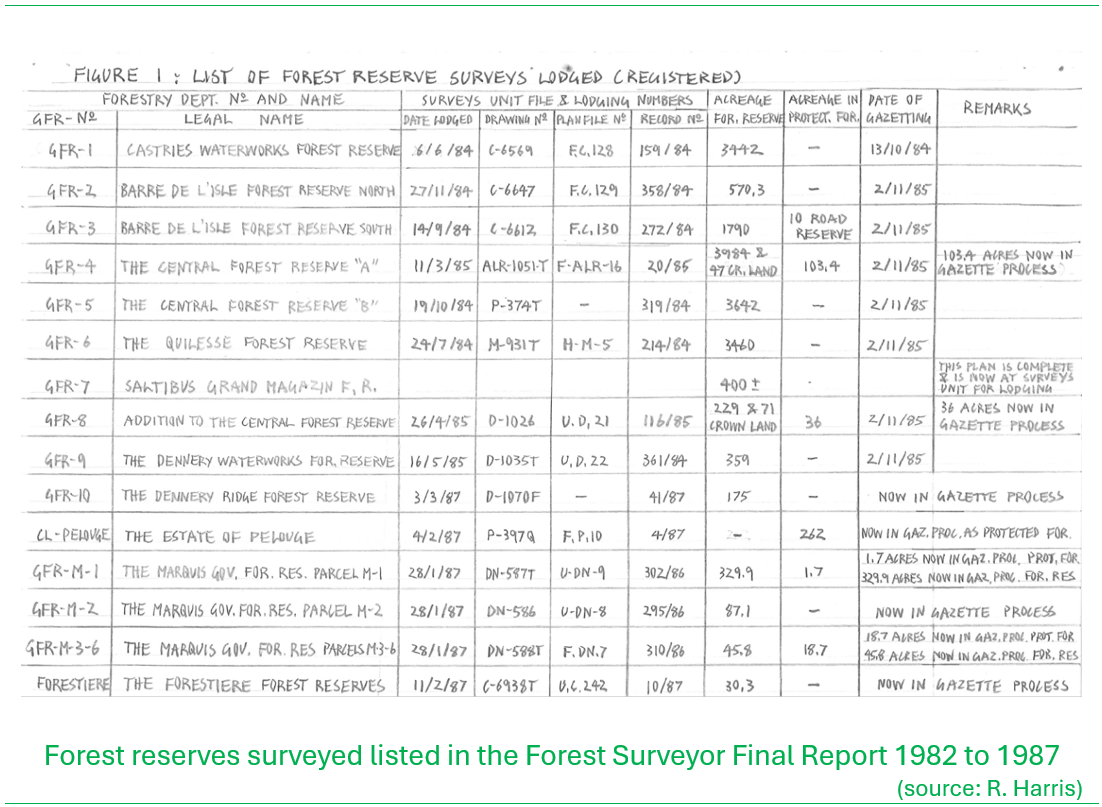
Between June 1982 and June 1985, we completed surveys of all the existing Forest Reserves including additional adjacent Crown Lands that were included as new additions. This constituted 6,857 hectares or 16,945 acres in total. These reserves were Castries Waterworks Reserve, designated GFR 1, Barre-de-l’Isle North Reserve, GFR-2, Barre-de-l’Isle South Reserve, GFR-3, Central Forest A Reserve GFR-4, Central Forest B Reserve GFR-5 and Quilesse Reserve GFR-6. Over the remainder of 1985 we surveyed three new forest reserves in critical watershed areas; Saltibus Grand Magazin Reserve GFR-7, Central Addition Reserve GFR-8, and Dennery Waterworks Reserve GFR-9, totaling some 429 hectares or 1,060 acres.
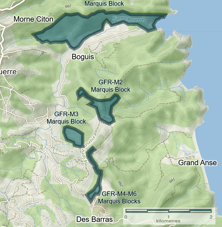
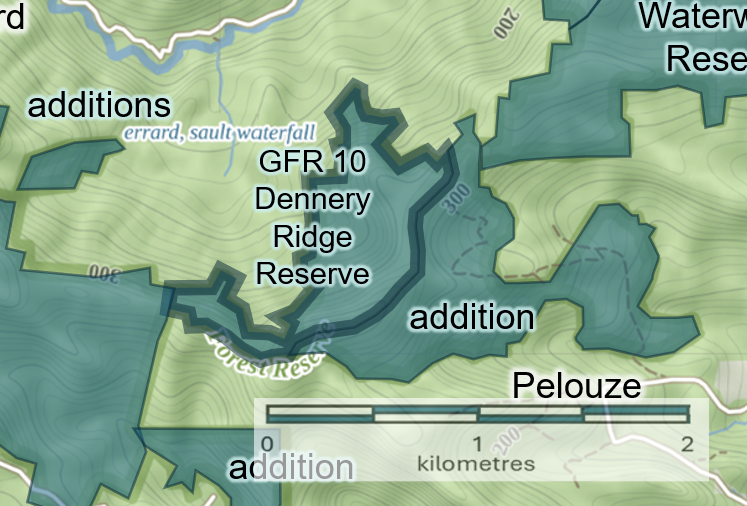
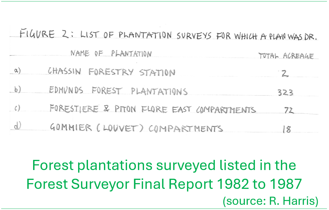
Over 1986 we focused on three other critical works; (1) the survey and mapping of forest plantations, established over past decades for timber supply predominantly; (2) the survey of private lands for acquisition as Forest Reserve by the government for conservation. This included six parcels of land totaling some 187 hectares or 463 acres that were originally part of the Marquis Estate. These were assigned as GFR-M-1 to GFR M-6, the ‘M’ signifying ‘Marquis’; and (3) the survey and mapping of two more critical watershed areas for protection, namely Dennery Ridge Reserve, designated GFR-10 and CL-Pelouge proposed for managed agroforestry development as a protected forest area.
In 1986, Celsus Baptiste, Marcus Alcindor and I taught a one-week course in basic surveying to numerous Forestry Officers. It was funded by the Canadian Training Awards Program and two groups were trained over one week each.

From 1986 and into the final extension of my contract at the end of March 1987 saw the continuation of some of the forest plantation survey work. However, a bigger effort in these final days was in the training of Crown Lands Unit staff, who fell under the Forestry Department, in basic surveying and to support the demarcation and claiming Crown Lands under the Land Registration and Titling Programme that commenced in 1983 and ran until 1987. Much time was also spent advising the Forestry Department on resolving Crown Land disputes.
Work on surveys of new forest reserves and watershed areas continued, with particular emphasis on protection of critical watersheds. André Plamendon who was a professor of Forestry and Geomatics at Laval University and contracted by CIDA, visited the country twice in 1986, and prepared a detailed report to advise the Forestry Department in this area. The government approved the purchase of approximately 32 hectares (80 acres) of land for forest and watershed protection in 1986.
By the close of the assignment in 1987 we successfully surveyed and gazetted (or initiated the process of gazettement) of 7,555 hectares or 18,670 acres of Forest Reserve. Additionally, some 226 hectares (560 acres) of land was gazetted or in the process of being gazetted as Protected Forest Areas.
Conclusions and recommendations
On conclusion of the work in 1987, I submitted my summary report with key recommendations for onward work. These were as follows:
– There needs to be a widening of scope in the Phase II of the CIDA-St. Lucia Forestry Management Project to include an emphasis on watershed management. This should include the incorporation of a Forest Surveyor, an Environmental Planner, and a Watershed Specialist on short-term assignments to the Forestry Department. Training of a St. Lucian in Canada as a Land Surveyor was being sought and should be considered.
– The Government of Saint Lucia must continue its efforts to fill the post of Forest Surveyor. The job description as laid out in the Forest Management Plan developed under the project indicates that there is more than enough work for such a person to be fully employed.
– Now that the Forestry Department includes the Crown Lands Unit with the additional responsibility for continued rationalization of Crown Lands and management for forest conservation and other uses, it is recommended that another dedicated staff surveyor be brought on to focus just on Crown Lands surveys and dispute resolution.
– The survey and demarcation of critical watersheds is to be continued as quickly as possible where the Forestry Department is to provide management plans for each watershed as soon as it is gazetted.
– The posts of ‘Forest Surveyor’ and ‘Crown Lands Surveyor’ described above must be upgraded to the ‘professional level’ staff position suggested in the CIDA Management Plan as necessary to attract sufficiently skilled and dedicated persons.
– The Forestry Department must endeavor, in accordance with the Management Plan, to clear and maintain all boundaries of Forest Reserves and Protected Forest areas.
Below are my summary notes on the forest reserve surveys lodged with the Lands and Surveys Department and the forest plantations that were surveyed.
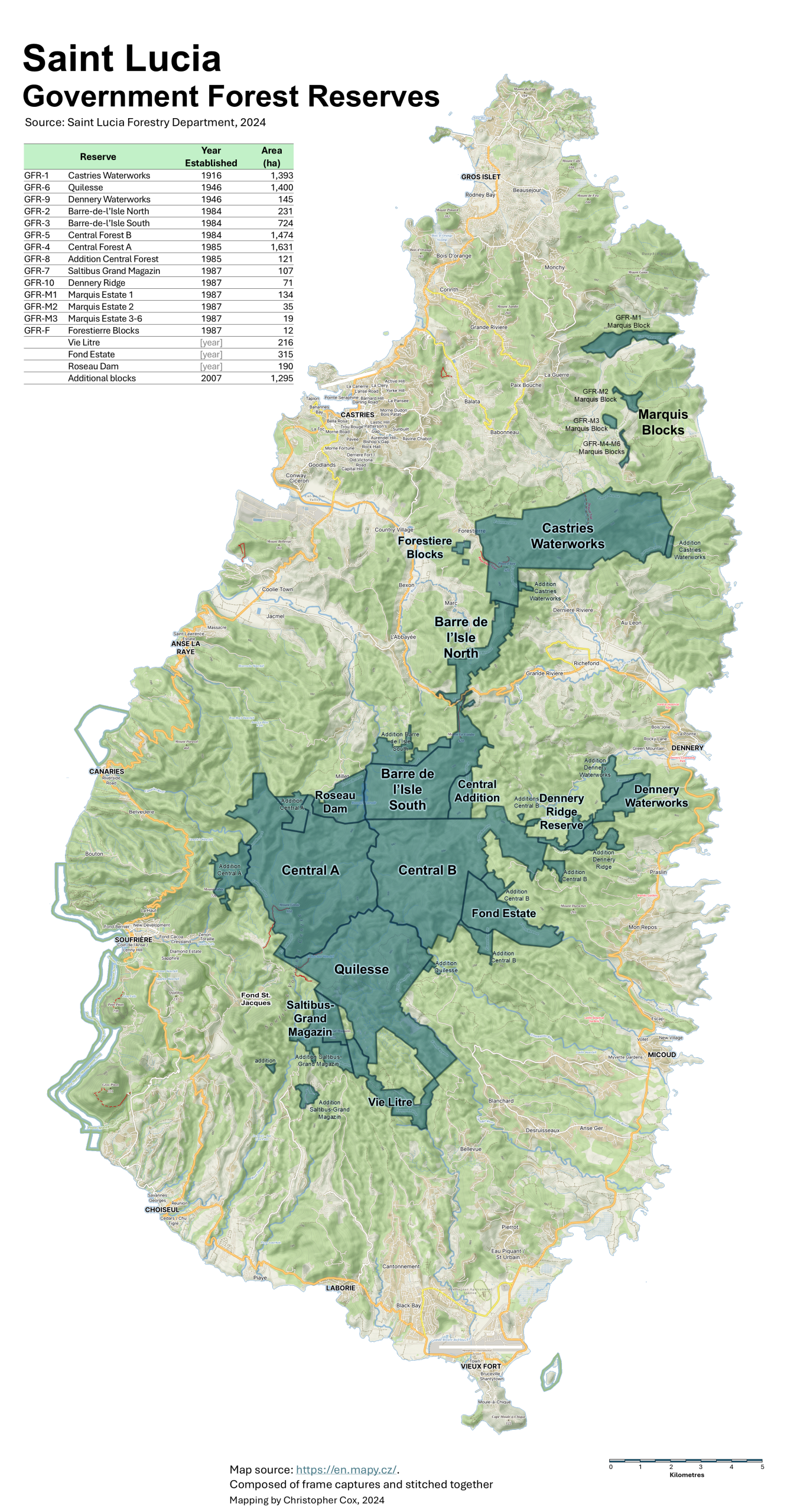
The map shows the the current forest reserves of Saint Lucia. This includes areas that were surveyed and gazetted since my work there.
Tap or click on the map below to view a high-resolution version
A journey…in more ways than one
During my time in Saint Lucia, I often worked with or socialized with Peace Corps Volunteers from the United States who were assigned to various social development initiatives on the island. It was sometime late in 1983 when Paul Butler (from the UK, who was the Conservation Advisor to the Forestry Department at the time) and I, learned that two new female Peace Corps were soon to arrive on island. Of course, as young eligible ex-pat bachelors (laugh) we headed off on the day of their arrival to the Vigie Airport to see the plane as it arrived from Barbados. Through the fence we saw two young women who could only be the Peace Corps Volunteers, disembark the aircraft…and they were attractive!

Sometime later I was told that one of them, Penny Watt, was a teacher at the Saint Lucia School for the Deaf. She was an experienced teacher who had worked in Illinois and Iowa. Penny was a very hard-working volunteer. In addition to the School for the Deaf, she taught sign language classes at night and she organized many fund-raising activities for the school. Often, she and the girl students would bake cakes and take their cake wagon to downtown Castries on Saturdays to sell cake. Penny did call-in radio shows to educate St. Lucians on deaf education and to raise funds for the school.
Until I met Penny, a lot of my time was spent working. Penny was outgoing and well liked and she had lots of American friends through the Peace Corps and lots of St. Lucian friends through teaching. Our paths gradually crossed more and more. She got me out of my shy shell to frequent the Gros Islet Friday night street party, go to parties and ‘jump j’ouvert‘. By 1984 we were dating, and by 1986 we were planning on marriage.
In 1987 both our contracts ended and we got married in Illinois in May 1987. We are still together today and have two adult children in Canada who get to hear our St. Lucian memories over and over!
On reflection
When I arrived in Saint Lucia in 1982, I had never been outside of Canada. From day one I was enthralled by the mountains, thick vegetation and tall forests. The people were very welcoming; the roads so narrow but with fast drivers; the food very exotic and good. I felt I was home from day one.
The Forestry Department staff showed me around and they were very enthusiastic. However I could see that with the steep rugged terrain, heavy forest cover and a staff who was fairly new to surveying, that we would have a lot of work ahead. Despite the tough and grueling conditions under which we worked for long days, in some of the most remote isolated regions of the island, it was a deeply rewarding experience to have made an indelible contribution to the improved management of forests in Saint Lucia. The five years I spent on the Forest Survey were the most exciting and challenging of my life. Not a day goes by when I don’t think of St. Lucia and all the wonderful friends and co-workers I met there.
I was grateful to Gabriel Charles and all the staff of the Forestry and Lands Department, Horace Wason, the Chief Surveyor and staff of the Lands and Surveys Department, and all the other people both in government service and outside it, who did so much to help and advise me during my time in St. Lucia. My contract came to a close on 31st March 1987 and I left the island in April, 1987.

Would love to hear from you! Leave your comments below!
Harris- thank you for contributing that very informative recounting of your time and work in St Lucia. I always enjoyed hanging out with you Penny and your generosity in other Peace Corps Volunteers rides when needed!
I forwarded this to Mark Miller also.
Hey Scott
Great to hear from you. Let me know if you receive this reply.
We are both well.
Cheers
Rob and Penny
Mr. Harris, your work helped lay the foundation for the protection and management of many of Saint Lucia’s critical forest reserves and watersheds. I have also worked with the Department of Forestry in Saint Lucia for over 20 years as an Environmental Education Officer, and I would like to thank you for your tremendous contribution to the island’s forestry and conservation sector.
I have two questions for you:
1. Were there any areas of the island that particularly stood out to you for their beauty or ecological importance?
2. Were there any moments during field work that were especially dangerous or unforgettable?
1) The areas that were most impressive to me were the Canaries/Soufriere mountain ridges. The Terrain and vegetation were so Different to the rest of the Island (except for possibly Grand Magazin in Saltibus.
Edmund Forest: There were some river gorges that were a serious challenge. Sometimes they were the most usable way to traverse to and from the Camp.
Celsus, thanks for your contribution here! You guys set foot on tracts of the island few have ventured. I must thank you (Rob and Vincent too) for your teaching and mentoring my surveying skills when I was assigned to the Crown Lands section under Forestry to do the Crown Lands demarcation work with the LRTP…40 years ago!
Hello Feria Narcisse
All the reserves were scenic! My favorites were the areas with steep terrain and heavy rainfall.
The areas above Canaries had very challenging ground. Once I walked from our camp above Canaries to the road below Millet. This was a walk I can’t forget as it was totally exhausting.
The Calfourc River on the east side of St. Lucia had a lot of snakes!
Wow! What an amazing document you’ve created, Rob!
I never really understood all the challenges (and rewards) you experienced in the incredibly tough work you did in St Lucia, particularly impressive given your young age and relative inexperience when you started the job.
The way you built the team and strategized the project, making many friends along the way, really speaks to your skill and maturity, not to mention the excellence of the folks you worked with.
What an adventure you had!
I’m really proud of you and will treasure this well-written and illustrated narrative. You know what: this could be a post-graduate thesis! Maybe you’ll pursue that when you complete your current college program!
Nancy
Congratulations from your very proud sister Nancy!