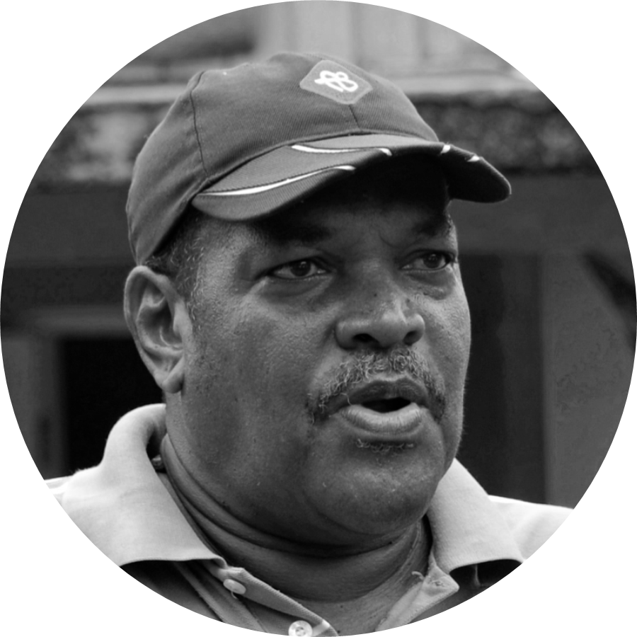
Ananias Verneuil Forest Guard 1970-1974, Forest Officer 1974-1985, Range Officer 1985-2009. Saint Lucia Forestry Department
Compiled from an interview with Christopher Cox, August 2024
Early motivation to work in forestry
I think I was always drawn to working in the environment. As a school student, I had taken up interest in science, being fascinated with the plants and the forest, recalling learning about things like transpiration and how this worked at the level of the forest. As teenage boys we used to explore places in the heights beyond Fond St Jacques where I remember there was a trail we used to frequent that went from Zenon all the way to Mt. Gimie. We used to climb the Sulphur Springs Mountain on adventuring and would climb Morne Tabac. It was during these days I began to learn more and understanding the way in which the forest provided shelter for wildlife and water, and how it protected the environment in general. I could see how the conditions and characteristics of the forest varied depending on where you were, that was dependent on things like the slope of the land, the depth of the soil and the amount of rainfall the area received. It made me appreciate that there were complex interactions going on and how species of plants became uniquely adapted to these conditions. I found it interesting as I advanced in my career, I could realize how the older generations who relied on the forest for livelihood, understood all of this very well; the importance of the forests for life…they however expressed it in their own way; not with the scientific terms that we may use or be accustomed to.
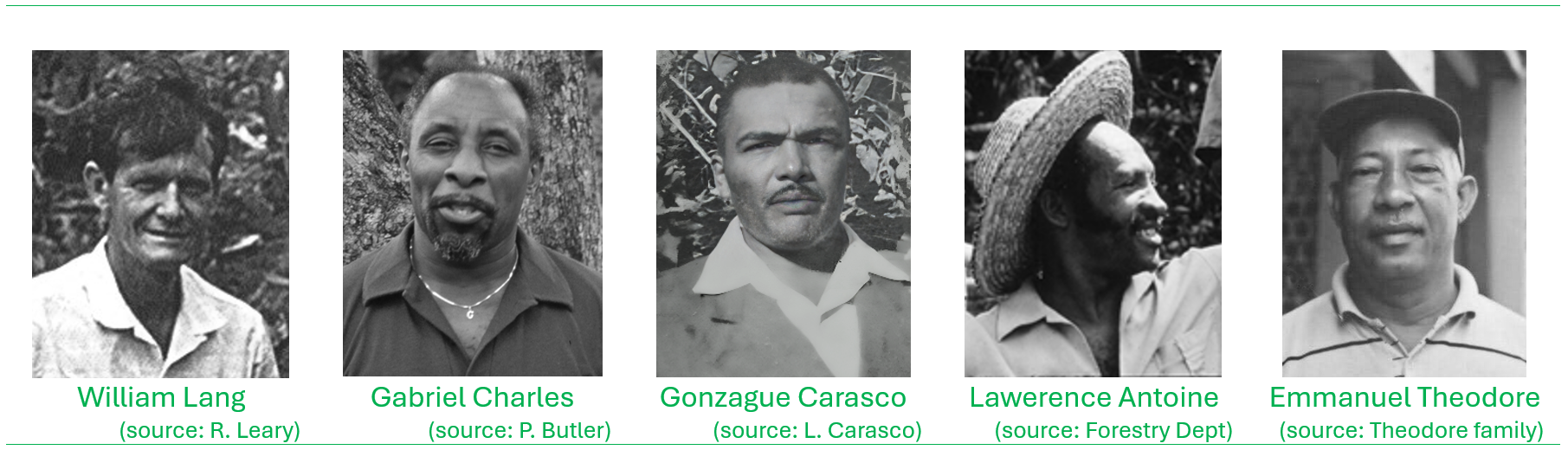
I joined the Forestry Division straight out of school just shy of 17 years in August 1970 as a forest officer assigned to the Quilesse Forest Range. At the time William Lang was the Forestry Supervisor. I worked with Emmaneul Theodore in Quilesse Range during the period when the range was under management of Gonzague Carasco. Gabriel Charles (aka ‘Charlo’, ‘Coco Charles’) was in charge of Edmund Forest, and after he was assigned to the Forestry Division head office, Lawrence Antoine took over supervision of Edmund Forest. On Gonzague Carasco’s retirement, Felix James took over management of Quilesse Range. Later Emmaneul Theodore was transferred to oversee operations at Edmund Forest after Lawrence Antoine was promoted and assigned to the Forestry Division head office. I overlapped with William Lang who was the Forestry Supervisor for about two years before his retirement. Following his retirement David Moore from England was appointed as interim Forestry Supervisor up to 1974/75. In those days there was one senior officer attached to each of the forest ranges where their work was assisted by a team of Forest Guards.
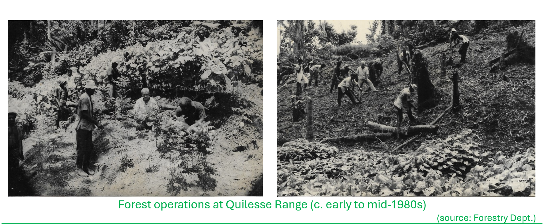
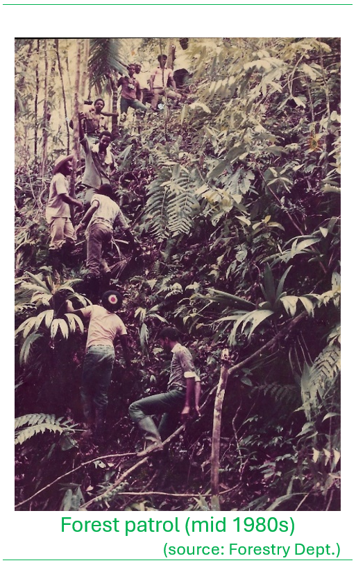
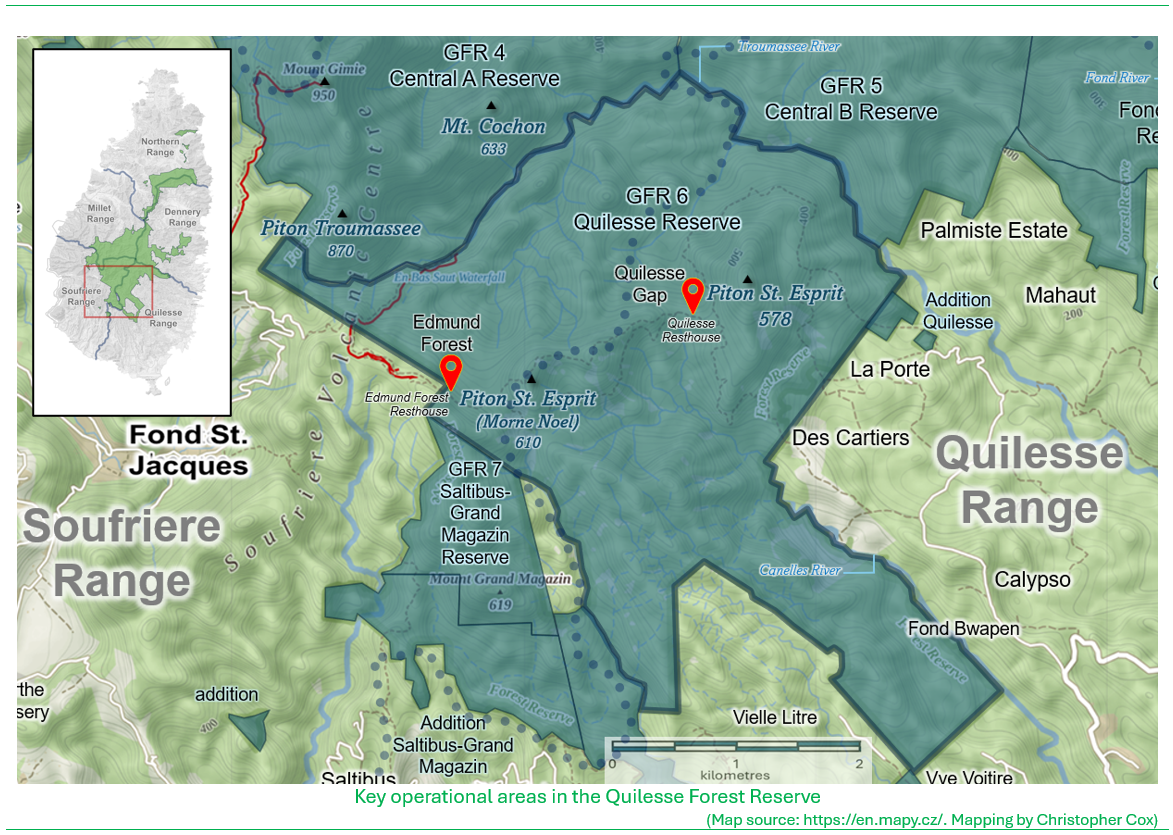
The Quilesse house; the base of forest operations
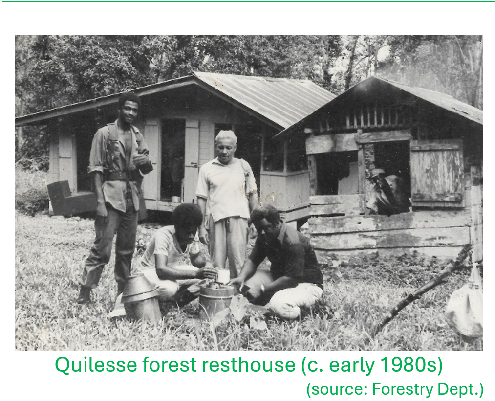
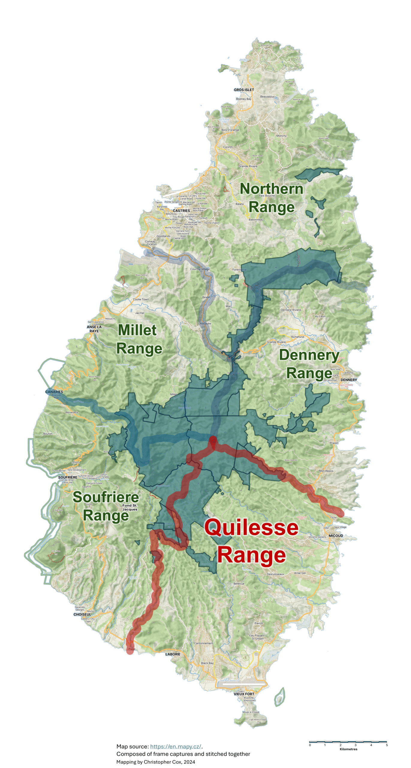
Quilesse is an extensive forested area that lies upland from Mahaut in the southeastern mountains of the island. In this area well into the forest, the Ministry of Agriculture established an agricultural station a long time ago (refer to the location map for places mentioned in the narrative at the end of the post). The area was planted with grapefruit and orange groves, in addition to forest trees such and Honduras Mahogany (Swietenia macrophylla) (uphill in a small plantation at Paraiso. Produce from the agricultural station used to be carried on the head via a trail to the Mahaut area at the Mahaut bridge where the road ended at that time. Over time the agricultural station was abandoned and the fruit groves became shaded out by the forest canopy with the oranges dying out; the grapefruit groves survived on. I recall that there was a house that remained from the agricultural station days, however Gonzague Carasco built in the same location, what was the first forest resthouse at Quilesse, likely in the late 1950s or early 1960s. This would be the base for the conduct of forest operations, which in those days entailed monitoring the forest for squatting infractions, timber production and monitoring wildlife. I remember that there was an old Brigand track that was carved into the slope following the contour, similar to the Des Carters trail that is now being used as the main ecotourism trail that takes one from Quilesse to Edmund Forest, and eventually into Soufriere (Brigands were runaway slaves that fought the French and British colonialists from strongholds in the forested interior of the island). Also in the vicinity there was a trail that took you to the top at the microwave reflector on Piton St. Esprit and at Quilesse Gap there was a track that led to the Quilesse River (headwater tributary of the Troumassee River). All these trails that criss-crossed the forest in the Quilesse area and the interior mountains were no doubt first established by the Brigands.
Commercial forestry operations at Quilesse

In 1970 J.A. Goodlet a forester from the UK attached to the Forestry Division, prepared the Division’s first forest management plan, which laid the basis for forestry operations in the Quilesse reserve to supply the local timber industry that was developed with the establishment of Timbershed, a government-run sawmilling enterprise started a couple decades prior. This plan was followed up on in its implementation by David Moore, another forester from UK who worked with the Forestry Division up until 1975. In accordance with the plan, native forest trees that were of less value for timber production were to be replaced with more valuable timber species in a process called ‘enrichment planting’. This involved thinning out the native forest to provide open spaces for the planting of more valuable timber species such as Honduras Mahogany. These operations were done mainly in the headwaters of the Canelles River, from La Porte to Parisoe and Edmund Forest. The intention was that the timber eventually produced from these enrichment plantings would be harvested for the production of saw boards for construction, and turnery material used in cabinetry and other craft.
I recall when I joined the Division in the early 1970s the forest workers that took on the arduous task of forest conversion operations included Henry ‘Belony’ Faustin, ‘Dor’, ‘Cyril’, and two other brothers, whose full names I cannot recall and Augustin ‘Howe’ Isidore. Using nothing but hand axes, they could fell several trees in a day. Once the openings in the forest had been made with the clearing of the ‘non-valuable’ trees to allow light to reach the forest floor, these areas were planted with ‘valuable commercial species’, mainly Blue Mahoe and Honduras Mahogany. A few workers were assigned to cut poles and make pickets with smaller diameter poles. This was done on contractual basis after working hours.
To support commercial operations in these remote areas required improvement in the road access to access timber extraction points. The Canadian Government through a development cooperation initiative under the first forest management project (executed under the Canadian International Development Agency, CIDA) initiated the investment in strengthened management capabilities of the Forestry Division to better manage forest resources; this started in the early 1980s. This work was mostly supervised by David Moore, where he was responsible for securing all the required equipment, with Charlo continuing after Moore’s return to the UK. This road was cut using a D8 tractor which at the time was the biggest tractor on the island. It operated from the Mahaut area. The logging road to Parisoe was built without a survey plan; I was tasked to clear a path so that the tractor operator can follow. In some instances, we made a few detours to suit the slope and ravine crosses.
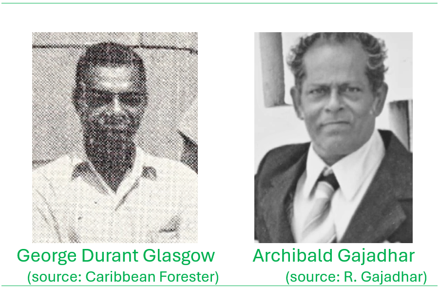
I recall that Archibald ‘Archie’ Gajadhar, the senior forestry officer working directly under Gabriel Charles, was able to drive his car all the way to the Paraiso area. Gajadhar would visit the location regularly to supervise the roadworks and also lend oversight to overall development of the commercial forestry programme. Archie had taken over from George Durant Glasgow, (senior forestry officer) who retired around that time. The tractor was also assigned to open up other agricultural roads however it developed mechanical problems with its hydraulics systems within two months. A smaller one was sent after about a year later to complete follow-on works. The D8, eventually rendered inoperable, was left to rot onsite at La Porte.
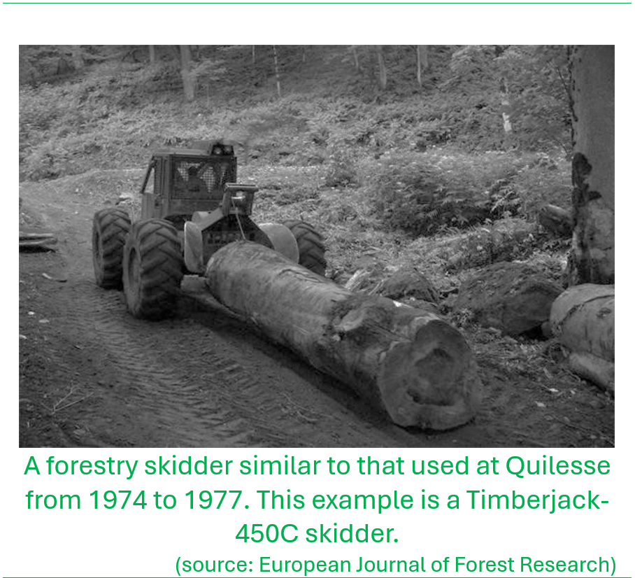
Under the CIDA forestry project a skidder was imported. The skidder was used to haul sawn logs overland to the logging bay or staging area that was located at La Porte, the site where the camping cabins are now located. By 1974/75, chainsaws started to be imported into the island and made the job of felling and converting the logs into boards for transportation much more efficient, compared to the traditional methods by axe or hand saw. Peter Gordon from Fond St Jacques was the main chainsaw operator in those days and did much of the work to convert the felled trees into boards which were inventoried and marked. Smaller trees that were thinned, were converted to fence pole material and sent to the split-fencing operation at Chassin in Northern Range. The truck from Timbershed would come up to Quilesse twice or three times a week to haul the sawn boards to the sawmill. The driver and myself as Range Officer, maintained corresponding records of the quantity and types of wood that was extracted from the forest.
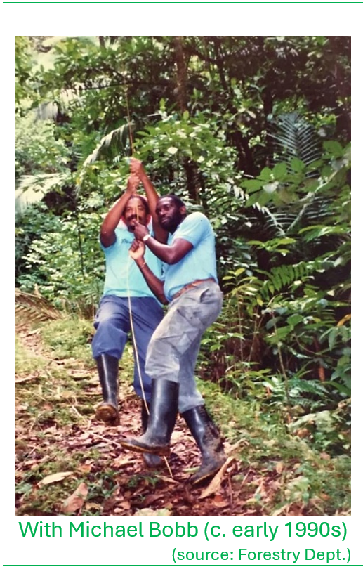
Henry ‘Belony’ Faustin was later trained as a chainsaw operator to support operations at Edmund Forest. Peter was transferred to La Porte to fell trees in support of the road clearing/construction operations. He did some felling to supply Timbershed until 1977 when he was transferred to support similar operations at Caille Des in the Northern Range. Two forestry officers from Soufriere Range, Michael Bobb and Julius James were deployed to Caille Des to oversee timber conversion operations and enrichment planting in that area during 1977.
The problem of squatters in the forest reserve
It was sometime in 1978 while I was staying at the Quilesse House, Augustin ‘Howe’ Isidore, who had walked across from Edmund Forest, woke me up at 5am with a directive from Gabriel Charles that he wants to urgently meet me and Felix ‘Jamsey’ James, a Range Officer also attached to Quilesse Range that day. On meeting first with Jamesy, he showed me a letter that was penned by the Prime Minister at the time, the late Sir John Compton. In summary the letter expressed dissatisfaction with the management of the forest resources, implying that the lands already under the jurisdiction of the Forestry Division seemed beyond its management capability, manifested by rampant squatting and destruction of forests, citing recent deforestation around Mt Grand Magazin. The letter further suggested that Forestry Division personnel were aiding and abetting the squatting due to inadequate enforcement. That period was during the peak expansion of the banana industry that was in fact facilitated by the government agricultural feeder road programme that opened up otherwise inaccessible landholdings to cultivation; and many of these areas were in close proximity to forest reserve areas. The statements in the letter directly implicated me as the officer in charge of the area and were very concerning.
Jamsey and I then proceeded to Vielle Litre to meet with Charlo who on arrival, wanted to ‘skin us’ for evidently allowing wanton deforestation at Grand Magazin. On reaching the site of the alleged infraction, we observed that there was indeed a large clearing in the forest we estimated to be over 5 acres, extending way up the slopes of the Grand Magazin mountain. It was however immediately apparent that these lands were not within the government forest reserve. I knew the forest reserve boundary line well as we had walked it twice recently and we showed Charlo the forest boundary marker pegs to dispel any doubt. Shortly thereafter Charlo responded to the Prime Minister to clarify the matter and allay the accusations.
In light of the growing problem with squatting and forest destruction within and in proximity to forest reserves and on steep mountainsides, in 1987 Charlo propositioned to Prime Minister John Compton to acquire for protection, all private lands adjacent to the forest reserves that were being destroyed, that were otherwise important for soil, water and wildlife conservation. The Prime Minister responded that he however will not oblige to place more lands under the Forestry Division considering the challenges with managing what was already under the Division’s control. To attempt to address these mounting concerns, Charlo issued a mandate to the forestry officers that all squatters were to be removed from the forest reserves by the early months of 1988.
Between April and May 1988, I commenced issuing charges for squatting in the forest reserves in violation of the Forest, Soil and Water Conservation Act, charging some 28 persons, the charge carrying an EC$500 fine and 3 months to vacate from the area, and failure to comply (with the magistrate orders) will result in a prison term. The areas we focussed on were at Des Cartiers and Fond Bwapen. Having issued the charges, the court case was called in June 1988 at the Micoud District Court with Gabriel Charles as the prosecutor and Indira Hariprasad as the presiding magistrate. In that proceeding, all the charges were upheld by the magistrate. This however immediately resulted in all 28 squatters to descend en-masse on John Compton’s constituency office at Mahaut in protest, with the magistrate’s orders in hand! In addition to these squatters, there was an additional group of 11 or 12 persons in the Belle Vue to Vve Ancelle area who were charged with squatting. They were also summoned to court in Vieux Fort in August same year. I recall that ahead of the proceedings the magistrate summoned Charlo privately and showed him a letter from the Prime Minister saying that she is to provide the persons with option of a mercy plea to allay the charges. In a follow-on action a Mercy Committee was established to pardon the squatters, that essentially thwarted further legal action by the Forestry Division.
This led to an alternate course of action where the squatters were induced to enter into a taungya system that allowed for continued operation of the squatter farm but with forest trees planted within to conserve the land; when the trees grew large enough, the squatter was assigned to another plot of land. However, in my estimation, this never really worked, and people essentially continued with their cultivations. Lands at Vve Voitire were Crown Lands adjacent to the forest reserve that were being rented but being severely degraded. It was during the forest boundary line survey (under the CIDA forestry project) when these lands (among others) were rationalized and incorporated into Quilesse Forest Reserve to assure protection.
The squatting in Quilesse were not the only cases that drew challenges for Forestry. There had been clashes with squatters in the field and I recall a well-known incident sometime in the 1980s when forestry personnel were patrolling a forest reserve area in the proximity of La Sorciere. That day Jerome Joseph alias ‘JB’ (who was the Division driver), carried a 12-guage shotgun into the field. The weapon had been issued to the Division to provide a deterrent and some measure of safety to the forest patrol team. Following the patrol, JB, in the company of Peter Vidal, the forestry officer from Dennery, decided to keep the rifle on his person and entered the nearby community. It seemed that this action drew the intense anger of a particular community member who accosted and beat him up, biting into his earlobe (and losing a small portion) and seizing the weapon from him!
The Crown Lands Department at that time had been placed under management authority of the Chief Forestry Officer; this was accompanied by a change in the post designation to ‘Chief Forest and Lands Officer’ (also by then the Forestry ‘Division’ had been upgraded to the status of ‘Department’). Under his authority, Charlo undertook to review the Crown Lands leasing system as it had consequences for squatting in the forest reserve. This was because landless people were for the most part, forced to seek out lands in the forest reserve to make a livelihood and logically it would be those people who should have first access to the Crown Lands, to legally occupy via formal lease. It was however known that many people who were leasing Crown Lands in fact already owned lands elsewhere. The land grabbing was triggered by the lucrativeness of the banana industry where people sought to acquire as much acreage as possible.
August Dantez, who had recently completed a stint as a demarcation officer under the Land Registration and Titling Project (LRTP) joined the Forestry Department as a Crown Lands Officer, joining Leo Dusauzay and Gregor Hall. Dantez was assigned to review all those Crown Lands lessees to determine whether they also had private lands. If persons who owned private lands (or had alterative lands to access) and were found to also be leasing Crown Lands, these leases would be allowed to run for their duration, thereafter not renewed, to be leased in favour of ‘verified’ landless farmers. Initially lessees had been short-term (one-year) but as banana expansion grew, leases were extended to up to 5 years that would allow people to service loans to further invest in their farming and other pursuits. Again, Charlo would be stymied in his efforts in at least one instance as I recall. The father of a particular parliamentarian at the time, owned more than 20 acres of land and yet was renting Crown Lands, placing him at odds with the policy that was being proposed. Charlo was called to account by higher-ups in the political directorate who advised him to desist from the policy, imposing further challenges in trying to rationalize management and protection of forested lands in the country.
Other forest range work
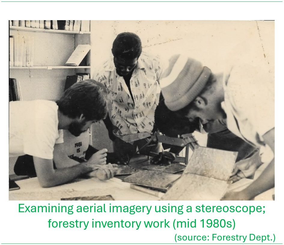
Under the CIDA forestry project in line with the requirements for improved management of the forest resources was the need to determine the compositional status of the forest reserve through a comprehensive forestry inventory. This inventory was carried out from 1982 and led by Pat O. Piitz a forestry inventory expert under the project. I was responsible for supporting the work in the Quilesse Range. Two crews of 8 to 12 persons each were assigned responsibility of inventorying trees along sample lines laid out in parallel, moving from mountain ridge to river, systematically counting trees on each side of the sample line, collecting data on species presence, frequency of occurrence and tree size (volume). The female forester staff in the inventory crews included Gloria Mortley and Alphia George who mainly did the compass and clinometer work for surveying out the sampling lines and measuring the tree heights. Since the work involved remaining overnight in the forest for durations of at least four days at a time, cooks were assigned to the crews to cook meals at breakfast and supper. By 1984 the work was completed.
In the mid-1970s Paul Butler had come to Saint Lucia to assist the Forestry Division in conservation efforts of the St. Lucia Parrot, known locally as the Jacquot. One of the priorities was to define an area within the forest reserve that would be formally designated with strictest protection status to assure survival of the species. This was considering the possibility that other areas with the forest reserve could be potentially used for other forest operations; hence this protected reserve would be a designated safe haven for the parrot. As part of the forest inventory exercise, Paul attempted to demarcate a proposed parrot protected area that he had drafted out on a map; however, the task of determining its alignment on the physical terrain was something more easily done on paper than in the field! The boundary alignment of the proposed reserve area (on paper) did not follow natural terrain features hence in some locations the proposed reserve limits were found to traverse impossibly inaccessible terrain including the slopes of Piton Troumassee. Michael Bobb, Theodore ‘Lester’ Jn Baptiste and Augustin Isidore from the Soufriere Range supported this effort. I recall one time when the crew had to rescue Paul from the forest after his legs completely cramped up and could not move. He had to be hog-tied to a stick and carried out on sturdy shoulders back to the resthouse…that was some sight!
An important part of the work in the range that was essential to monitoring encroachment by squatters was to ensure that the forest reserve boundaries were easily traceable. At the time when I joined Forestry, the forest boundary lines were cleared by private workers under contract. The amount that was paid to the workers was based on the linear footage cleared measured by chains; this had to be verified by the officer in charge of the range. I recall having to walk the boundary line with Emmaneul Theodore (Soufriere Range) at times emerging from the forest at dark when it would be almost impossible to see. I can’t recall the reason for the decision that did away with the private contractors, but the Forestry Department moved to the mode of using forestry staff workers to maintain the boundary lines. In any case with new workers who were brought on, I had them understudy Augustin given his intimate familiarity with the reserve boundary lines in the area. The entire forest reserve boundary was eventually demarcated and surveyed by Robert Harris under the CIDA forest project, a process that was completed by 1987.
Other memorable moments…
Getting caught in adverse weather and getting lost in remote areas of the forest were among experiences that as foresters we all encountered at some point. One such experience was sometime in 1974 when we were out tree stamping; that is marking trees for sale, and we were somewhere on the slopes Mt Gimie in the vicinity Mount Cochon. That day I was accompanied by Peter Felix aka ‘Officer’ from Fond St Jacques and we noticed that by mid-afternoon inclement weather was quickly closing in. In those days we did not have the sophisticated advance weather systems in place to warn us ahead of time, and communications were not as they are today with having mobile phones to get information; we just relied on signs in the forest in terms of whether the stream flow was rising or falling and how the skies looked. In spite of how ominous the skies looked, Felix insisted on taking his time to harvest some dasheen and breadfruit to bring home, instead of rushing out of the forest, against my cautions that it was getting late. The forests in the Quilesse area lie in the shadow of Mt. Gimie so that by 5pm especially under overcast skies, the light under the dense forest canopy diminishes quickly.
The skies finally opened up by about 4:00 pm with extremely heavy rain and we were seized by chill and darkness, so much so that we could barely see the trail ahead of us as we made our way out. Without flashlights, it was fortunate that Felix’s white dog, who had been with us, knew to follow the track back, and we ended up following him as he was just about visible in the darkness. On reaching the Quilesse Junction, the water level in the river had risen significantly, and the only hope of traversing, was to get a tree stem across, otherwise we would have had to remain in the forest in the dark and the rain. Felix was able to fell a small tree adjacent to the riverbank and guided it so it fell clear across to the other side. He cut a stick for me to help stabilize my balance across the tree over the raging Quilesse river below (main upper tributary of the Troumassee River). Completely soaked and cold we had to feel the rest of our way out of the forest well after 7:00 pm. Thinking back, one or both of us could have lost our lives for two breadfruit!
In another instance in 1976 if I recall well, Michael Bobb and I had had an appointment to inspect some trees to be harvested for sale. We had to make our way along a forest track that eventually took us to the top of Vielle Litre where we ‘stamped’ the tree identified for sale. As we proceeded onwards, heavy rain started to fall but we continued, following the track from Vielle Litre to Saltibus and thereafter down the Saltibus Road to a point to take another track to head toward a place called Lamaze. We got to a point along River Doree and Lamaz when we encountered a handful of kids who were trapped on the other side of the river and could not cross. The river was quickly swelling and was already at waist-high depth. Without help, the children will have been stranded in the outdoors for who knows how long. We ended up carrying them across the river on our backs one by one. At the end we were completely soaked having to remove our boots to drain out the water and walk all the way to Bath Nursery at Myers Bridge. I never knew where the kids were from, nor how they ended up there.
I remember a funny incident that involved a stand-off between August Dantez of the Crown Lands Department and Prime Minister John Compton over whether Prime Minister possessed a removal permit to transport freshly sawn wood planks he had in his pick-up truck. Back in the early 1970s the Forestry Division had planted Honduras Mahogany along the banks of the Troumassee River in the Mahaut area in order to protect the riverbanks from erosion. Some of the trees were planted on private lands, including on the property of the Prime Minister that bordered the river. Dantez, myself and a land surveyor, Stanislaus Auguste who was accompanying us, were driving along the Mahaut Road as Mr. Compton approached in his vehicle that was stacked with sawn mahogany boards. By law it was a requirement to apply for a ‘removal permit’ in order to transport timber on the public roadways as a means to track movement of timber products as part of the strategy to curb illicit felling of forests that was rampant in those days. Dantez, ever confident, flagged down the Prime Minister and demanded that he promptly presented his removal permit, adding that as an authorized officer under the Forest, Soil and Water Conservation Ordinance, he has the powers to seize the timber and impound his vehicle. As Mr. Compton cast his clearly annoyed stare, Dantez maintained face but eventually yielded with a friendly wave-off!

Mr Verneuil is a wealth of Forestry history!
The interference of ministers in Forestry staff enforcing regulations was disheartening to read.