Early categorization of the vegetation of Saint Lucia
The first attempt to classify the vegetation of Saint Lucia was carried out by John Stanley Beard. At the time, Beard was the Assistant Conservator of Forests based in Trinidad and Tobago. His work was published in 1949 in a report titled the Natural Vegetation of the Windward and Leeward Islands.
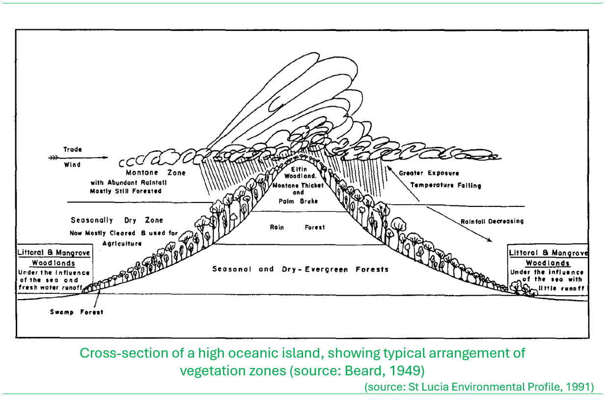
He assigned a seven-category classification to the island’s vegetation based on a characterization of a typical elevated oceanic island that receives orographic rainfall, where the vegetation composition is influenced by a pattern of relatively high rainfall in the interior mountains, declining towards the coastal regions. His diagram below illustrates the classification.
The following are the descriptions of the vegetation classes:
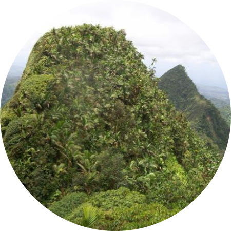
- Elfin woodland: Dominates the very highest elevation on the island mainly confined to the top of the Mt. Gimie ridge extending from Piton Troumassee to the Gimie summit. The vegetation is of low stature dominated by bromeliads, sedges and grasses (see description below by Graveson, 2009).
- Montane thicket: Dominates the steep slopes and ridges and the highest peaks of the island. The vegetation is typically stunted, shaped by the very windy conditions that sweeps across these high ridges. The main types of plants include terrestrial ferns, anthuriums, bromeliads, and epiphytes with thick coverage by mosses (see description below by Graveson, 2009).
- Lower montane rainforest: A more expansive vegetation class but confined to the lower elevations but within the rugged wet interior of the island. The canopy cover tends to be well developed on less steep slopes with a mix of various vegetation types of different statures. On the steeper terrain the forest may be lower, with a mix of ferns, mosses, ground anthuriums, vines, and epiphytes (see description below by Graveson, 2009).
- Rainforest: The dominant vegetation class across the wet interior of the island that is dominated by the gonnmyé and chatannyé tree association that can grow to substantial sizes especially within the sheltered deep upland valleys (see description below by Graveson, 2009).
- Secondary forest: This is a broad assemblage of vegetation types that is typically a mix of fragmented natural vegetation that has been previously disturbed by deforestation. This is often considered in some stage of regeneration or disturbance hence termed ‘secondary’ a vegetation type from what was once the ‘primary’ or original vegetation.
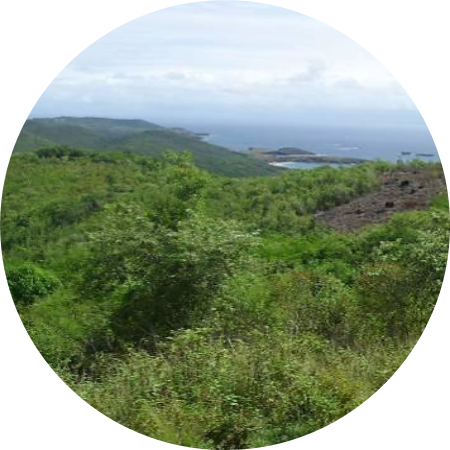
- Dry-scrub woodlands: This is the broad band of forest that generally occurs along the coastline and lower elevations that has evolved under the drier rainfall regime. In areas adjacent to the coast, the vegetation can be dominated by deciduous trees that lose their leaves in the dry season and cactus.
- Savanna and grazing land: Typically dominates landscapes in the lowest elevations along the coast, interspersed with the dry-scrub woodlands that have been historically cleared to create livestock pastures. These areas are dominated by grasses.
The following are illustrations from Beard’s 1949 study, extracted from the St. Lucia Environmental Profile (1991).


Graveson (2009) noted that John Beard’s work in the 1940s and 1950s produced a system of classification of vegetation based on climactic physiognomy, floristics and habitat for South America and the Caribbean that is still widely used and respected today. He noted further that Beard’s approach was very useful because it revealed approximately how the natural vegetation would have looked before humans arrived, and the relationships between various vegetation types.
Holdridge Natural Life Zone Mapping of Saint Lucia
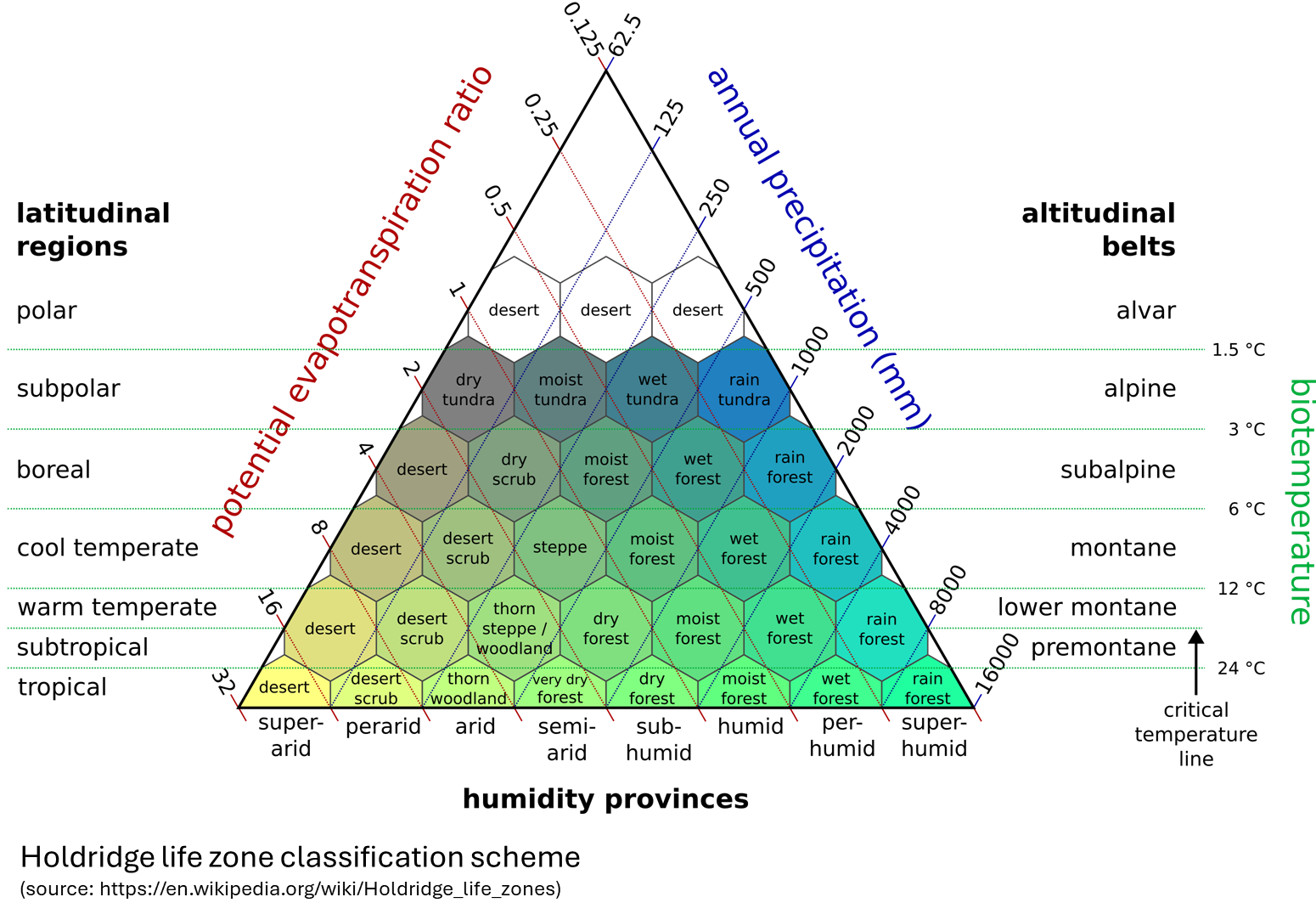
The Holdridge life zone system of vegetation classification, developed by Leslie Holdridge in 1967 is a methodology that predicts the type of ‘vegetation assemblage’ that will naturally occur across a landscape based on the prevailing temperature, rainfall and potential evapotranspiration regimes. Other elements incorporated into the scheme include humidity provinces, latitudinal regions and altitudinal belts. The system has been widely applied at the global scale.
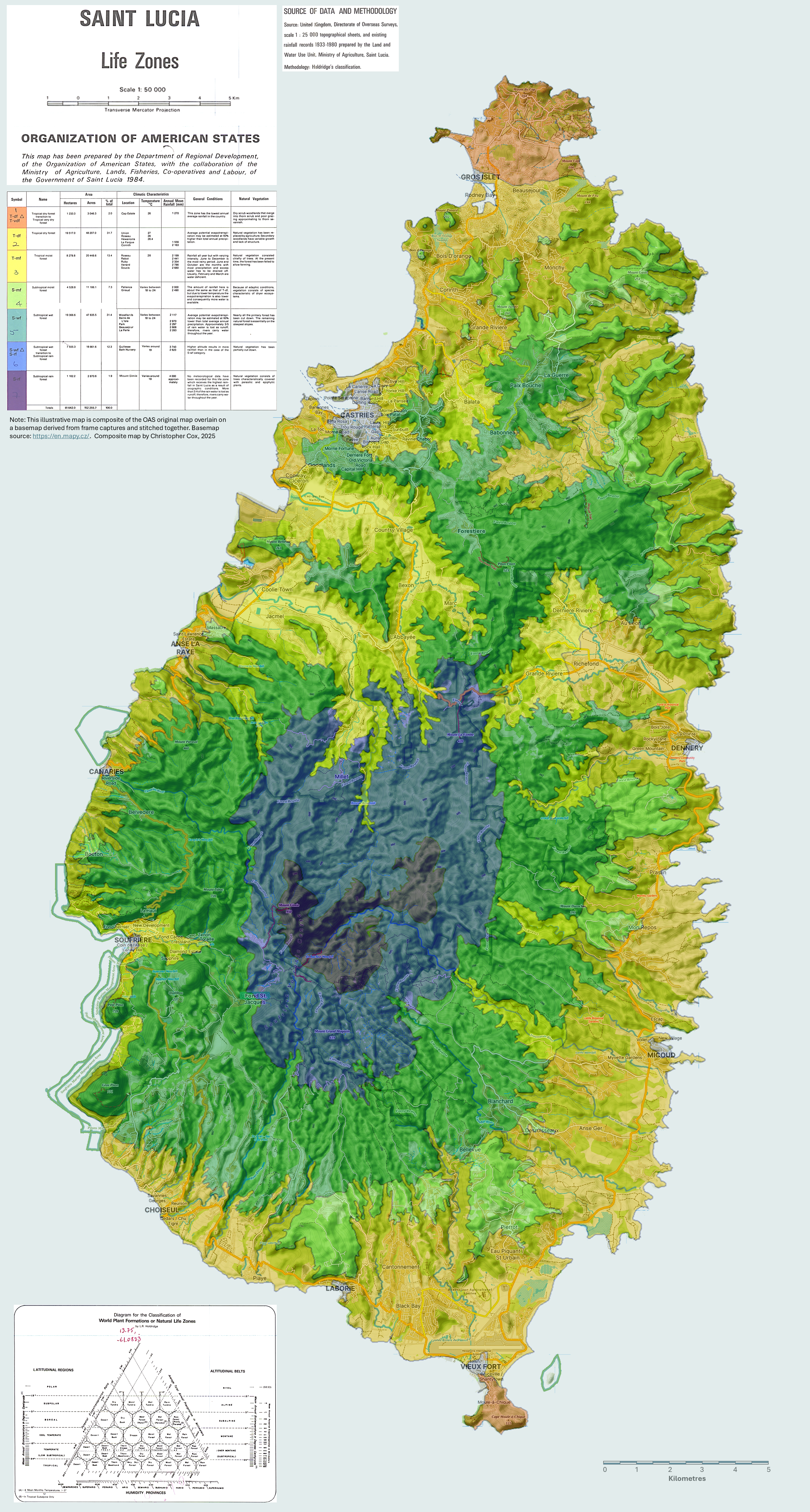
In 1984 the Organization of American States (OAS) developed a 1:50,000 scale mapping series for Saint Lucia that included a Natural Life Zone map based on the Holdridge system of classifying biogeoclimatic zones in a standard nomenclature, to characterize the vegetation.
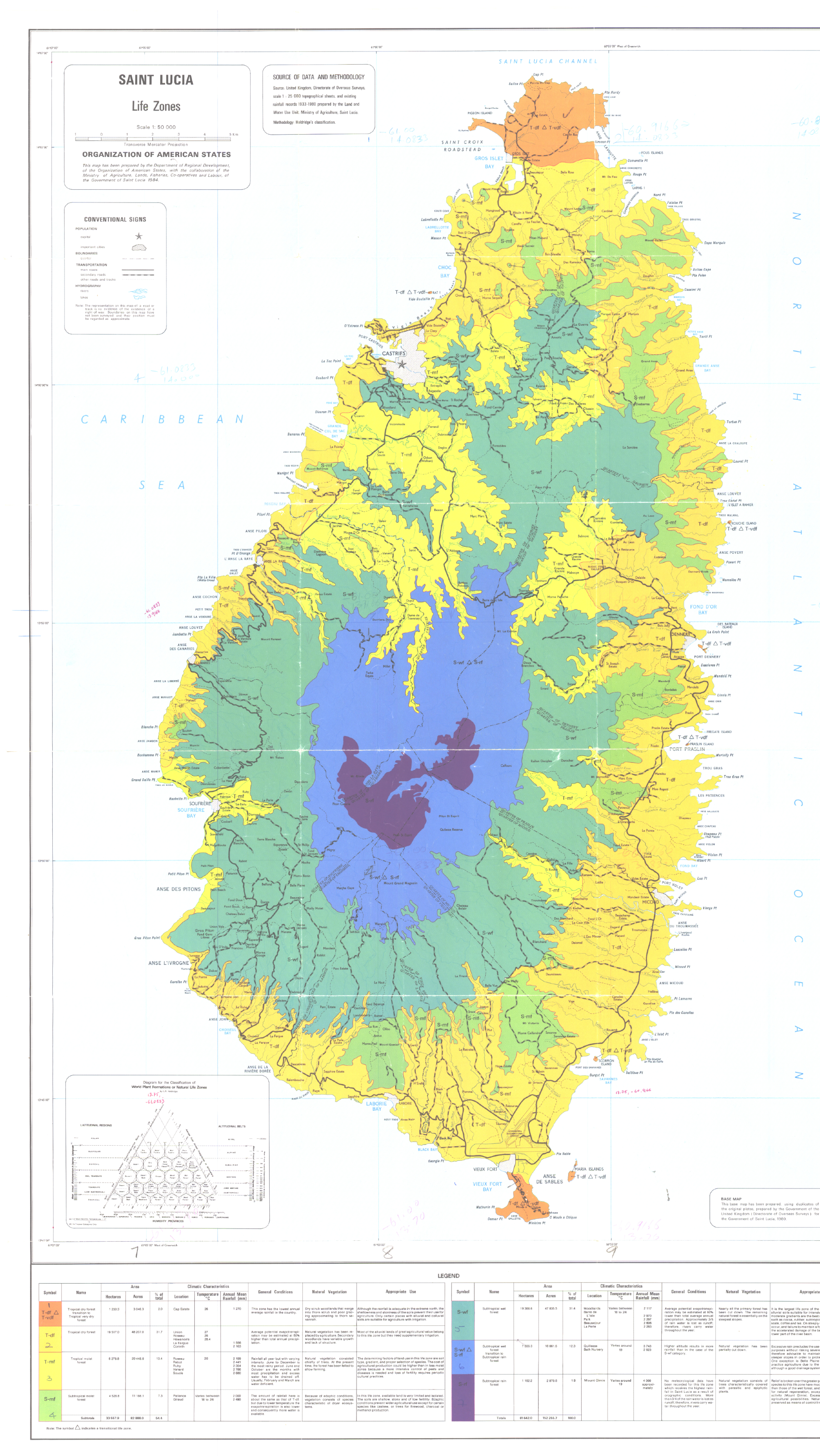
Five life zones and two transitional life zones were defined for the island; (1) Tropical dry forest, (2) Tropical dry forest transition to Tropical very dry forest, (3) Tropical moist forest, (4) Subtropical moist forest (5) Subtropical wet forest (6) Subtropical wet forest transition to Subtropical rain forest and (7) Subtropical rain forest1. The composite map (original OAS mapping overlain on a basemap) below illustrates the life zones.
Click or tap on the map to view in high-resolution
1 Saint Lucia Natural Resources and Agricultural Development Project – Studies and Proposals for the Implementation of a Land Registration Programme https://www.oas.org/dsd/publications/Unit/oea36e/oea36e.pdf
Refining the Life Zone vegetation classifying approach
Cornelius Isaac and Charles Bourque applied computer-assisted artificial neural network (ANN) technologies to assess ecosystem distribution on the island in an effort to develop an improved ecological classification using Holdridge’s system of natural life zones. In 2001 they published a paper Ecological Life Zones of Saint Lucia based on the analysis.

The main inputs for classifying life zones were a 25×25 metre digital elevation model (DEM) of Saint Lucia, the mean annual temperature and annual total precipitation. The approach employed the generation of a predictive rainfall model based on training iterations of the ANN based on variables of longitude, latitude and elevation. The potential evapotranspiration ratio was computed based on the modeled annual precipitation and the biotemperature. Three complete and three transitional life zones were identified as occurring on Saint Lucia as shown in the mapping that was derived from the analysis.
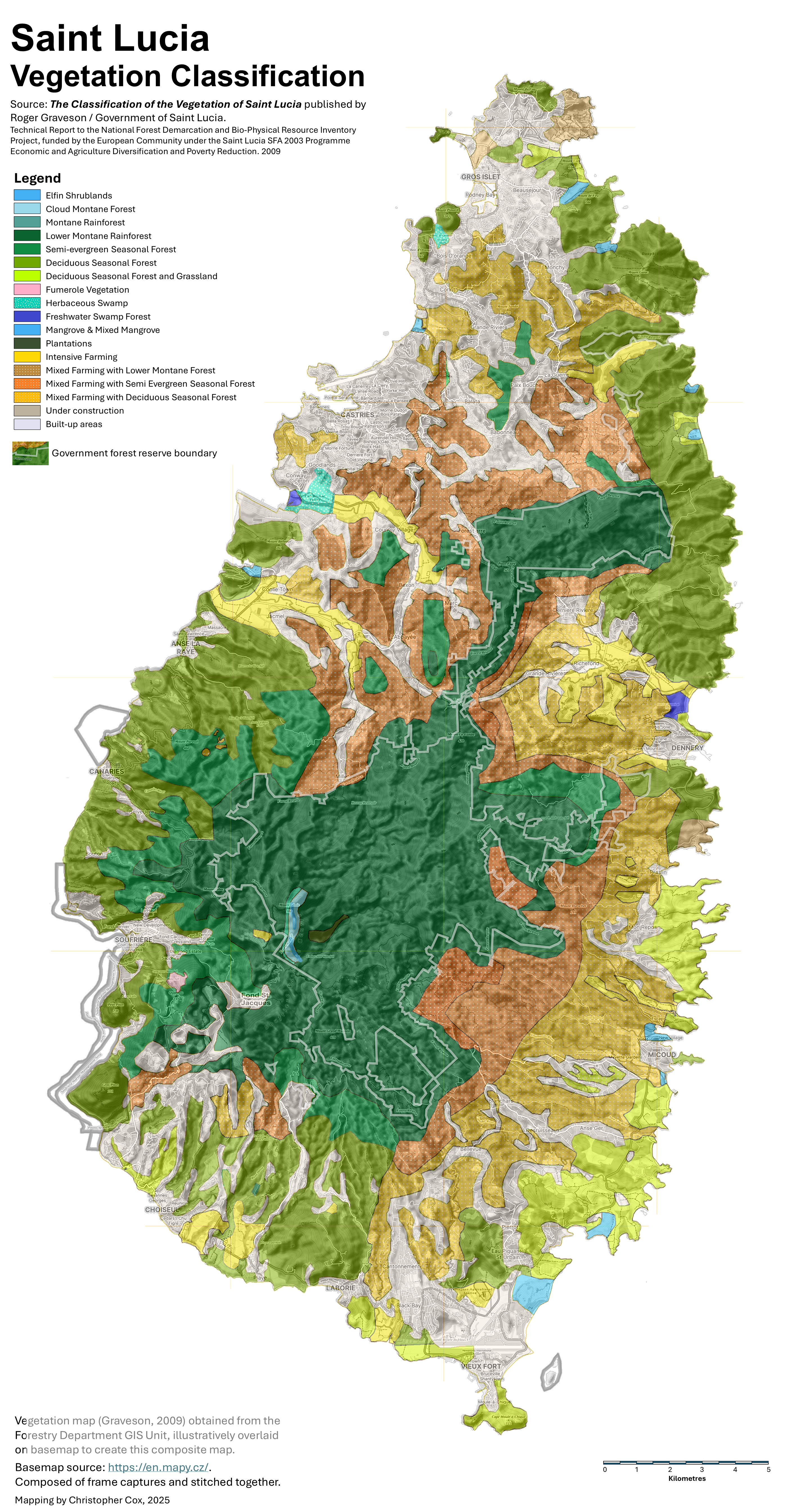
Current vegetation classifiction scheme for Saint Lucia
The latest vegetation classification scheme was financed by the European Union under the 2003 tranche of the Special Framework of Assistance (SFA-2003). This effort was embedded in a broader programme of assistance to the Government of Saint Lucia to address the challenges of land degradation and impacts to the island’s water resources. Under the SFA-2003 a National Forest Demarcation & BioPhysical Resource Inventory was undertaken, implemented by the Finnish Consulting Group (FCG) International Ltd in collaboration with the Saint Lucia Forestry Department. The project commenced in July 2008 and began the Final Phase, in the fourth quarter of 2009.
Among the studies carried out under the National Forest Demarcation & BioPhysical Resource Inventory was a revisiting of the systems of classification of vegetation types of the island. The aim was to produce an accurate and easy-to-use classification system based on island-wide vegetation surveys to collect full species information and environmental data. The new classification is anticipated to contribute toward improved forest resources management in the country and inform recommendations for conservation particularly of threatened vegetation classed and species therein.
The Classificaton of the Vegetation of Saint Lucia was based on a combination of field studies and satellite image analysis. Some two hundred plots were surveyed, each 20 metres in radius, covering a wide range of elevations in all parts of the country. Both floristic and biophysical data were recorded within every plot.
The lead investiagtor was Roger Graveon, supported by a team that included Melvin Smith, Field Assistant, Jennifer Daltry, Conservation Biologist, Bob Tennent, Project Leader, Vijay Datadin, GIS & Data Management Specialist, Matthew Morton, Critical Habitats Specialist and Rebecca Rock, GIS Management Specialist with the Forestry Department.

The proposed classification scheme defined three broad categories (1) Natural Forest, (2) Non-Forest and (3) Non-natural Forest.
Natural Forest
- Cloud Montane Rainforest
- Montane Rainforest
- Lower Montane Rainforest
- Semi-evergreen Seasonal Forest
- Deciduous Seasonal Forest
- Freshwater Swamp Forest
- Mangrove
- Littoral Evergreen Forest and Shrubland
Non-Forest
- Elfin Shrublands
- Herbaceous Swamp (seasonal or permanent)
- Aquatic Herbaceous Vegetation
- Littoral Rock and Cliff Vegetation
- Littoral Unconsolidated Sand Vegetation
- Littoral Scrub, including Cacti
- Fumarole Vegetation
- Grassland, with or without a few trees or shrubs
Non-natural Forest
- Tree Plantations
While drawing on the Holdridge life zone nomenclature, this vegetation classification incorporated land use influences that would otherwise modify the naturally occurring vegetation assemblages. The map below shows the proposed vegetation classification.
This map was created by an ‘illustrative overlay’ of the map in the report (see page 57; map re-coloured for this display) over a basemap image composed from imagery extracted from https://en.mapy.cz/. The overlay was not precise but gives a reasonable approximation of the alignment of the vegetation types with the terrain. An attempt will be made to improve the visual quality of the final mapping.
Click or tap on the map to view in high-resolution
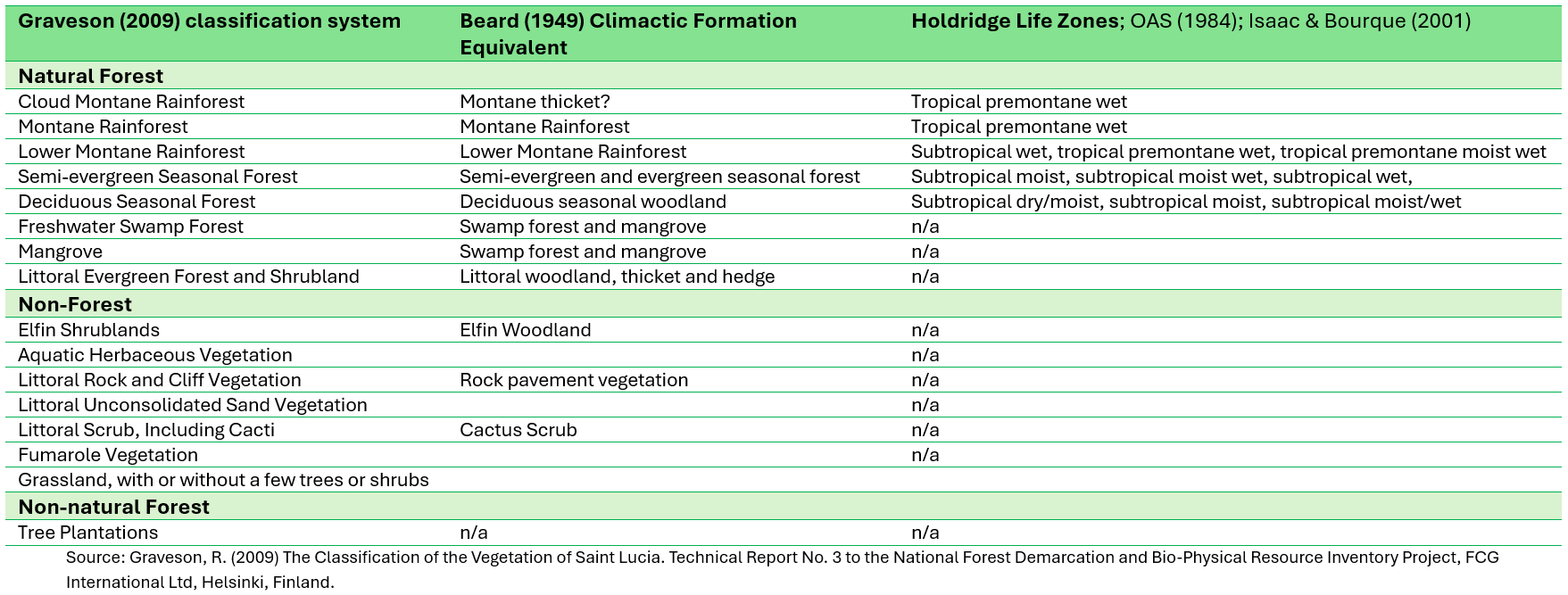
Graveson presented a comparison between the new vegetation classification against the other vegetation classification approaches applied for Saint Lucia. The following is an extract for those presented in this write-up:
The following are descriptions of the various natural vegetation classes defined under the Classification of the Vegetation of Saint Lucia Project. All the descriptions and photos were drawn directly from the report. The links to the scientific names of the trees were for the most part content available on Wikipedia, and iNaturalist, to the genus level and where available to the species level.
Elfin Shrubland
In the windiest spots on the Mount Gimie/ Troumassée ridges and peaks, at an elevation above 700 metres, a shrubland vegetation class dominates. The canopy is up to 2m tall, typically with Lobelia santa-luciae, a Saint Lucian endemic. Cloud and mist cover, with heavy rainfall, is predominant with occasional short periods of sunshine. Relatively few species are found in this vegetation type: mainly a mixture of bromeliads, sedges and grasses and shrubs, with many Lesser Antillean endemics.
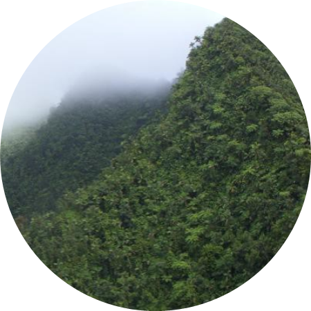
Cloud Montane Rainforest
This vegetation class is found on the high summits of the Mount Gimie range, including Piton Troumassée (although not in the most windy spots), at an elevation of 700m or higher and possibly the eastern interior end of Mount Tabac ridge and a small area on the western end of the La Sorciere ridge. The canopy is about 8m high with occasional much taller trees of Freziera undulata. Terrestrial ferns, anthuriums, bromeliads, and epiphytes are very common; moss cover is often several centimetres thick. Cloud and mist cover, with heavy rainfall, is predominant, with only occasional and short periods of sunshine. Some species found in Montane and Lower Montane Rainforest are also found here, e.g. Byrsonima trinitatis (bwa tan wouj) and Micropholis guyanensis (fey dowé). However, other species appear almost unique, e.g. Podocarpus coriaceus (lowyé woz), Freziera undulata, Schleffera attenuata (fijé di mon), Miconia globulifera and Guettarda crispiflora. The steeper slopes are often covered in monotypic stands of small, stocky Prestoea montana (palmis).
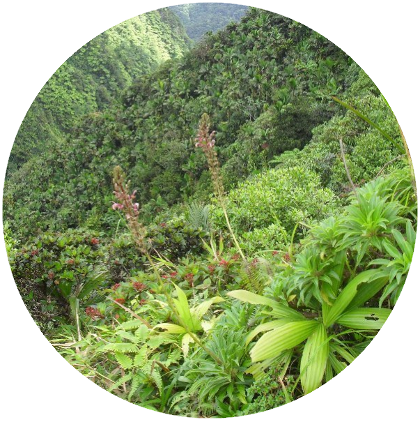
Montane Rainforest
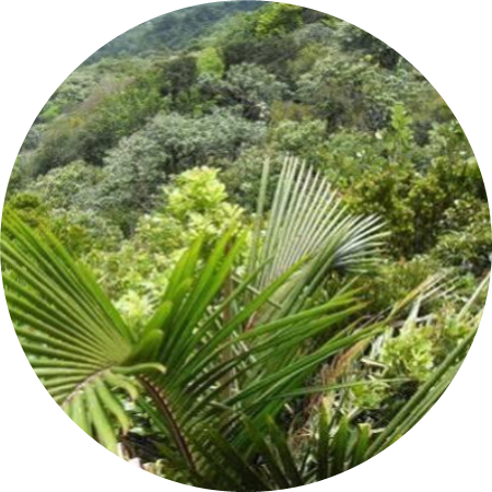
Montane Rainforest is on the western side and sheltered eastern slopes of the Mount Gimie Range, including Piton Troumassée, above 650m. Slopes are extremely steep, rainfall is very heavy, there is little wind and landslides are very common. The steepest areas are covered with tree ferns and palms, with canopy height of about 4-6m, with some scattered taller trees on slightly less steep areas. The dominant species are Prestoea montana (palmis) and Alsophila and Cnemidaria tree ferns. The spiny Alsophila imrayana is a good indicator of this forest class. On slightly less steep slopes, trees typical of higher elevation Lower Montane Rainforest such as Byrsonima trinitensis (bwa tan wouj) and Micropholis guyanensis (fey dowé) can reach 8m tall. Terrestrial ferns, anthuriums and bromeliads are very common and there is a large quantity of slowly rotting organic material.
Lower Montane Rainforest
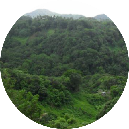
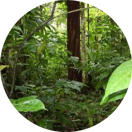
Lower Montane Rainforest is a suite of many different types of forest where the canopy height can vary from 4m to more than 45m; canopy cover is often quite complete on gentler slopes, but broken on steep slopes; ferns, mosses, ground anthuriums, vines, and epiphytes vary from absent to abundant; trees with buttresses and prop roots are present in some areas and absent in others. At ground level, it varies from humid, quite dark and still, to rather breezy and bright.Trees are evergreen because there is no water deficit most years in any month. In general, trees of all heights are found, without clear divisions into separate canopy layers. Lauraceae, particularly Ocotea eggersiana (lowyé ti fey) and Ocotea leucoxylon (lowyé mabwé) are common, along with Ormosia monosperma (dédéfouden) and with smaller trees such as Faramea occidentalis (ti kafé) Gymnanthes hypoleuca (bwa sadinn) and Eugenia coffeifolia. Also common are trees such as Myrcia deflexa (bwa kwéyòl) and Guapira fragrans (mapou) which are also found in other vegetation classes. Sterculia caribaea (maho kochon) is often the most common tree. Away from the edge of the forest, on comparatively gentle slopes without much wind, occasional very tall trees, reaching 45m, are found among the main 30-m canopy. This distinctive forest is often called the Dacryodes excelsa (gonnmyé)–Sloanea caribaea (chatannyé) alliance. Higher slopes, which are usually steeper, tend to have a more vines, moss, ground ferns, ground anthuriums and epiphytes.
Semi-evergreen Seasonal Forest
Semi-evergreen Seasonal Forest occupies the zone between Deciduous Seasonal Forest and Lower Montane Rainforest. It is characterized by upper canopy trees with rather thin, often broad, and quite often compound leaves, which may lose some, but not all, of their leaves during a dry spell. There are no, or very few, epiphytes, ground ferns and mosses. Elevation ranges from almost sea-level in ravines to the summit of Gros Piton. In comparison with Deciduous Seasonal Forest, this forest class has a higher canopy and greater canopy cover and trunks with a greater girth. It occurs in less windy areas, and generally at a higher elevation. This rare forest has almost been completely destroyed for agriculture: most of the areas currently occupied by banana plantations would have had Semi-evergreen Seasonal Forest. Semi-evergreen Seasonal Forest is now mainly found in small pockets among fields, by roads and as a thin line along rivers, and is virtually all secondary, with the possible exception of the upper third of Gros Piton, Mount Parasol and the northern slope of Mount Souf. Typical species of Semi-evergreen Seasonal Forest include Cordia sulcata (sip blan), Guazuma ulmifolia (bwa lonm), Inga ingoides (kakoli), Daphnopsis americana (maho pimen), Lonchocarpus heptaphyllus (Savonnèt gwan fey).
Deciduous Seasonal Forest
This vegetation class covers large areas in Saint Lucia from the coast to the summit of Petit Piton, although it is virtually all secondary and much of it degraded. This class is defined as deciduous because the taller trees tend to lose all their leaves in most dry seasons, although the smaller trees and shrubs are evergreen. Its overall appearance during a normal dry season is of a more or less leafless canopy. The main canopy of dominant trees such as Bursera simaruba and Lonchocarpus punctatus are deciduous and give these slopes a barren appearance during the dry season. However, the understory trees and shrubs, such as Myrtaceae and Celastraceae, keep their leaves. The largest area of Deciduous Seasonal Forest is found in the north-east of the island, between Cas en Bas and Dennery. It is virtually all secondary and much of it shows signs of recent disturbance. Large areas of Deciduous Seasonal Forest are also found on the Caribbean coast, particularly from Anse La Raye to the Bouton area, Soufriere. In general, they are moderately to severely degraded, with only the ravines holding a more natural forest. Anse La Liberté is now a protected area and the forest is slowly recovering.
Freshwater Swamp Forest
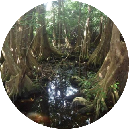
This vegetation class, like mangrove, is independent of direct rainfall and more dependant on edaphic (soil) water and occurs in flat areas close to sea-level, with a permanent or seasonal freshwater flow and no inflow of salt water. Trees are evergreen and there is a tendency for more or less monotypic (single-species) stands to form. This class varies from the permanently muddy and occasionally inundated swamp redwood forest beside rivers with a permanent flow of water, to forest on flat areas behind beaches that rely on seasonal creeks to maintain the water table. The classic Freshwater Swamp Forest is swamp redwood forest. The magnificent Pterocarpus officinalis, with its sinuous plank buttresses, forms monotypic stands. Formerly, this forest would have covered large areas in the flood plains of large rivers, such as Cul de Sac, Roseau and Fond D‟Or, but much of it has been destroyed and replaced by banana plantations or Herbaceous Swamps. Relics remain at Fond d’Or (north end) and Cul de Sac (beside an old rubbish dump). A more pristine area remains at Ger River, Micoud, between the bridge on the highway and the sea. Small stands can sometimes be seen along estuaries of smaller rivers.
Mangrove
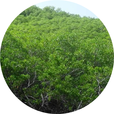
Mangroves contain four tree species and are mainly on the Atlantic coast. Rhizophora mangle (manng wouj, red mangrove) is found usually in standing brackish water and sends out prop roots from its trunk and branches which arch down to the ground. Avicennia germinans (manng salé, black mangrove), is found in muddy areas or shallow surface brackish water, often in quite extensive stands (A. schaueriana is much rarer, but occupies a similar habitat). The ground beneath Avicennia trees has clusters of upward-pointing aerial roots (pneumatophores). Laguncularia racemosa (manng blan, paltivyé, white mangrove) also forms extensive stands, usually further inland than Avicennia germinans. On the edge of the mangrove, several mangrove-associated species are found. The most important are Conocarpus erectus (paltivyé wouj, button wood) and the shrubby vine Dalbergia ecastaphyllum. Much of Saint Lucia’s mangroves have disappeared and the rest are still being damaged, sometimes by clearing, more often by drainage changes.
Littoral Evergreen Forest and Shrubland
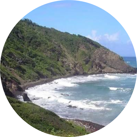
Behind sandy beaches, rocky cliffs and pavements, an evergreen forest or shrubland is found, especially on the Atlantic coast. The harsh conditions caused by wind, salt-spray, often a thin soil and a water deficit even during most of the wet season, favour an evergreen arborescent flora with thick leathery leaves. This vegetation class takes the form of wind-sculptured low shrubland, sometimes reaching 100 metres inland. Although often one metre tall or less, it may contains dwarfed trees with substantial trunks. Typical species include Tabebuia pallida / heterophylla (white cedar, poyé). Coccoloba uvifera (wézen, siwiz, sea grape) is commonly present in this vegetation class.
Herbaceous Swamp (seasonal or permanent)
Seasonally or permanently muddy or flooded areas with a mainly herbaceous cover, along with some shrubs, and possibly an occasional tree. Most Herbaceous Swamps are not natural, but result from the clearing of forest in flat areas. The biggest areas are in the Cul de Sac and Fond D’Or river valleys, where swamp redwood forest has been cleared. Grasses and sedges dominate, often with Acrostichum danaeifolium ferns. Neglected ditches and ponds can become small Herbaceous Swamps.
Aquatic Herbaceous Vegetation
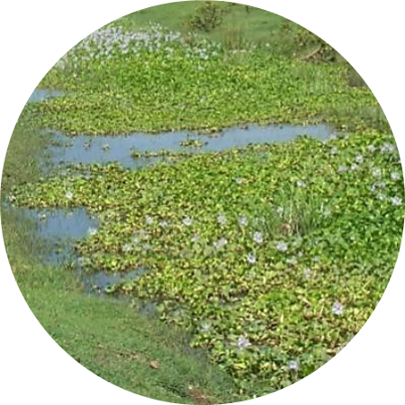
This class includes Marine Herbaceous Vegetation, that occurs in coastal waters. Sea-grasses are not true grasses, but rooted, submerged flowering plants. They form ecologically important beds in shallow marine waters. The other group is Freshwater Herbaceous Vegetation, that comprises several species that float on freshwater including the alien invasive water hyacinth.
Littoral Rock and Cliff Vegetation
Mainly herbaceous, often succulent, low vegetation found on coastal cliffs and the flatter rocky areas behind them. More common on the Atlantic coast, where conditions are extreme with strong winds, long periods of drought, fierce sunshine and very little or no soil. These areas are home to a quite varied, special flora of low herbs, often interspersed with the Turk’s Cap cactus (Melocactus intortus).
Littoral Unconsolidated Sand Vegetation
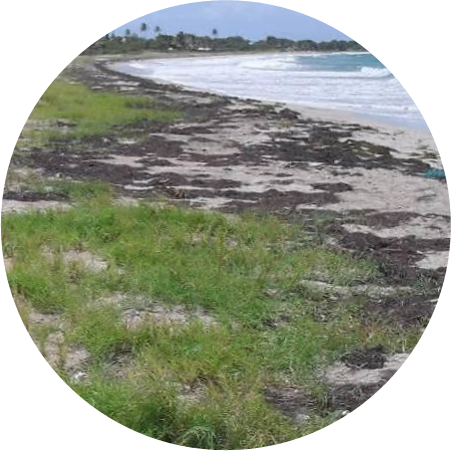
Mainly herbaceous, salt-tolerant vegetation, growing on loose sand on beaches and adjacent low dunes. The pioneer species are trailing rooting herbs, with succulent species slightly further inland. In some locations, shrubs appear on low sand dunes a few metres inland of high tide. Sporobulus virginicus and Ipomoea pescaprae are the most common of the pioneer plants. Shrubs may develop a few metres above the high tide mark, where the sand is still more or less loose or slightly consolidated in small dunes. This is best observed on the southern half of Anse des Sables, Vieux Fort Some rare species, such as Corchorus hirsutus and Sophora tomentosa, are also found here.
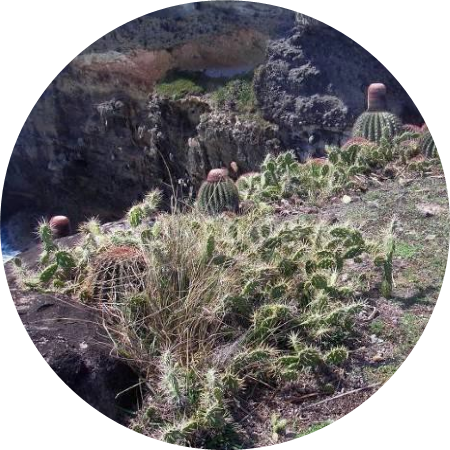
Littoral Scrub, With or Without Cacti
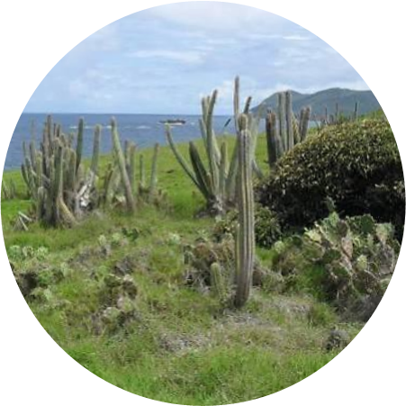
This type of vegetation is found in a narrow zone between littoral rock and cliff vegetation and Deciduous Seasonal Forest or Littoral Evergreen Forest. It consists of shrubs, cacti and sometimes grassy spaces.
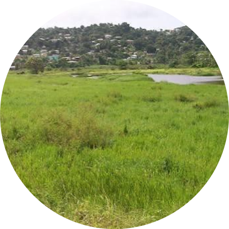
Grassland (with or without a few trees or shrubs)
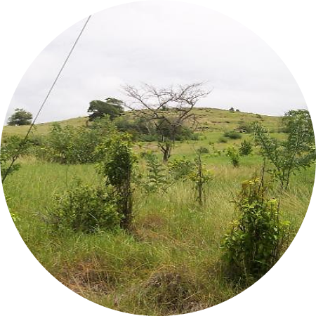
Open grassy areas are probably not a natural vegetation class in Saint Lucia, except perhaps as small patches in rocky coastal cliffs and pavement. These are generally open areas covered mostly by grasses or sedges, but other herbs and low shrubs are also present. Individual trees or small clumps of trees and taller shrubs may also be present. This vegetation class is most common near areas of Deciduous Seasonal Forest and is usually a result of extreme disturbance to that forest class. Fires and other continual disturbance of Deciduous Seasonal Forest produces degraded “grassy‟ areas (including sedges) with some shrubs and trees. Abandoned gardens in wetter areas can temporarily take on this form, but quickly develop into secondary forest. The Choiseul to La Pointe area also has extensive tracts of Grassland on what was originally Deciduous Seasonal Forest. This has in some cases been caused by clearance for farming and subsequent abandonment.
Fumarole Vegetation
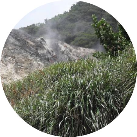
This is a rare acid-tolerant class confined to the Sulphur Springs, especially on the slope of Mount Souf. It is dominated by ferns about 2m tall and a bromeliad, with widely-spaced trees. Only plants that can tolerate very acidic conditions can survive here. The most tolerant is Pitcairnia angustifolia. This, and two fern species, Blechnum serrulatum and Pteridium arachnoideum, dominates the hillside along with planted, and now self-seeding, Caribbean pines and Clusia plukenetii (awali).
Tree Plantations
This class has mature trees that have been planted in an organized manner, mainly in and around the forest reserve, with smaller wild trees and shrubs growing between them. Substantial areas of the rainforest reserves have been replanted with Talipariti elatum (blue maho), Swietenia macrophylla (Honduras mahogany), Eucalyptus, Gmelina arborea and Pinus caribaea (Caribbean pine). The natural forest has been allowed to grow through.
Contributors

Christopher Cox (lead author), Forestry Officer, Saint Lucia Forestry Department, 1985-2002
Roger Graveson, Floral researcher, Saint Lucia, 19xx-present
Would love to hear from you! Leave your comments below!