PAGE UNDER ACTIVE DEVELOPMENT – DO NOT CITE
The early days; land exploitation and consequences
It is known that the landscape of Saint Lucia has undergone significant changes over the centuries since the island was initially colonized. As with all the possessions in the Caribbean in the colonial days, Saint Lucia’s land resources were exploited for the cultivation of sugar cane, through the forced labour atrocities of slavery. The French introduced sugar cane cultivation to Saint Lucia in 1764, expanding the holdings that were already established in neighboring Martinique, triggering the large-scale transformation of the island’s landscapes. The French offered free grants of land to anyone who would come to settle. The first sugar estates were established in the Vieux Fort area, with large plantations gradually taking over most of the flat valleys, including the plains around Vieux Fort, and much of the northern part of the island. By 1775, there were 802 estates. Although sugar cane was the main crop, cotton, tobacco and spices were also grown. In those days Saint Lucia’s forests were already being cut down to export timber to Barbados and Martinique. (BushTalk, Book 1, The Forest and Book 8 People and Places).
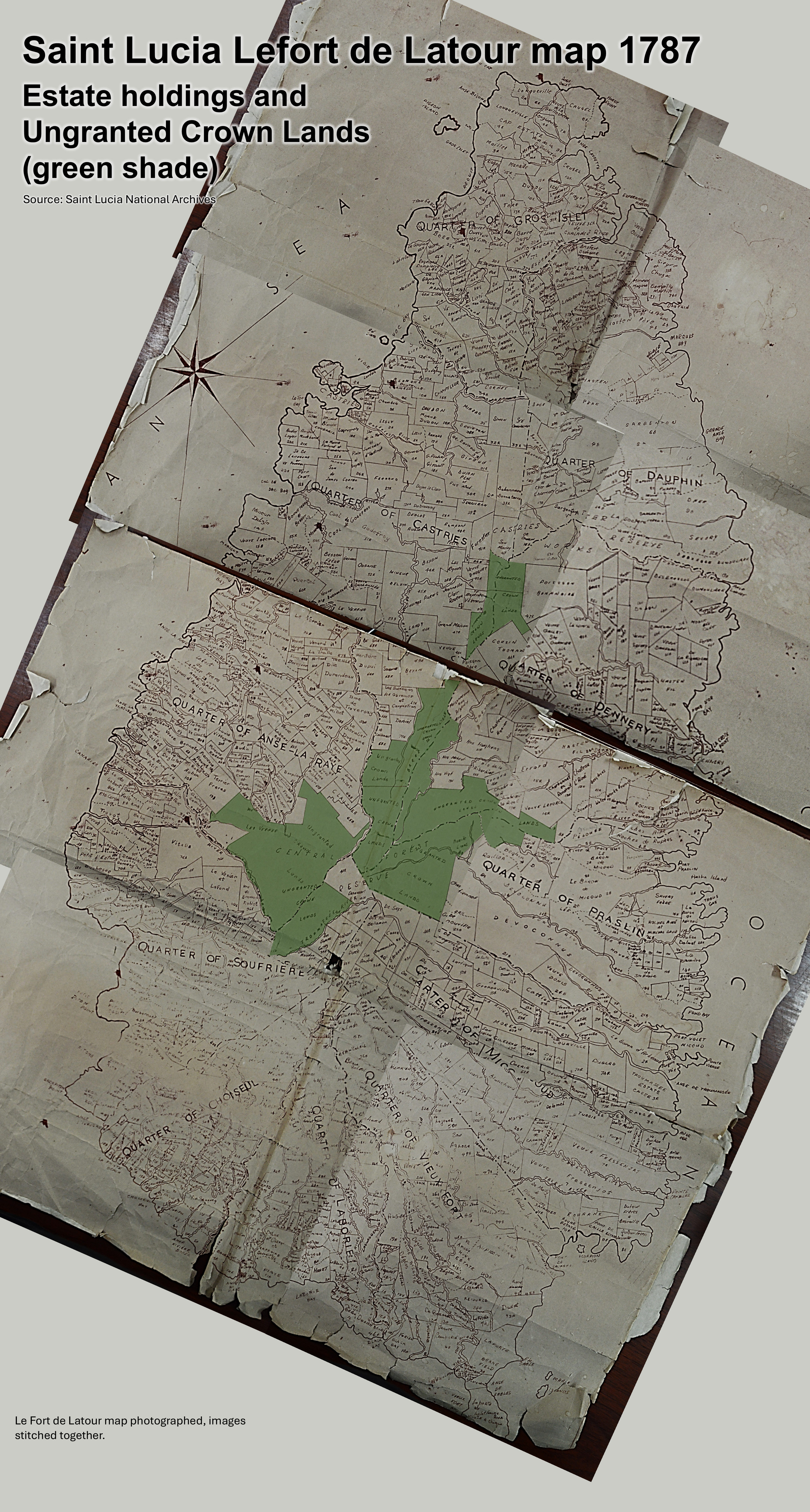
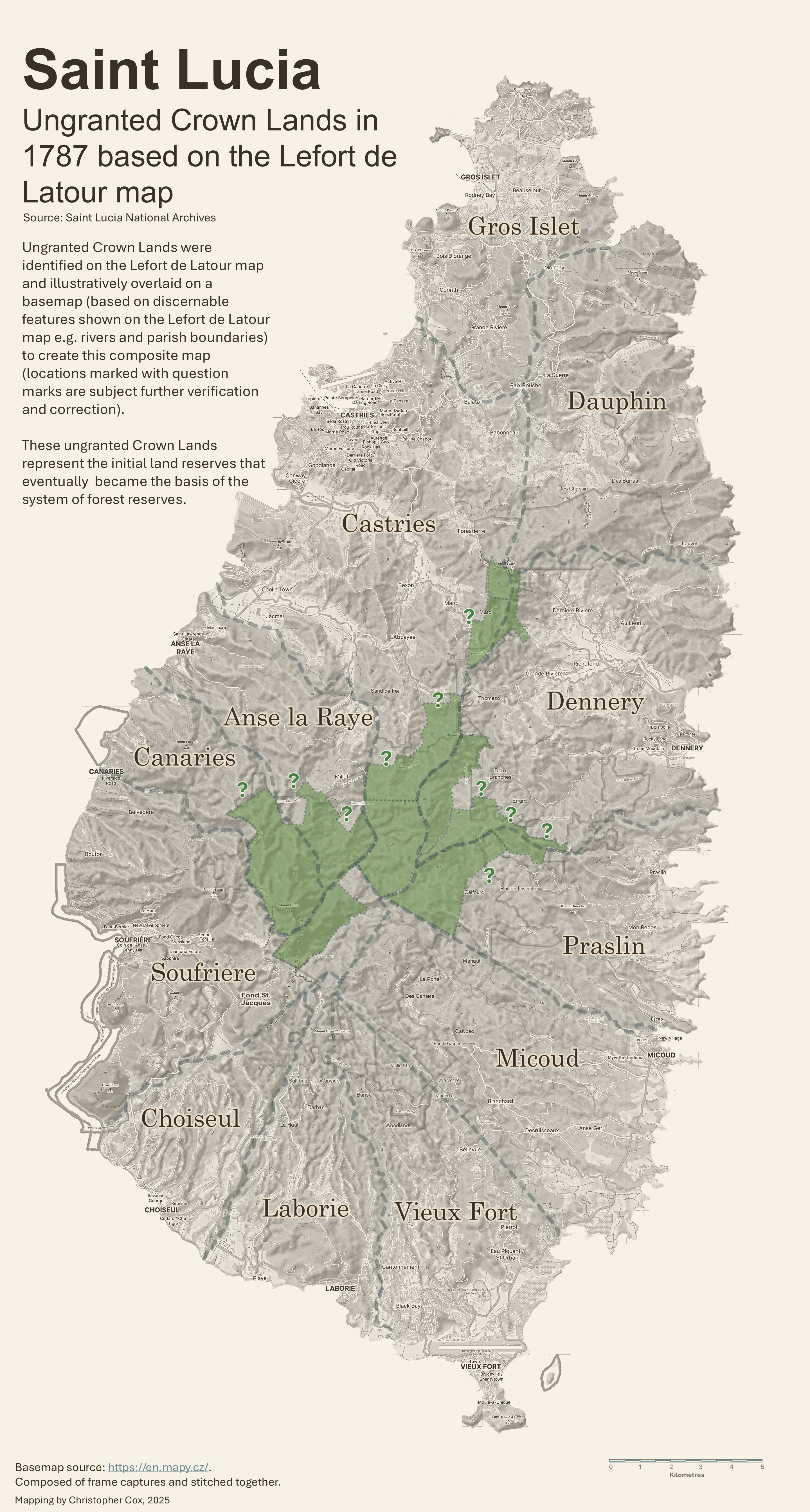
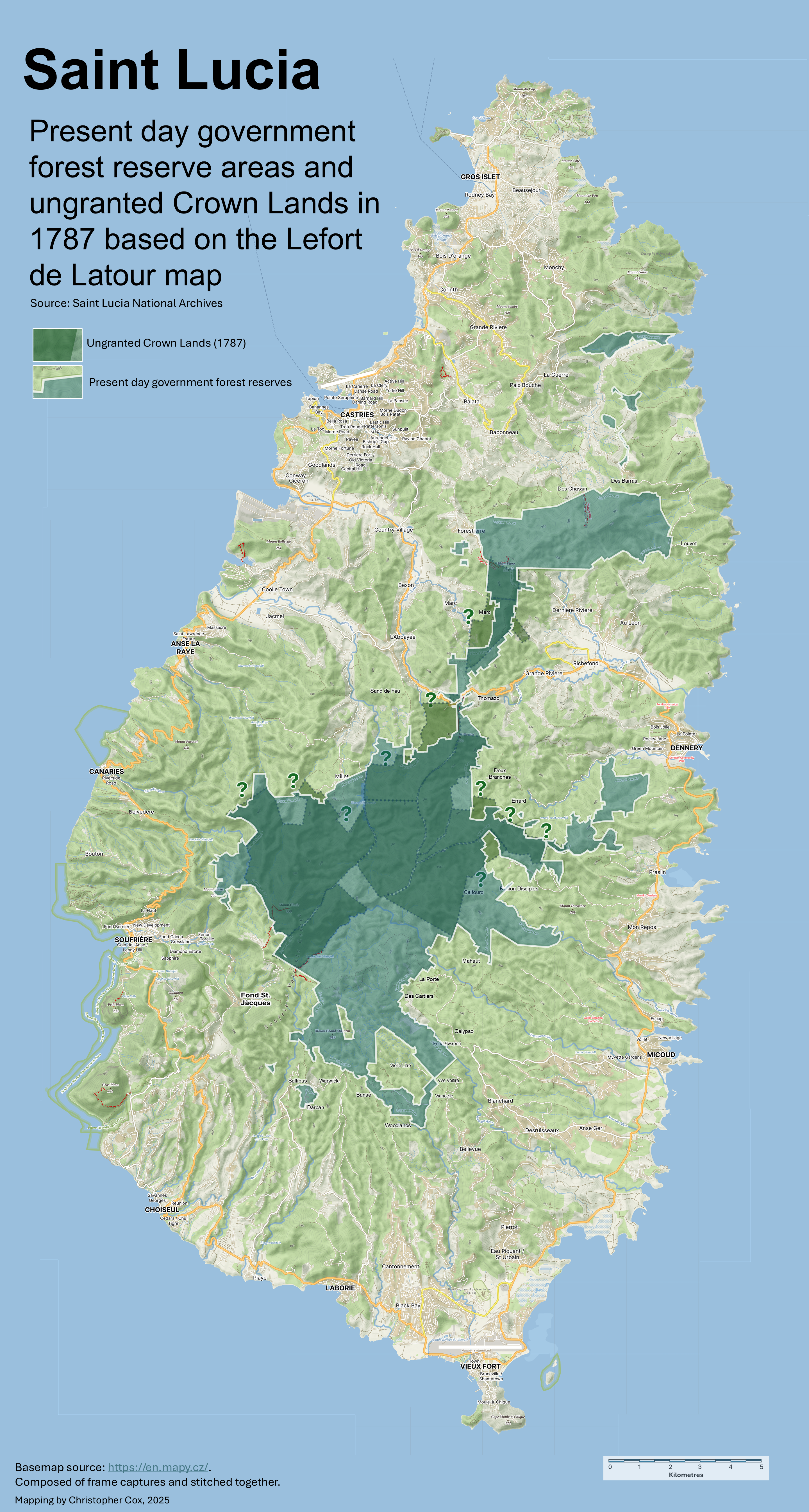
The ‘composite’ map below (traced from an original, held in the Saint Lucia National Archives collections) illustrates the estates as compiled in the 1787 mapping by French surveyor to the King of France, Jean-François Lefort de LaTour with the ungranted Crown Lands in green shade that constituted the beginnings of the core forest reserve areas. It clearly shows that at the time of the survey the vast majority of lands were granted to settlers. Only the most inaccessible interior lands remained ungranted. (note: the delineation of the ungranted Crown Lands was discerned as best as possible, given the quality of the map reproduction; could be improved with a clearer version map).
Click or tap on the map below for a detailed view

The system the French adopted for naming the estates are of note. Estate names, that mainly took the family names of the owners were encoded with the name of the estate and followed by a number and the a letter either ‘R’ or ‘B’. The ‘R’ signified ‘red’ that indicated that the estate owner was European and ‘B’ signified ‘black’ indicating that the estate owner was of African or ‘coloured’ descent.
By 1803 the British gained control over Saint Lucia, having changed title with the French fourteen times. Slavery was abolished in 1834 with the emancipation of the slaves. Many of the slaves that were displaced and lacking access to lands, moved from the estates and coastal villages to Crown Lands in the rugged interior of the island to cultivate. The cultivation method typically employed the destructive practice of slash and burn; clearing the forest over vast areas, then burning the felled vegetation, with the organic matter and ash residue providing fertility to the soil. When the soil nutrients were eventually exhausted, adjacent areas would be cleared and burned in a similar manner in a process known as ‘shifting cultivation’. In those days the Colonial Government regularized squatting through the sale of Crown Lands in parcels of any size at a nominal figure of 10 shillings per acre (source Saint Lucia Environmental Profile, 1991).
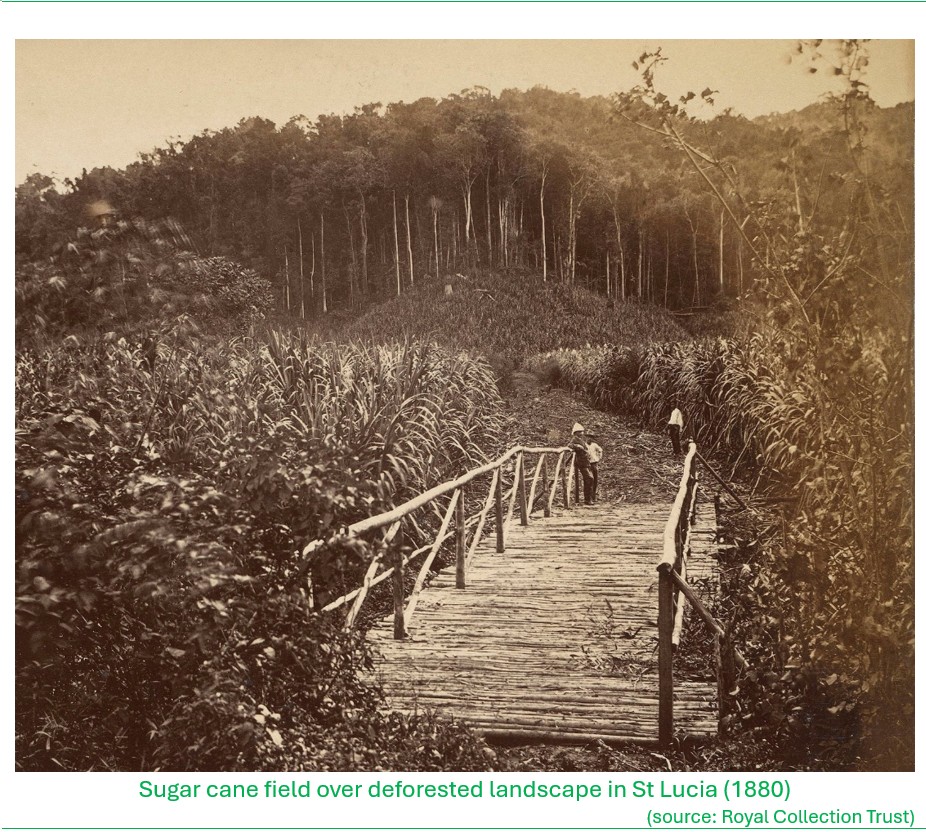
While the changes in the landscape through the early settlement days were not documented or surveyed, on examination of old illustrations and photos that became available from the late 1800’s, it appears that significant areas of original forests had been converted to crop and livestock agriculture and settlement areas, and otherwise transformed to degraded landscapes.
Click or tap on the maps to view in high-resolution

The state of native vegetation and forests on Saint Lucia seems to be generally absent from any published narratives up until the late 1800s, although some scientific writings on the wildlife of the island were published dating back to the late 1600s with the first description of the St. Lucia Amazon (St. Lucia Parrot or Jacquot) by German zoologist Philipp Ludwig Statius Müller in 1776. By the latter years of the 19th century, poor land management practices and resulting land degradation appears to have reached a point when it drew the attention and concern of the colonial administration.
In 1887, E. D. M. Hooper of the Indian Forest Department visited Saint Lucia as part of a mission to carry out assessments of forests in several islands of the British West Indies. His assessment was contained in a ‘Report upon the Forests of St. Lucia‘. At the time when Hooper carried out his study it was estimated that between 50,000 to 60,000 acres (20,200 to 24,300 hectares) or about one third of the island was still forested. Mr. Hooper made recommendations concerning the protection of St. Lucia’s forests, among the most important being that there should be no more clearing of forest lands owned by the Crown. He recommended that the boundaries of forested lands be clearly marked and that a Forest Warden be appointed to manage the resource.
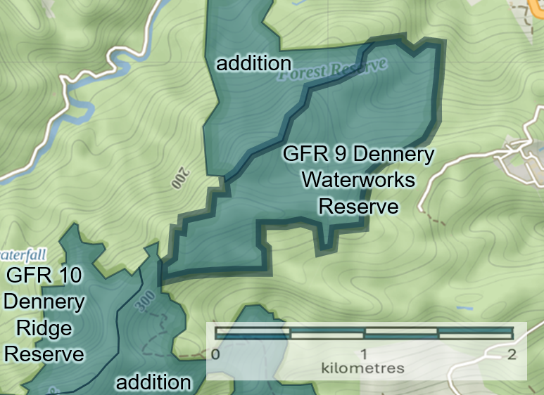
Based on the Hooper report recommendations, two new pieces of legislation were enacted; the Crown Lands Ordinance that was passed in 1916. In that year the Castries Waterworks Reserve, Dennery Waterworks Reserve and Warrick Forest Reserve were gazetted. This was followed by the passing of the Timber Protection Ordinance in 1918 which was designed to prevent the unlawful felling of timber on Crown and vacant land.
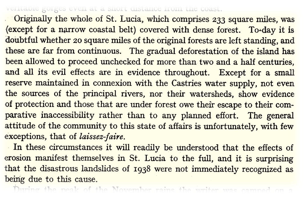
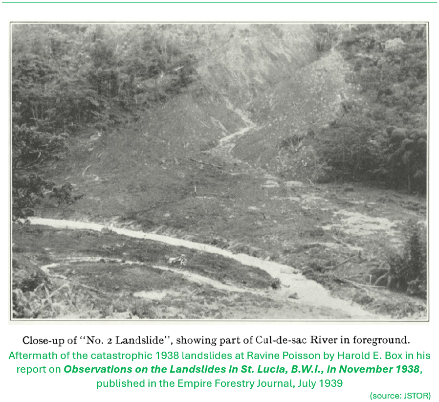
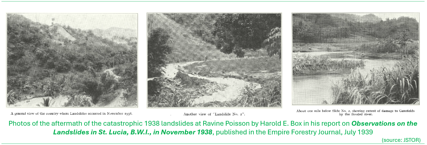
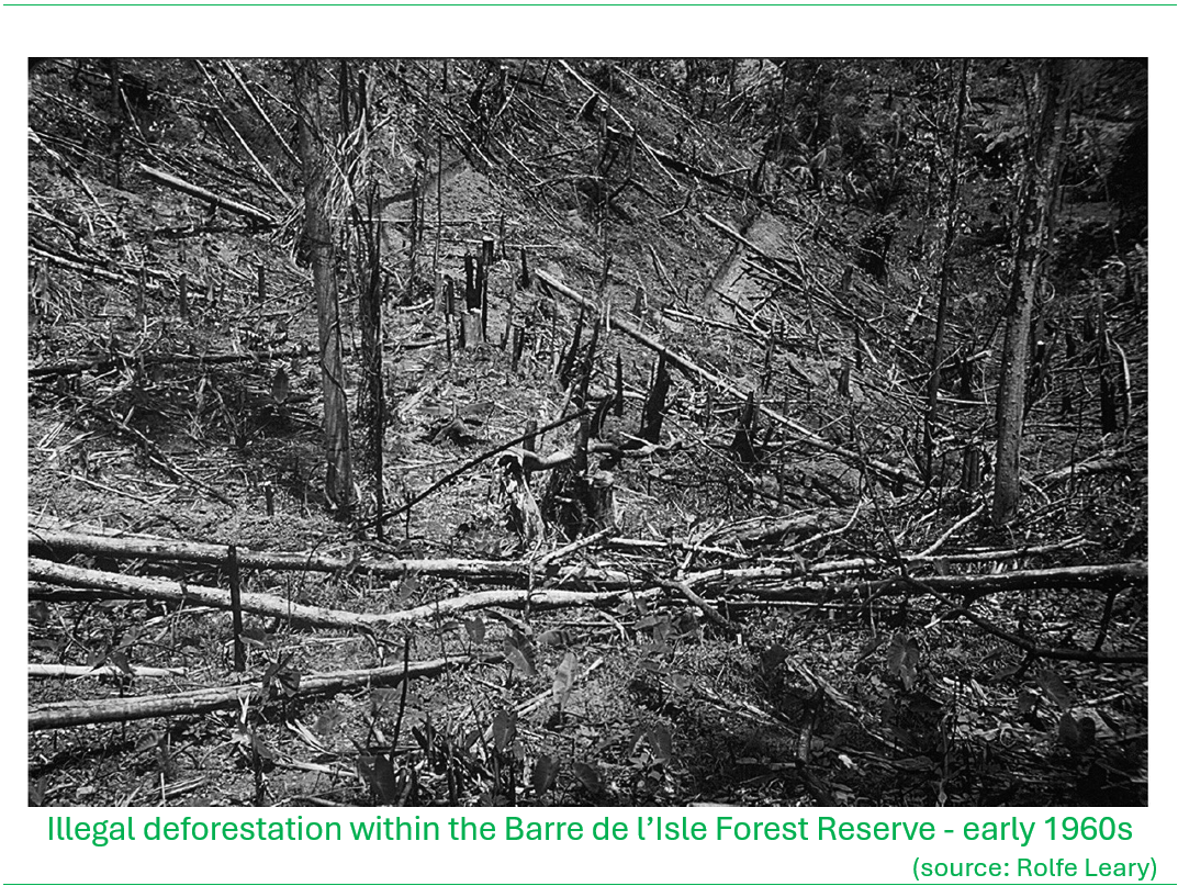
The poignant moment that marked the turn toward action to address forest destruction was with the occurrence of the devastating landslides at Ravine Poisson in November 1938, to be remembered as ‘Black Monday’, where at least 150 people lost their lives. The landslides were triggered by persistent rains over 21-22 November that contributed to already saturated conditions of the soils that underlaid the deforested hillslopes. As far back as 1922, it was documented that hundreds of acres of land along the Barre de l’Isle had been cleared for the cultivation of bananas. In 1928, when Panama Disease wiped out the crop, most of the land was abandoned. Professor Claude W. Wardlaw, a pathologist in banana research, described the area as; “a grass grown, barren waste with roadways overgrown by bush and obliterated by landsides.” (BushTalk Book 1, The Forest). With the loss of the tree cover and the root network that would have stabilized the soil, the unfortunate outcome for the people living in the shadow of the Barre de l’Isle was only a matter of time
Harold E. Box gave an account of the Ravine Poisson disaster in his article on Observations on the Landslides in St. Lucia, B.W.I., in November 1938, published in the Empire Forestry Journal, July, 1939. He was in Saint Lucia at the time, collecting botanical specimens for the British Museum. Some excerpts of text from his report below, elaborates the circumstances that eventually led to the disaster.

Photos of the aftermath from the report by Harold Box.

Urgent call to save the forest
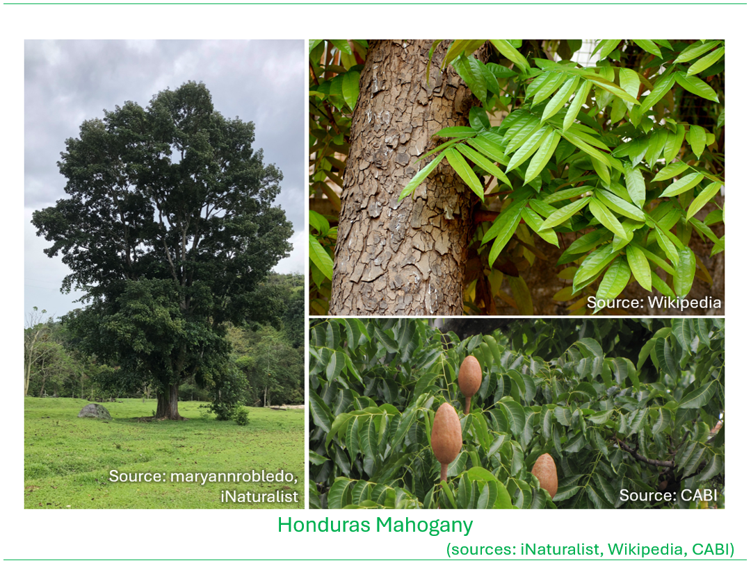
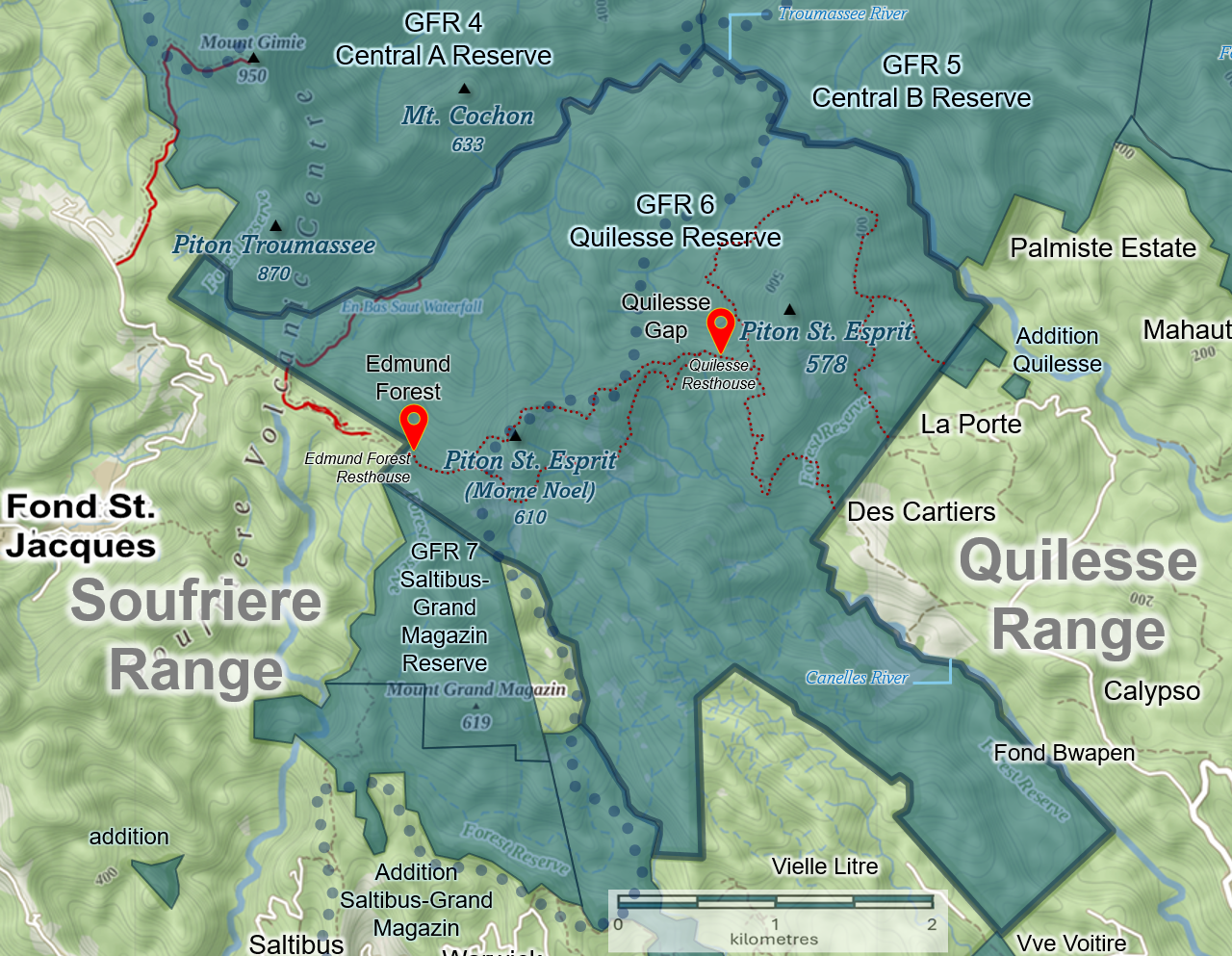
Significant efforts at stabilizing deforested lands were undertaken in the aftermath of Black Monday. Sometime in the mid to late 1930s the head of the Department of Agriculture, Superintendent Niles brought Honduras Mahogany (Swietenia macrophylla) seeds from Honduras to Saint Lucia for reforestation, but also given its excellent timber properties. The intention was to plant in uniformity as it was thought at the time that forests of only one type of tree would be more economic and easier to manage. A 15-acre plantation of Mahogany was established at Quilesse near Piton St. Esprit as an experiment (BushTalk Book 1. The Forest).
E.Y. Wald, the then Agricultural Superintendent of St. Lucia wrote in the Caribbean Forester in 1939 (Vol. 1, No.1) of the impacts of continued exploitation of the forests ” … the importance [of forests] in soil and moisture conservation, particularly in the vicinity of the headwaters of the principal rivers, cannot be overstated, and it is unfortunate that these points have been appreciated insufficiently in the past.” (source Saint Lucia Environmental Profile, 1991).
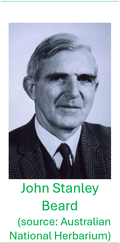
Prior to the mid-1940s the Forest Department of Trinidad & Tobago assisted the local colonial governments of the Windward and Leeward islands in provision of technical advice regarding the management of the forest resource. Dr. John Stanley Beard, the then Assistant Conservator of Forests of Trinidad and Tobago, visited Saint Lucia in 1944, observing that there were still problems with squatting and illegal cutting of trees, in spite of the laws to protect the forests. At the time the prevailing legislation was the Timber Protection Ordinance which was passed in 1918 to prevent the unlawful felling of timber on Crown and vacant land. He recommended that a dedicated Forestry Division be established within the Ministry of Agriculture so as to strengthen the ability to enforce the laws and protect the forests, and the legislation strengthened. In addition, any unclaimed land in the centre of the island should be taken over by the Government and added to the Forest Reserve. (Commonwealth Forestry Review, 1971).
In early 1945 the Forest, Soil and Water Conservation Ordinance No. 6 (now Act by 1982 amendment) was approved by the Saint Lucia Legislative Council. The Forestry Division was established the following year under the Department of Agriculture with the appointment of a Forest Supervisor, one Senior Forest Officer, two Forest Rangers, three Forest Guards and three Forest Watchers. At that time (Beard’s inventory), the Government held title to a little over 2,000 hectares (5,000 acres) of forested lands in the interior of the island, including the Castries Waterworks Reserve, Warrick Reserve (near Saltibus), Barre de l’Isle Forest Reserve, and the Quilesse Forest Reserve (St. Lucia Environmental Profile, 1991).
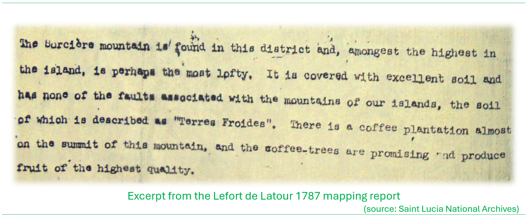
The first attempt to classify the vegetation of Saint Lucia was carried out by Dr. Beard; his work, part of a wider study for the Eastern Caribbean, was published in 1949 in a report titled the Natural Vegetation of the Windward and Leeward Islands. Beard’s vegetation map for Saint Lucia shows large swaths of lands in the interior of the island that were categorized as ‘secondary forest’ (illustrated in orange shade on the map below). Secondary forest or secondary vegetation, generally refers to vegetation that regenerates following disturbance of the original vegetation. In the case of Saint Lucia, such disturbances will have been the result of generations of land clearing for agriculture, timber and fuelwood extraction, whereby the original forests, save for the most remote and inaccessible, will have been felled at some time or other. Indeed, in the narrative of the Lefort de Latour mapping of 1787, it was noted that coffee was being cultivated at La Sorciere near its summit indicating the extent to which the original forests may have been modified.
From the map, the secondary forest areas extend from the Barre de l’Isle Ridge westward to Ravine Poisson to Millet and Venus in the extremely rugged west central areas, from Mahaut, across the southern mountain core through Belle Vue to Fond St. Jacques, and along the length of the Dennery River and upland from Praslin and Derniere Riviere to Aux Lyons on the flanks of La Sorciere.
The ‘undisturbed’ or ‘primary’ forest types that Beard classed (Elfin Woodland, Montane Thicket, Rain Forest / Lower Montane Rain Forest and Lower Montane Rain Forest) at the time remained only in the more inaccessible areas in the southern mountains, along the Barre de l’Isle and the areas from Piton Flore to La Sorciere.
The dry scrub forests mapped as intermittent tracts along the coastal margins could be assumed as also having been disturbed and modified to varying degrees, likely exploited for charcoal and cultivation of crops such as cassava and cashew nut that grow better in drier areas. The area in the extreme north was classed as savanna and grazing lands signaling that these landscapes were perhaps completely transformed from the original vegetation due to grazing.
The remainder of the unclassified lands were assumed to be under varying levels of active human influence; in the rural areas and settlement hinterlands, agricultural cultivation that would likely range from intensive short-term cropping (sugar cane, vegetables, root crops, bananas/plantains) to mixed cultivation incorporating tree crops (mango, breadfruit, citrus, cacao, coconut). Settlement areas would be principally confirmed to the coastal strip and along path and roadways traversing the landscape.
Based on the spatial extents of the vegetation classes Beard illustrated in his mapping, the ‘primary’ or undisturbed forests of the interior, namely elfin woodland, montane thicket, rainforest and lower montane rainforest will have constituted approximately 11% of the total area. Dry scrub woodlands along the coastal areas constituted 19%. Secondary forest constituted 11% of the land area, considered forests that were historically deforested and regenerating.
Click or tap on the map below for a detailed view

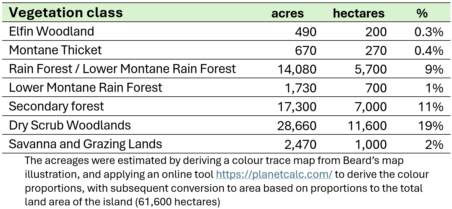
The unclassified area constituting 35,130 ha or 86,810 acres will have approximated 57% of the land area assumed to be mainly under cultivation of varying intensities with pockets of urban and rural settlement areas.
Forestry management takes shape
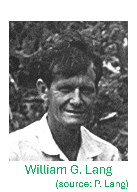
In 1946 William G. Lang a native of Grenada, was appointed as the island’s very first Forest Supervisor by Acting Governor of the Windward Islands, Edward Twinning, to lead efforts toward an organized and formalized forest resources management programme for the country. Under Lang’s leadership, the Forestry Division expanded the areas under protected management under the new forestry ordinance, with the establishment and declaration of the Quilesse Reserve and the Dennery Waterworks Reserve in 1946. This was complementary to the ongoing efforts to plant denuded areas to address the effects of deforestation. This included work on the Barre de l’Isle Ridge were various exotic species of timber trees were planted.
The priority for forest management in Saint Lucia over the ensuing decades was to prevent further disastrous landslides as occurred in 1938, focusing on tree planting, with somewhat less of an emphasis on wildlife and ecological considerations. The priority was underpinned by the dual role that reforestation served; to conserve the soil but also to yield timber and fuelwood. In the early days, local wood was used extensively for construction, including the building of the traditional ‘canot’ fishing canoes, and to make charcoal used for cooking. The species therefore selected for planting were those that not only had good growth rates to quickly establish vegetation cover over exposed land surfaces (with deep rooting to stabilize the soil), but were also valuable for timber and other commercial uses.
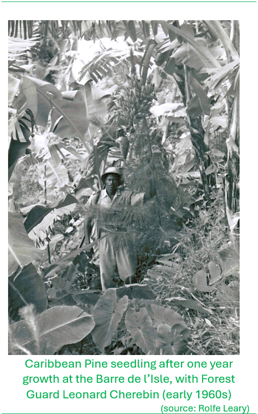
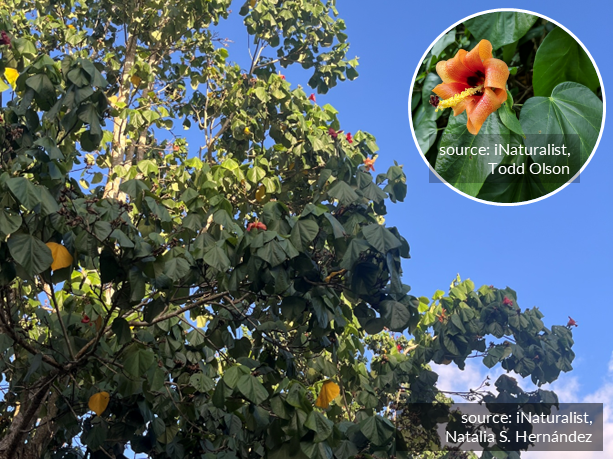
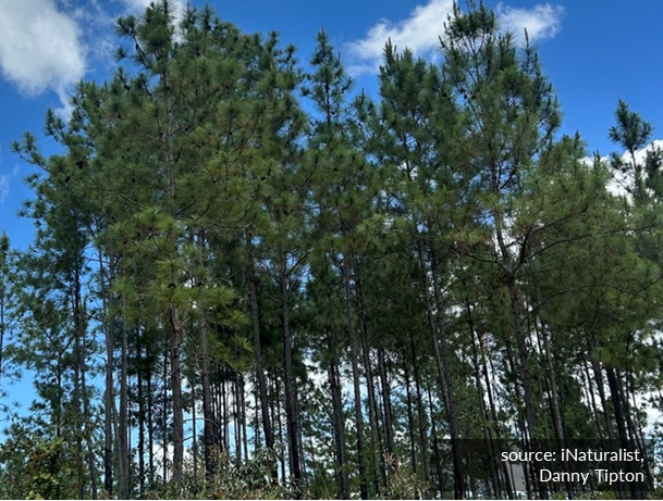
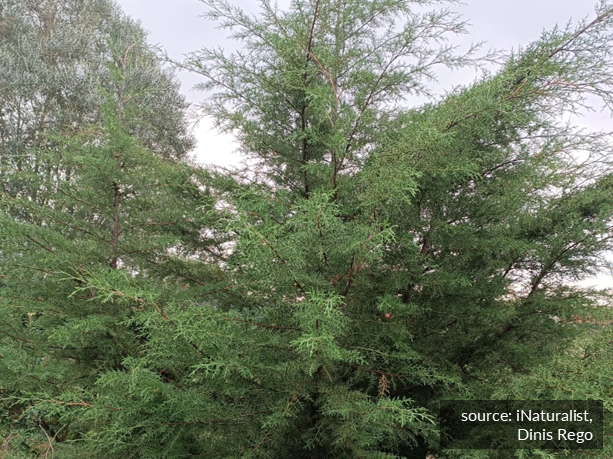
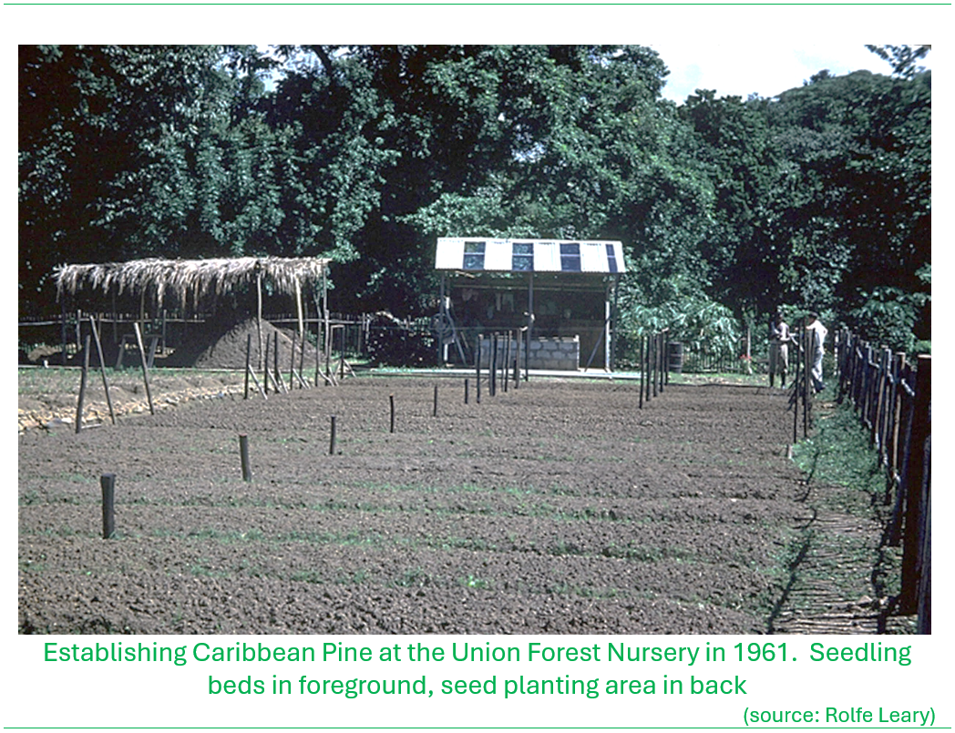
In 1950 William Lang introduced Blue Mahoe (Hibiscus elatus) into Saint Lucia, a fast-growing species native to Jamaica, where it was planted extensively at Edmund Forest and along the Barre de l’Isle Ridge. This tree, in addition to Honduras Mahogany, would be the next most planted exotic timber, known for its characteristic purple-bluish heartwood that contrasts with its paler sandy-colored sapwood. Caribbean Pine (Pinus caribaea), native to Central America and the northern islands in the Caribbean was introduced to Saint Lucia in 1961, when R. Ayliffe, the Conservator of Forests for the Windward Islands, recommended planting this species. Plantations of Caribbean Pine were established at Union, Forestiere and the Barre de l’Isle (source BushTalk, Book 1. The Forest). In that same year, Mexican Cypress (Hesperocyparis lusitanica) native to Mexico and Central America was introduced to Saint Lucia for use as Christmas trees by William Lang. In 1967 the Government banned the importation of live Christmas trees to grow the market for locally-grown trees. Teak (Tectona grandis), native to southeast Asia and a prized timber that was being grown extensively in Trinidad was introduced to the island likley in that same time period, and in 1979 Leucaena (Leucaena leucocephala), native to Mexico (the K8 variety) was introduced to the island to stem deforestation for the production of charcoal, that had been the mainstay of cooking fuel to a vast majority of the population, particularly in the rural areas.
To support the forest planting operations, a dedicated forestry nursery was established at Union, Castries within the Ministry of Agriculture estate (likley in the 1950s into the early 1960s) for the production of seedlings.
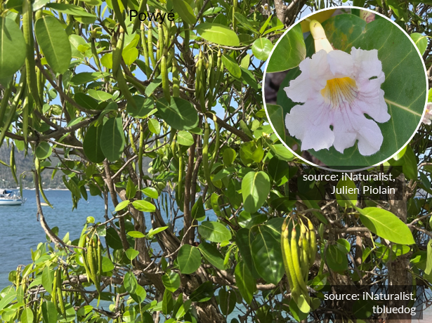
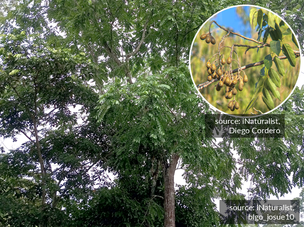
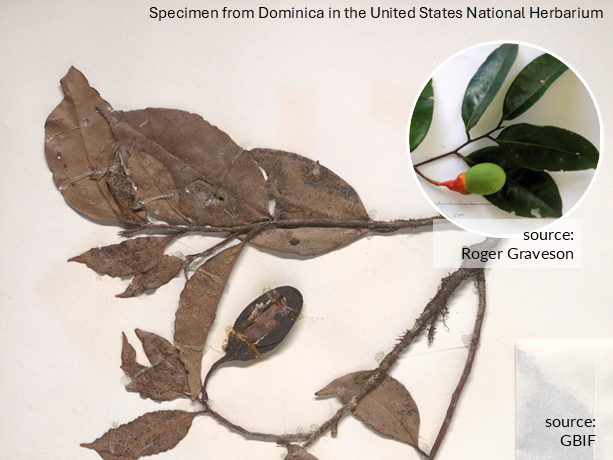
Notwithstanding the planting of exotic species for timber, there was still a significant volume of local timber being harvested from forests within declared reserves, allowed only upon issuance of a permit from the Forestry Division, and from forests on private lands. Local species that were significantly exploited included Lowyé mabwé (Ocotea leucoxylon), Gommyé (Dacryodes excelsa), Powyé (Tabebuia pallida), Bwa Blan (Simarouba amara), Acajou or Red Cedar (Cedrela odorata) and Lowyé kannèl (Aniba ramageana).
Click or tap on the images for expanded views

In the Year Book of the West Indies and Countries of the Caribbean, Volume 1952, William Lang reported that timber cut and extracted from Crown Lands across the island in 1950 amounted to 429,290 board feet. For perspective on the quantities, a typical saw board with the dimensions of 1 inch thick by 12 inches wide by 8 feet long, is equivalent to 8 board feet. Hence the timber volume harvested in that year would be equivalent to almost 54,000 8-foot boards! At the time it was reported that the main timber-based export was charcoal, which was shipped to Barbados.
Into commercial forestry

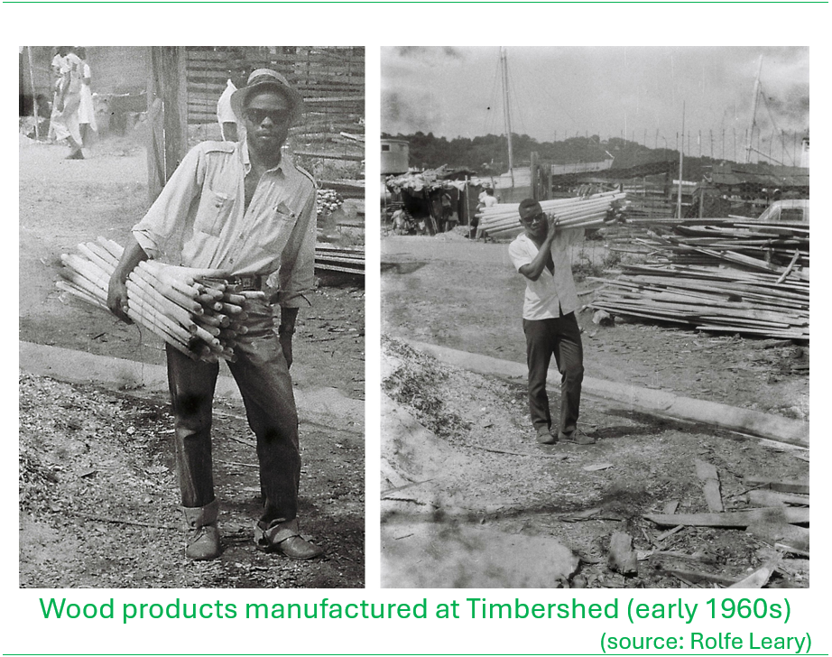
In 1953 a government-supported local timber industry was initiated, designed to encourage landowners to grow and use more local wood and build an economy around commercial forestry. By December 1954 a timber workshop known as Timbershed was established in Conway, Castries and in 1963 the Timber industry Development Board Ordinance was passed to provide for the establishment of a Timber Industry Development Board to provide oversight for sawmilling operations and guidance in commercial timber development in the country. The Board was eventually appointed in 1965.
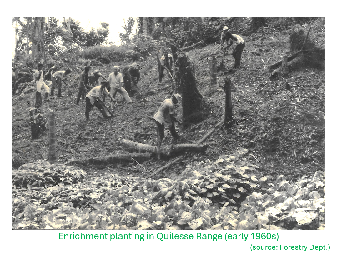
The policy of the Forestry Division in favoring production of commercially important timber species meant seeking out lands that were amenable to establishment of timber plantations. In these areas, non-commercially important species were removed and replaced with seedlings of the commercially important species in what was known as ‘enrichment planting‘ operations. These operations were carried out over extensive tracts of land particularly in Edmund Forest (upland from the Fond St. Jacques community), at La Porte and Quilesse in the mountainous interior from Mahaut in the east-central part of the island.
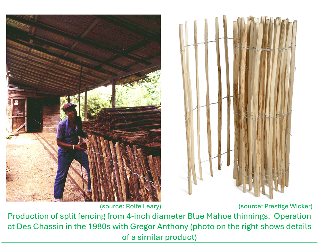
Other forest products were derived from the plantations. A fencepost production facility was set up near the Castries Waterworks Reserve at Des Chassin in the 1950s or 1960s. The fence posts were made from ‘thinnings’, which were usually young Blue Mahoe trees (about 4” diameter) that were selectively removed from plantation forests to reduce crowding and make way for the remaining more vigorous trees in the plantation to mature. Fencing was also made at the facility. They were made from posts that were split into quarters and tied in at set spacing with wire to make the ‘split fencing’ which were sold in rolls.
Recognizing the need for further enhancement of forest resource management decision making, in 1969 the Forestry Division’s first Management Plan was commissioned and prepared by John Arthur ‘Ian’ Goodlet of the United Kingdom Forestry Commission, who was at time the Conservator of Forests in Trinidad & Tobago. The plan was based on completion of an enumeration survey for the forests of the island where the effort estimated the acreages of plantations in St. Lucia. The survey revealed that… [see if there is a reference; a summary of findings?]..
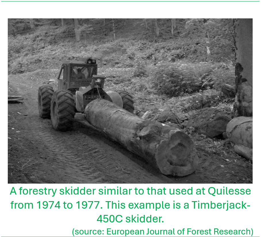
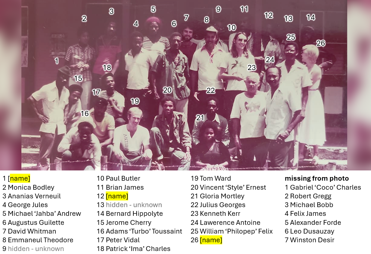
This management plan was used as the basis for the upgrading of commercial forestry operations particularly within the Quilesse Range. Bulldozers were used to cut logging roads into the forest reserve to provide motorized access to the plantations where the trees would be logged on-site, and the logs hauled to a loading bay using a specialized tractor called a skidder. This skidder operated at Quilesse. The loading bay operations on the eastern side of the forest was at La Porte, and on the western side at Edmund Forest. A truck from Timbershed would come twice a week to haul the logs to the sawmill at Conway. David Moore a forester from the UK who worked as Assistant Conservator of Forests in Trinidad & Tobago and deployed to Saint Lucia in the early 1970s, oversaw implementation of the forest management plan and the timber production operations at Quilesse. He was supported by Archibald ‘Archie’ Gajadhar, the senior forestry officer at the time who worked under William Lang. From the 1970s into the 1980s, the range officers with primary operational oversight for the timber operations in the Quilesse Reserve included Felix James, Ananias Verneuil, Michael Bobb, Lawerence Antoine and Emmaneul Theodore.
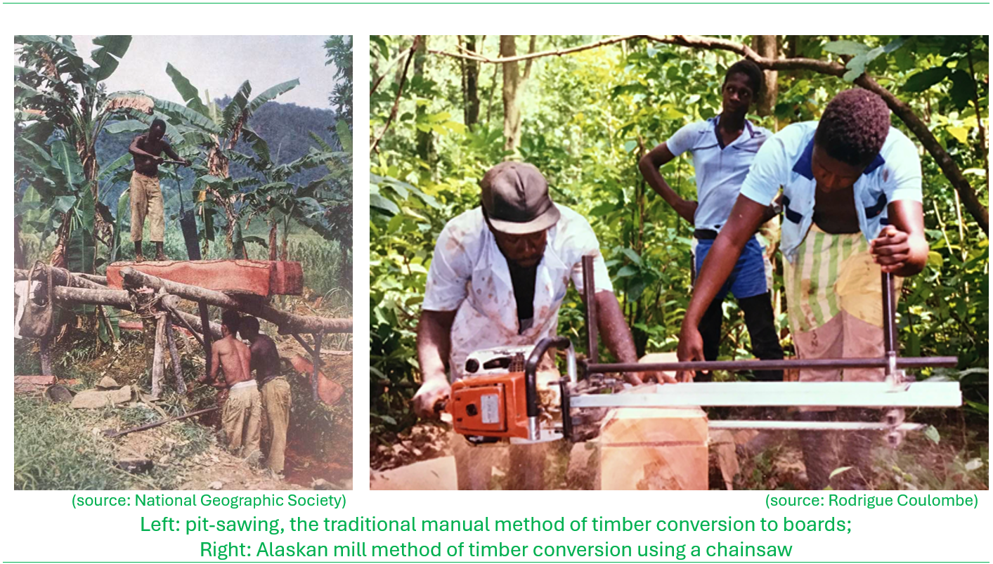
Timber production in Saint Lucia, on account of the terrain, was dominated by small-scale cutting and extraction by selective tree felling. The pit-saw technique was the traditional method employed to convert felled trees to cants (generally a rough squared-off log) and boards. With the availability of chainsaws from the late 1970s, on-site conversion shifted to the Alaskan mill method where the chainsaw would be attached to a metal rig that glided the sawblade in a parallel orientation through the wood, allowing for the sawing of uniform boards.
By the early 1980s the Timber Industry Development Board became dormant. In 1980 the government acquired Fine Timbers, a private commercial milling operation located at Patience which included the sawmill and furniture manufacturing equipment. Both the Timbershed and the Patience operation where then operating under the direct supervision of the Chief Forest Officer. Timbershed was moved from Conway to Union in 1986 to make way for the Castries waterfront development. By the late 1980s, the operations at Timbershed were discontinued however, to make way for the construction of the Ministry of Communications and Works offices. All tools and equipment were subsequently relocated to Patience. The Patience mill operated for a few more years until the property was transferred to the Ministry of Community Development for its conversion to a youth skills training center that would have entailed the utilization of the milling and furniture-making equipment to enhance vocational skills offerings to youth. The French government provided additional new equipment and financing for the project, however the intended use of the facility never fully materialized (pers. comms., Brian James, 2022).
The banana boom; its toll on the forests
The banana industry saw a rapid expansion from the 1950s that followed the gradual decline and collapse of the sugar industry. Already, banana cultivation was extensive in the island in the early part of the 20th century, but with the ravages of the Panama Disease of the 1920s and 1930s there was a push for establishment of disease-resistant bananas. The investments in the banana industry targeted the large tracts of flat, fertile lands in the Roseau, Cul de Sac and Mabouya valleys. By 1965, bananas accounted for nearly 90 percent of the country’s total exports, making Saint Lucia the first Caribbean economy dependent on the mono-cultivation of bananas (Organization of American States, 1986).

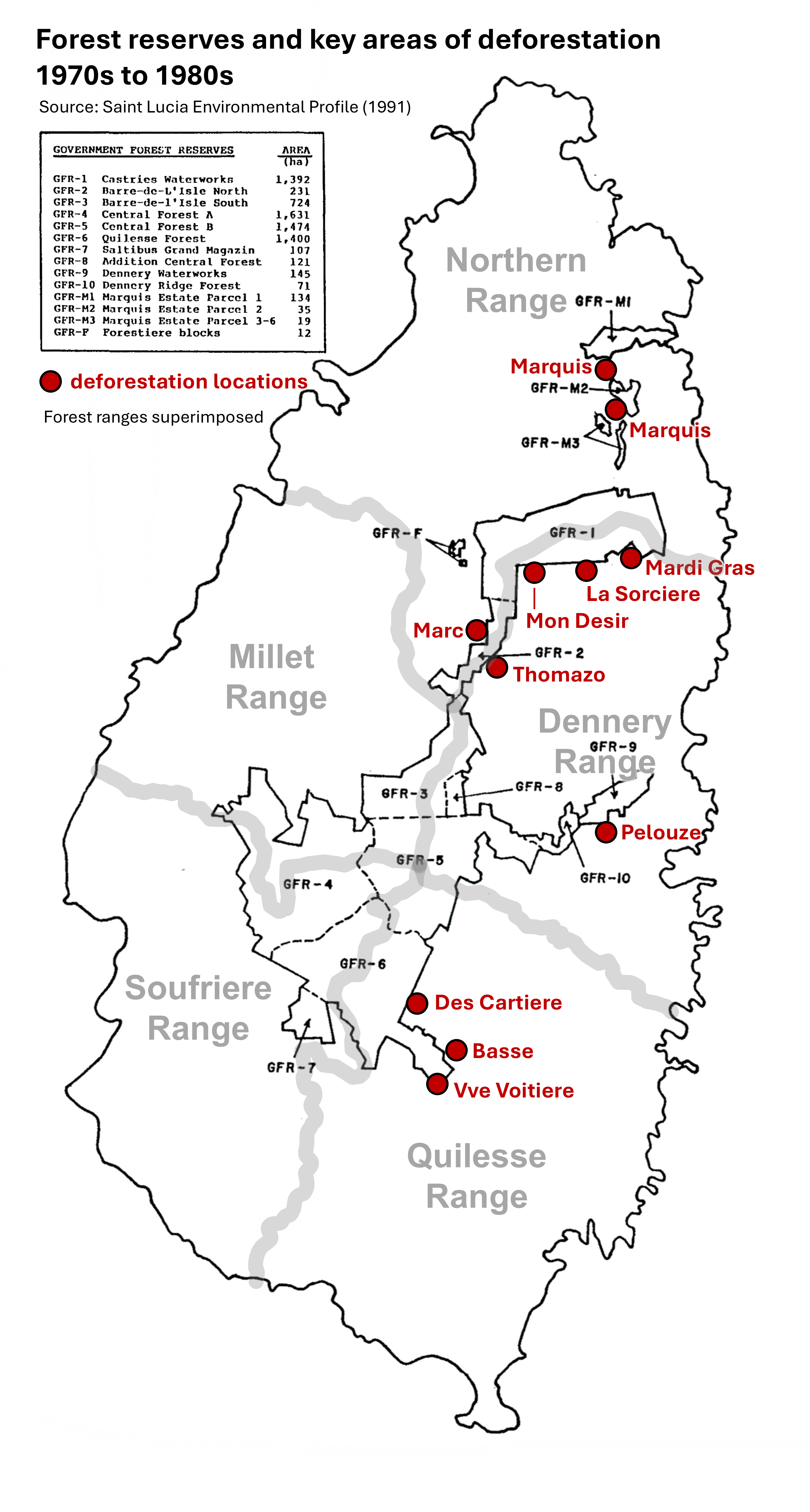
Given the ease of banana cultivation, extensive tracts of land in steeper, marginally arable areas were wantonly cleared to cultivate bananas, the native forest either cut and burned on-site, and/or converted to saw boards or charcoal. The impacts of deforestation was widespread and on private lands crept up to the margins of the forest reserves, where landless farmers often took up opportunity to squat and clear forests on Crown Lands and within the reserves themselves. Some of the most intense and devastating incursions took place in the eastern parts of the Quilesse Reserve at locations of Fon Bwapen, Vve. Voiteiere and Ville Litre, and within the southern extents of the Castries Waterworks Reserve upland from Derniere Rivere, Dennery.
In order to clamp down on the extensive deforestation island-wide, the Forestry Division, with focused attention on illicit incursions into forest reserves, instituted a system for monitoring and tracking exploitation of forest produce whereby removal permits were required by the public in order to transport timber and bamboo on public roads, regardless of the location from where they were sourced; private and government (Crown) lands. These permits were issued by the Division on condition that the material was extracted legitimately, whereby the system allowed for tracking the species, the location sourced and the quantities. This information served to guide decisions on how forestry practices and operations would be guided by management of the Forestry Division. The Division did allow for harvesting within forest reserves where trees could be sold to prospective buyers. On settlement of the negotiation between the responsible forest officer for the area, the tree or trees to be sold were ‘stamped’ with a special ‘stamping hammer‘ and the money collected, to be deposited in the government treasury. A removal permit was then issued to allow for legal haulage on the road.
Redoubling forest conservation efforts
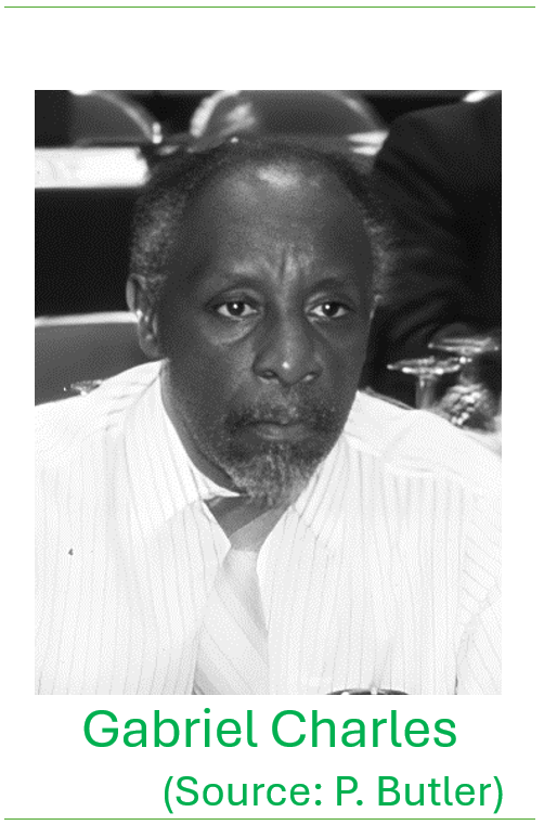
By 1971 William Lang retired and for a brief period, George Durrant Glasgow followed by David Moore, held on in the role of Forest Supervisor. At the time Cyril Matthew was the Director of Agriculture who had oversight for the Forestry Division. In that year Gabriel Charles was appointed the first Saint Lucian Forestry Supervisor.
Commencing in 1982 the Government of Canada through the Canadian International Development Agency (CIDA) provided financial and technical assistance to the Government of Saint Lucia under a multi-phased Forest Management and Conservation Project. The project sought to strengthen the capacity of the country to manage its forest resources, recognizing the threats posed by the aggressive rates of deforestation that was plaguing the country, as a result of conversion of lands for banana cultivation and harvesting of wood for timber and fuel. In 1982 a major forest inventory was undertaken by Pat O. Piitz, the silviculture expert under the project. Among the main findings of the inventory included…[ summary of key findings]
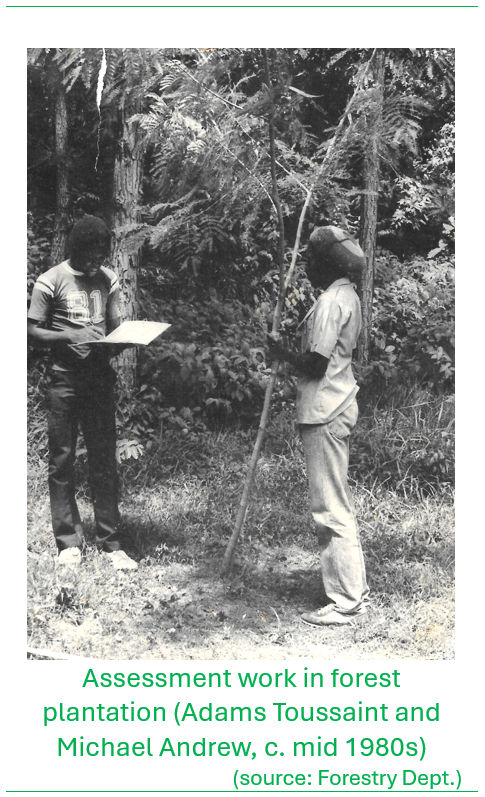
Further studies on forest productivity and timber yields were carried out by Tom Ward, a United States Peace Corps Volunteer to Saint Lucia who established permanent sample plots in the mid-1980s at various locations in the forest reserve to measure growth and predict wood volume yields from Honduras Mahogany plantations. This work was carried forward under the oversight by Michael ‘Jahba’ Andrew, who was assigned at the time to the research portfolio of the Division.
The largest single forest plantation established was at Edmund Forest, covering a total of 85 hectares (210 acres). By the late 1980s the estimated standing volume for Honduras Mahogany, Blue Mahoe and Caribbean Pine was 45,722.7 m3. In the forestry inventory exercises under the CIDA-financed Forestry Management Project Piitz (1983) derived estimates of average annual wood production (or ‘mean annual increment’ in forestry terms) in the forest plantations and the natural forest. For the exotic species in the forest plantations the annual growth estimates were as follows: 6.7 m3 per hectare per year for Blue Mahoe, 8.6 m3 per hectare per year for Honduras mahogany, and 9.0 m3 per hectare per year for Caribbean pine. On the other hand, the mean annual increment for the natural forest (tropical moist to subtropical rainforest) was estimated to have a much slower growth rate; at 1.6 m3 per hectare per year. (source: Country Report: Forestry Outlook Study for the Caribbean, by Lyndon John in the report Proceedings of Sub-Regional Workshop on Data Collection and Outlook Effort for Forestry in the Caribbean Port-of-Spain, Trinidad & Tobago 21-25 February 2000. Data derived from the St. Lucia Management & Conservation Project, 1989).[any updates?].
The CIDA forestry project conducted a land use assessment by acquiring satellite imagery and supplementing it with ground-truth observations from 1989 to 1992. This process produced an updated land use map, which was used to determine forest cover on the island for management purposes. The 1992 land use survey revealed that agricultural land use extended in virtually all areas right up to the forest reserve boundaries. The only areas where forests remained relatively intact were in the central western mountains in the upper reaches of the Canaries watershed toward Mt. Parasol where the terrain is excessively steep.
Click or tap on the map to view in high-resolution
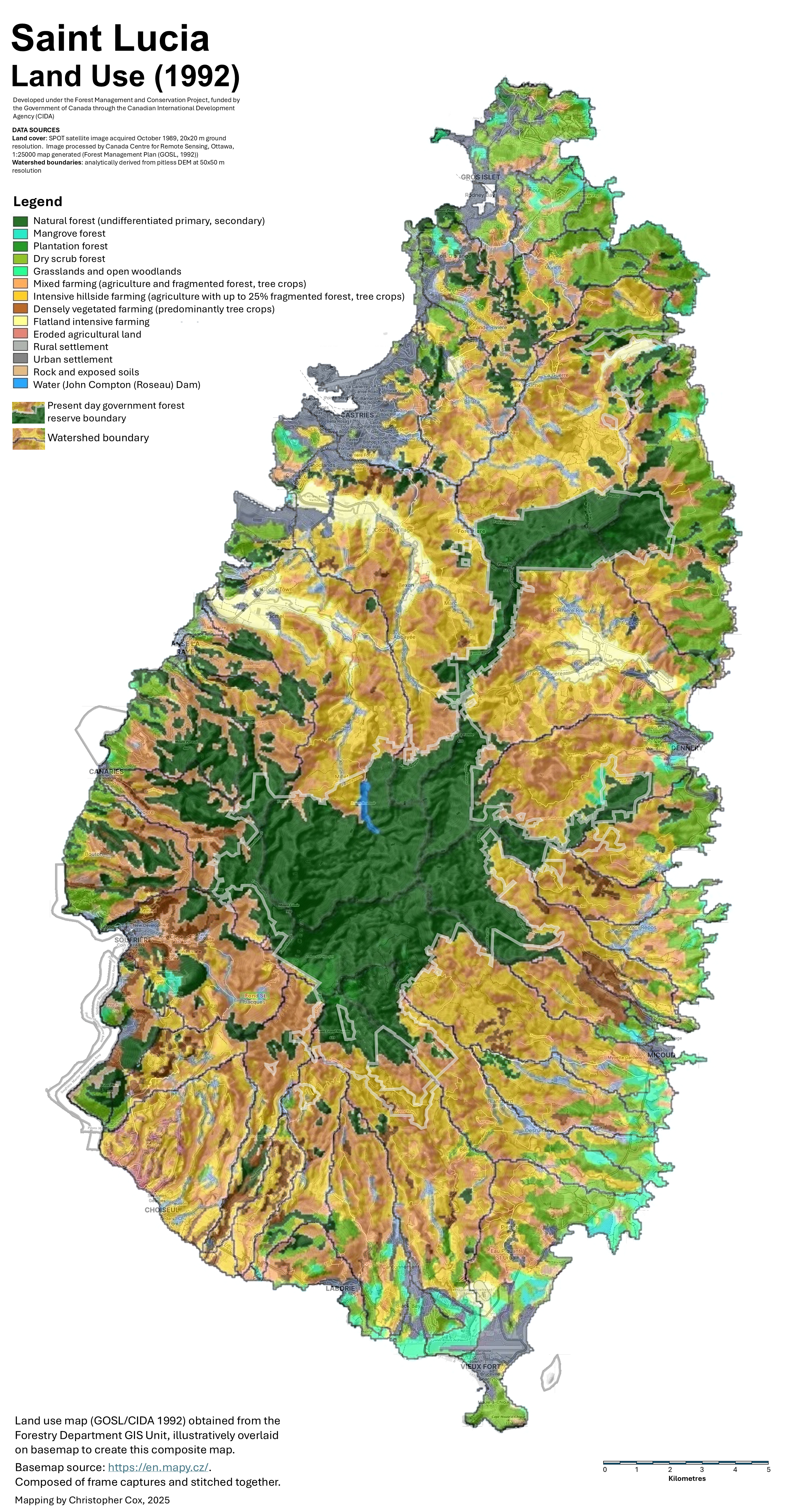

In this 1992 assessment forests and natural vegetation classes constituted some 21,741 hectares (53,723 acres) or 35% of the total land area, and agriculture in all classes constituted 34,015 hectares (84,053 acres) or 55% of the total land area.
Over time, transitioning into the 1990s as timber imports to the island grew to meet growing demands, the need to harvest local timber from the established forest plantations (and also from private lands in general) declined and the management strategy for forest plantations shifted from commercial production objectives to land conservation, moreso for plantations located in more remote locations with challenging terrain. The Forestry Department still maintained some level of thinning operations in plantations, mainly in the Honduras Mahogany and Blue Mahoe stands, to attain good form and favorable yields of timber, but the management intensity of this work declined significantly
An assessment of forest resource utilization was analyzed by Lyndon John (Research Forester) and presented in a year 2000 report drawing on Timber Removal Permit data. He estimated that only about 75% of the actual volume of extractions were contained in the records due to relatively poor enforcement of the removal permitting system. His assessment of the data revealed that over the periods 1983 to 1990 and 1995 to 1998 that several local species that were once more readily available, had gone into decline. These species included [list].
[insert paragraphs on the wildlife conservation programme, watershed management, recreational tourism and environmental education programme]
With technical and policy expertise brought in by the project, the Department developed a successor 10-Year Forestry Management Plan to cover the period 1992 to 2002. The Forest Management and Conservation Project and CIDA’s engagement came to a close in 1993.
Building capacity over the years
In the years since the establishment of the Forestry Division, its technical and enforcement capability was gradually enhanced with the employment of a team of forestry officers and forest guards. Given the challenges associated with combating illegal forest clearing on Crown Lands and forest reserves, patrolling by foot in remote areas was routine. Forestry officers and forest guards were known locally as ‘police bwa’ and it was customary that select officers were issued firearms for protection.

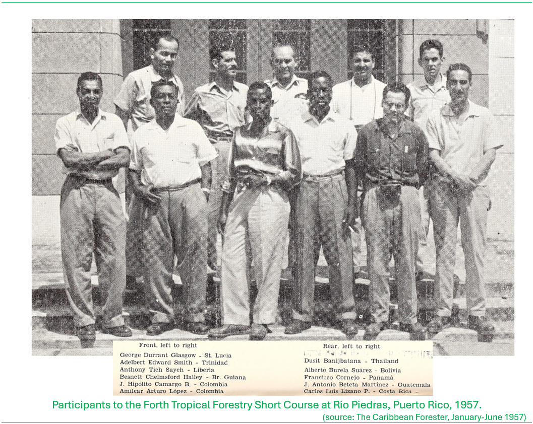
There was also emphasis placed on building up knowledge on forestry and silvicultural practice in order to apply effective decision-making in forest operations. From the 1950s there was ongoing collaborations with the United States Forest Service (USFS) to expose forest officers from Saint Lucia and the wider Caribbean to forestry management principles and practices, based on knowledge gained from work in Puerto Rico by the USFS, but also within the forestry community of the British Commonwealth, where in the Caribbean, Trinidad and Tobago served as the hub for propagation of ‘best-practice’ for the other territories of the British West Indies. Among the ‘early’ Saint Lucian forestry professionals who were sent to training in forestry were George Durrant Glasgow, Joseph Clarke, Gregor Hall and Gabriel Charles.
click or tap on images below for full view (George Glasgow is in the 1957 photo; Joseph Clarke and Gregor Hall are in the 1958 photo)

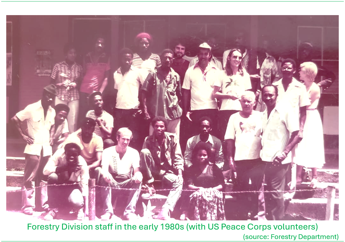
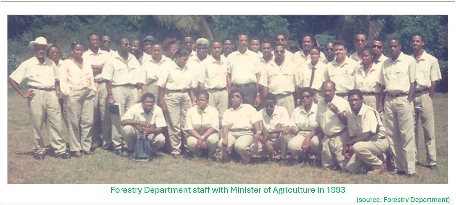
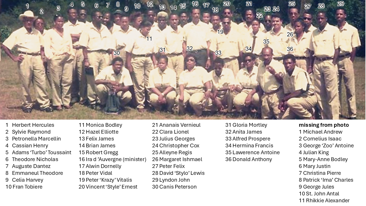
In 1985 the Forestry Division was officially upgraded to a Department under the Ministry of Agriculture as the Department of Forests and Lands, headed by a Chief Forest and Lands Officer (formerly the Chief Forest Officer), supported by a Deputy Chief Forestry Officer and assisted at the senior technical level by two Assistant Chief Forest Officers; one with responsibility for ‘forest resource conservation’ that entailed wildlife management, ecotourism, environmental education, and the other with responsibility for ‘forest operations’ that was generally related to forest plantation management, enforcement and protection. All staff positions under the old Division structure were evaluated, realigned and brought on par with the public service staff positions based on work responsibilities. Within the forestry officer positions, specialist positions were established for wildlife management, research and environmental education.
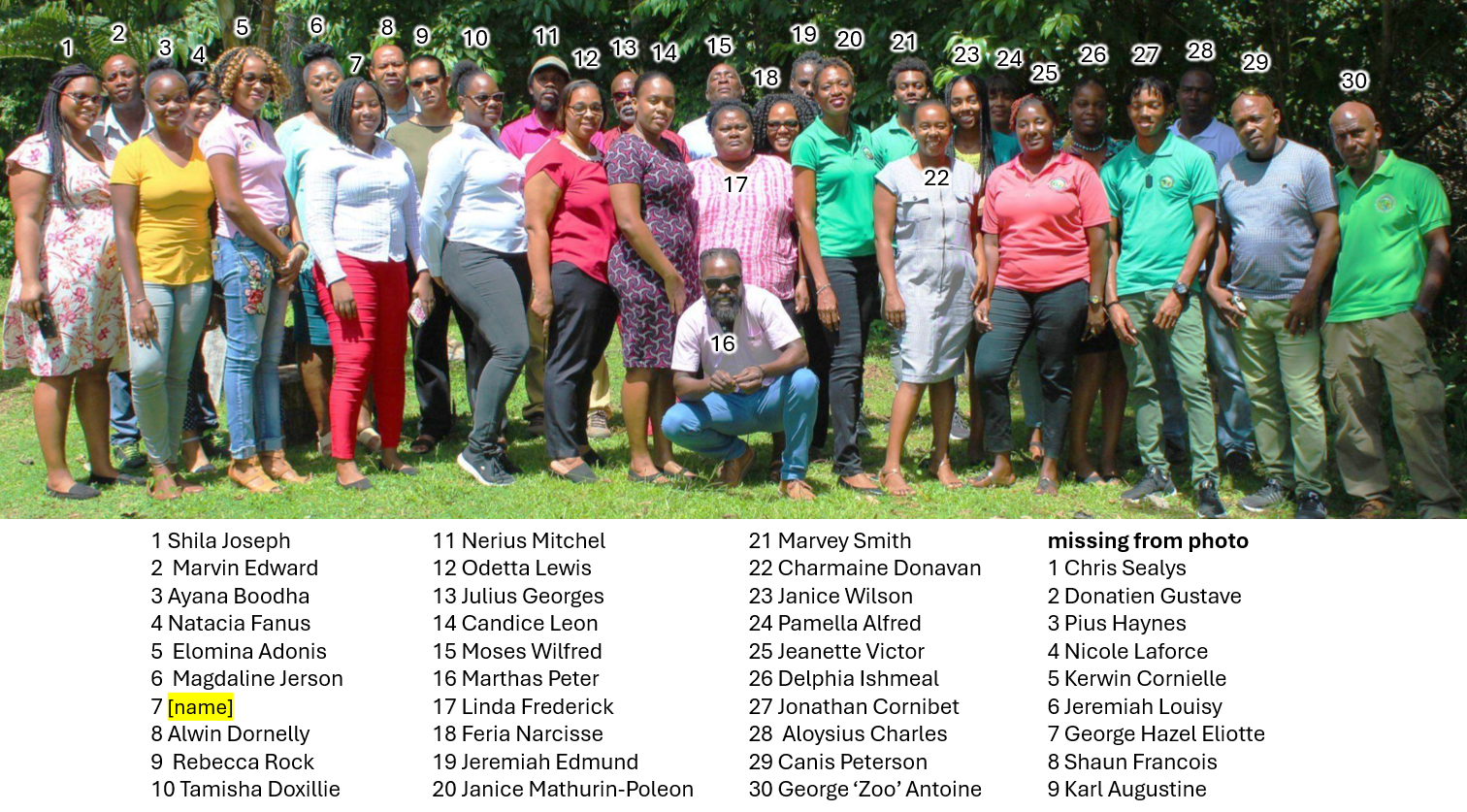
click or tap here to see the names
click or tap here to see the names

click or tap here to see the names
The Forestry Division was initially housed within the Ministry of Agriculture building that was located in downtown Castries on Mongiraud Street (behind the former Lafayette Supermarket). In the mid-1970s the division’s headquarters was relocated to George the V Park, commonly known as the ‘Gardens’ to the gardens Curator’s Office. Under the Canadian (CIDA)-funded forest management project a new headquarters facility was constructed at Union, Castries and completed in 1991. The headquarters was renamed the Gabriel Lewis Charles Forestry Complex in 1993 dedicated to the memory of Gabriel Charles.
The new headquarters included an administrative block, an interpretation center, and expanded the existing small Union Zoo facility that housed native fauna. Upgrades were also made to the forestry nursery that had long been in operation that was adjacent to the new headquarters site. The Union Nature Trail, some 1.6 kilometers long was established as part of the interpretation centre and included a medicinal garden and open seating spaces for interpretation activities for visitors. More recently, with the support of the Association for the Conservation of Threatened Parrots (ACTP), further investments were made to the interpretation facility, and Fauna and Flora International, Durrell Wildlife Conservation Trust, the Saint Lucia National Trust jointly supported the establishment of a reptile breeding centre within the compound.
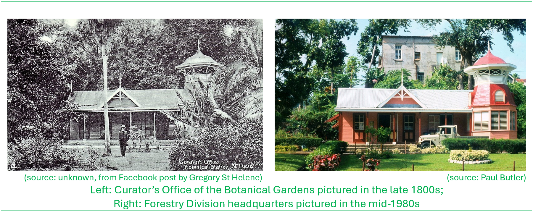
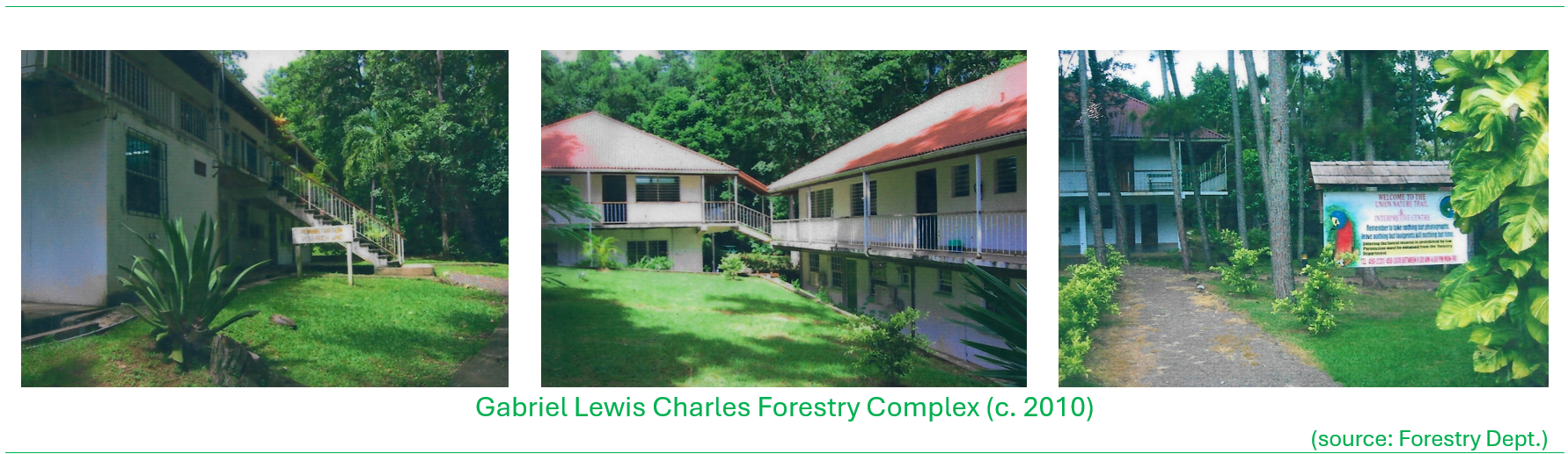
insert photo of forestry complex today; maybe drone view
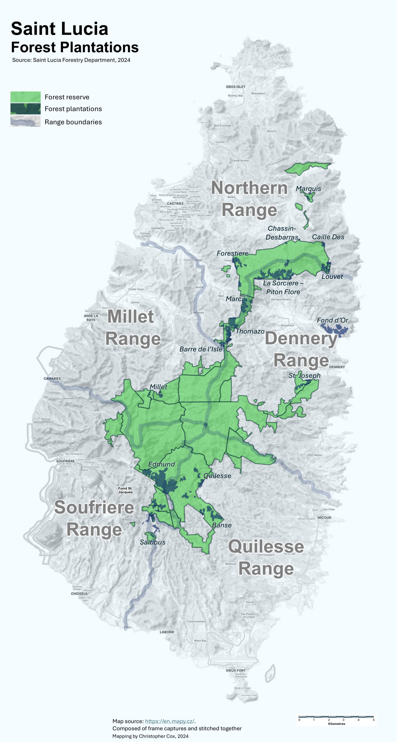
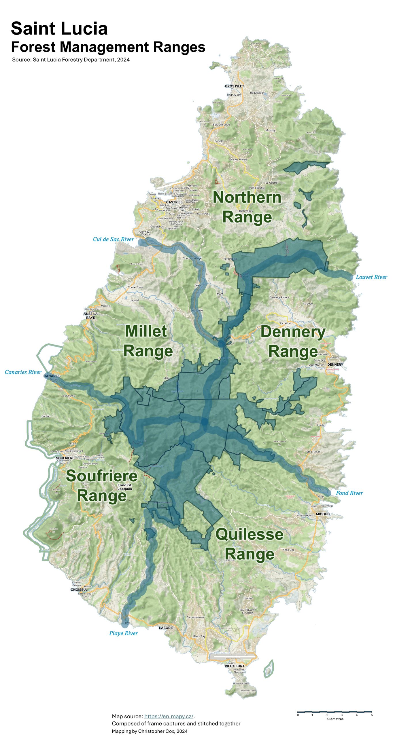
Forest Ranges
Saint Lucia is divided into five ‘area-equivalent’ regions or ranges over which forestry operations and engagement with the public would be carried out. The range areas were not only confined to within the government forest reserves but extended to other Crown Lands and private lands all the way to the coastline.
These range areas are bounded by major rivers; the Northern Range bounded to the east by the Louvet River and to the west by the Cul de Sac River; the Dennery Range bounded by the Louvet River in the north and the Fond River in the south; Quilesse Range extending from the Fond Riverin the north to the Piaye River at its southwest limits; the Soufriere Range from the Piaye River north toward the Canaries River and finally Millet Range from the Canaries River in the southern extents to the Cul de Sac River. Each Range is managed by a Range Officer and a complement of Forest Officers and field staff.
Contributors
Ananias Verneuil, Forestry Officer, Saint Lucia Forestry Department, 1970-2009
Brain James, Forestry Officer, Saint Lucia Forestry Department, 197x-2008

Christopher Cox (lead author), Forestry Officer, Saint Lucia Forestry Department, 1985-2002

Lyndon John, Forestry Officer, Saint Lucia Forestry Department, 1986-2013

Michael Bobb, Forestry Officer, Saint Lucia Forestry Department, 1976-2015

Peter Lang, Businessman, Gros Islet, Saint Lucia

Robert Gregg, Forestry Officer, Saint Lucia Forestry Department, 19xx-19xx

Rolfe Leary, Ex-US Peace Corps volunteer to Saint Lucia 1961-1963; US Forest Service